Please click here for the updated version of this post
This Post covers
- Coverage Area of Postcode CR0 to CR9
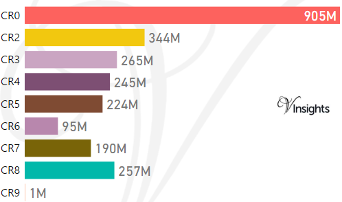
- Total Sales By Postcode CR0 to CR9 in 2017
- Average & Median Sales Price By Postcode CR0 to CR9 in 2016
- Total Number of Sales By Postcode CR0 to CR9 in 2016
- Multi Year Trend Analysis By Postcode CR0 to CR9
- Schools for Postcode Area CR
- Property Posts for Postcode Area CR
Coverage Area of Postcode CR0 to CR9
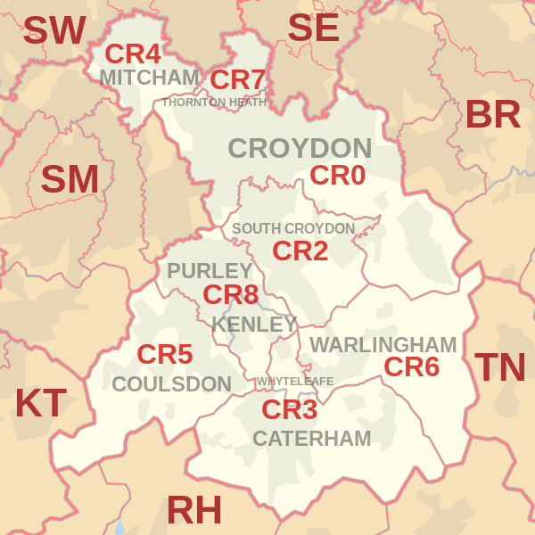 |
| Postcode |
Coverage Area |
Local Authority Area |
| CR0 |
Croydon, Addiscombe, Woodside (part), Selhurst, Broad Green, Spring Park, Shirley, Addington, New Addington, Coombe, Forestdale, Waddon, Beddington, Thornton Heath (part) |
Croydon, Sutton |
| CR2 |
South Croydon, Sanderstead, Selsdon, part of Addington |
Croydon, Sutton |
| CR3 |
Caterham, Chaldon, Woldingham, Whyteleafe, Hamsey Green |
Tandridge, Croydon |
| CR4 |
Mitcham, Mitcham Common, Pollards Hill, Eastfields, Beddington Corner |
Merton, Sutton, Croydon |
| CR5 |
Coulsdon, Old Coulsdon, Chipstead, Hooley, Netherne-on-the-Hill, part of Woodmansterne, Clockhouse |
Croydon, Reigate and Banstead, Sutton |
| CR6 |
Warlingham, parts of Chelsham and Farleigh, Hamsey Green |
Tandridge, Croydon, Bromley |
| CR7 |
Thornton Heath, Broad Green (part) |
Croydon, Merton |
| CR8 |
Purley, Kenley, Russell Hill |
Croydon, Sutton, Tandridge |
| CR9 |
Shirley |
Croydon |
Total Sales By Postcode in 2016
Average & Median Sales Price By Postcode in 2016

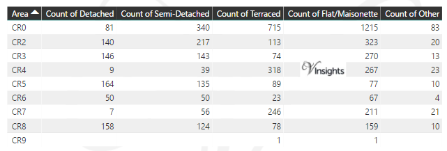
Total Number Of Sales By Postcode in 2016
Multi Year Trend Analysis By Postcode
Schools for Postcode Area CR
Property Posts for Postcode Area CR
All CR Postcodes Yearly & Trend Analysis Posts

Reference
CR Postcode Area As Per Wikipedia
8a5d3ab8-0733-4fcb-94b7-189ec7b06339|0|.0|27604f05-86ad-47ef-9e05-950bb762570c