Please click here for the updated version of this post
This Post covers
- Coverage Area of Postcode CH60 to CH66
- Total Sales By Postcode CH60 to CH66
- Average & Median Sales Price By Postcode CH60 to CH66
- Total Number of Sales By Postcode CH60 to CH66
- Property Posts For Postcode Area CH
- Schools for Postcode Area CH
Coverage Area of Postcode CH60 to CH66
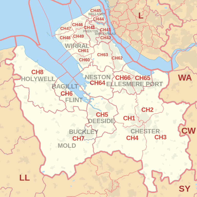 |
| Postcode |
Coverage Area |
Local Authority Area |
| CH60 |
Gayton, Heswall |
Wirral |
| CH61 |
Barnston, Heswall, Irby, Pensby, Thingwall, Thurstaston |
Wirral |
| CH62 |
Bromborough, Eastham, New Ferry, Port Sunlight, Spital |
Wirral |
| CH63 |
Bebington, Brimstage, Bromborough, Clatterbridge,
Higher Bebington, Raby, Raby Mere, Spital, Storeton, Thornton Hough |
Wirral |
| CH64 |
Little Neston, Ness, Neston, Parkgate, Puddington, Willaston |
Cheshire West and Chester |
| CH65 |
Ellesmere Port, Great Sutton, Whitby, Wolverham |
Cheshire West and Chester |
| CH66 |
Childer Thornton, Ellesmere Port, Great Sutton, Hooton, Ledsham, Little Sutton, Overpool, Whitby |
Cheshire West and Chester |
Total Sales By Postcode
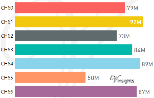
*M represents Million Pounds
Average & Median Sales Price By Postcode
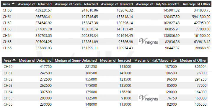
* Average and Medium Sales Price is in Pounds
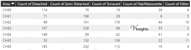
Total Number Of Sales By Postcode
Property Posts for Postcode Area CH
Schools for Postcode Area CH
- CH Postcode Area - CH1, CH2, CH3, CH4, CH5, CH6, CH7, CH8 School Details
- CH Postcode Area - CH41, CH42, CH43, CH44, CH45, CH46, CH47, CH48, CH49 School Details
- CH Postcode Area - CH60, CH61, CH62, CH63, CH64, CH65, CH66 School Details
All North West England Postcode Area Posts

Reference
CH Postcode Area As Per Wikipedia
f1b7a0d7-4d17-4a4a-aaaf-734bfae78f18|0|.0|27604f05-86ad-47ef-9e05-950bb762570c