Please click here for the updated version of this post
This Post covers
- Coverage Area of Postcode BL0 to BL9
- Total Sales By Postcode BL0 to BL9
- Average & Median Sales Price By Postcode BL0 to BL9
- Total Number of Sales By Postcode BL0 to BL9
- Schools for Postcode Area BL
Coverage Area of Postcode BL0 to BL9
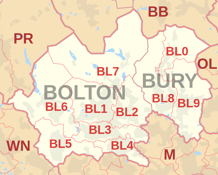 |
| Postcode |
Coverage Area |
Local Authority Area |
| BL0 |
Bury, Ramsbottom, Edenfield, Shuttleworth |
Bury, Rossendale |
| BL1 |
Bolton, Smithills, Halliwell, Heaton |
Bolton |
| BL2 |
Bolton, Ainsworth, Bradley Fold, Bradshaw,
Breightmet, Harwood, Tonge Fold, Tonge Moor |
Bolton, Bury |
| BL3 |
Bolton, Little Lever, Great Lever, Darcy Lever |
Bolton |
| BL4 |
Bolton, Farnworth, Kearsley |
Bolton |
| BL5 |
Bolton, Over Hulton, Westhoughton |
Bolton |
| BL6 |
Bolton, Blackrod, Horwich, Lostock, Rivington |
Bolton, Chorley |
| BL7 |
Bolton, Belmont, Bromley Cross, Chapeltown,
Edgworth, Egerton, Turton |
Blackburn With Darwen, Bolton |
| BL8 |
Bury, Brandlesholme, Greenmount, Affetside,
Hawkshaw, Holcombe, Ramsbottom, Tottington, Walshaw |
Bury |
| BL9 |
Bury, Heap, Heap Bridge, Nangreaves, Summerseat,
Unsworth, Walmersley, Bircle, Jericho |
Bury |
Total Sales By Postcode
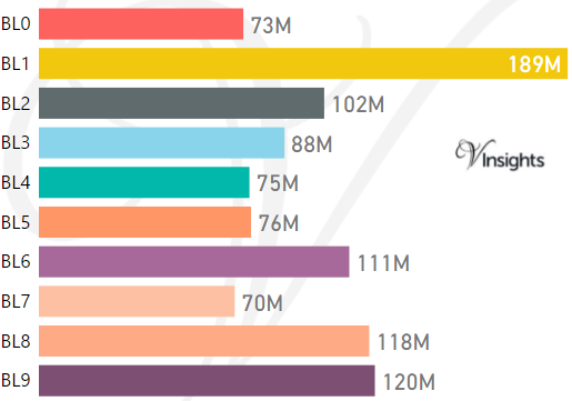
*M represents Million Pounds
Average & Median Sales Price By Postcode
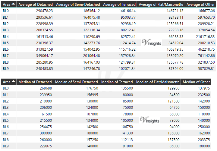
* Average and Medium Sales Price is in Pounds
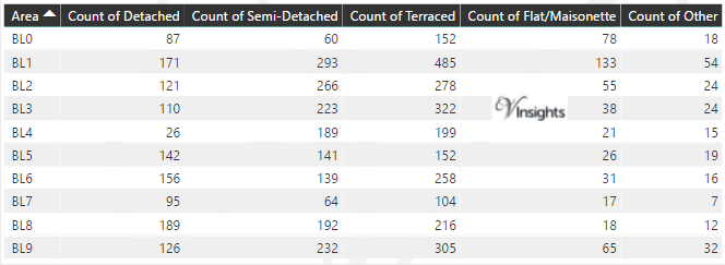
Total Number Of Sales By Postcode
Schools for Postcode Area BL
All North West England Postcode Area Posts

Reference
BL Postcode Area As Per Wikipedia
d2c1dd44-aa1c-4a62-a19b-a723069a22e7|0|.0|27604f05-86ad-47ef-9e05-950bb762570c