Please click here for the updated version of this post
This Post covers
- Coverage Area of Postcode WR1 to WR9
- Total Sales By Postcode WR1 to WR9
- Average & Median Sales Price By Postcode WR1 to WR9
- Spread of Sales Price By Postcode WR1 to WR9
- Total Number of Sales By Postcode WR1 to WR9
- Other Property Posts for Postcode Area WR
- Schools for Postcode Area WR
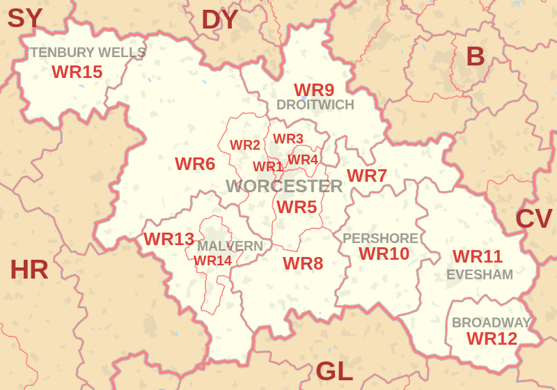
Coverage Area of Postcode WR1 to WR9
|
|
| Postcode |
Coverage Area |
Local Authority Area |
| WR1 |
Worcester |
Worcester |
| WR2 |
Powick, Hallow |
Worcester, Malvern Hills |
| WR3 |
Fernhill Heath, Claines |
Worcester, Wychavon |
| WR4 |
Warndon, Long Meadow |
Worcester, Wychavon |
| WR5 |
Kempsey, Broomhall |
Worcester, Wychavon, Malvern Hills |
| WR6 |
Martley, Clifton on Teme, Abberley |
Malvern Hills, Herefordshire |
| WR7 |
Inkberrow, Crowle, Upton Snodsbury |
Wychavon |
| WR8 |
Upton upon Severn, Hanley Castle, Hanley Swan |
Malvern Hills, Wychavon |
| WR9 |
Droitwich, Ombersley, Wychbold |
Wychavon, Wyre Forest |
Total Sales By Postcode
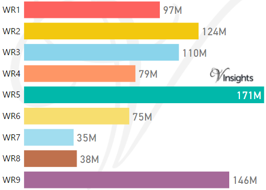
*M represents Million Pounds
Average & Median Sales Price By Postcode
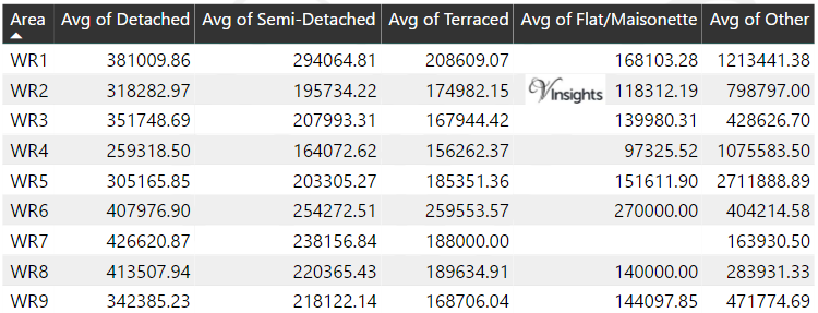
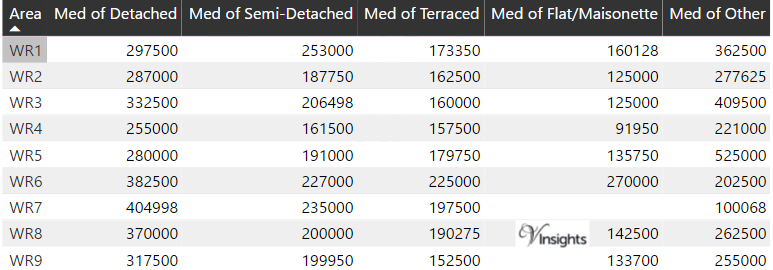
*Average and Median Sales Price are in Pounds
Spread of Sales Price By Postcode
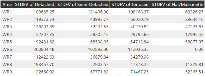
*STDEV is Standard Deviation
For example,
- Say the average detached property price for postcode XYZ is £300 K and ST. DEV. is 30 K.
- It means that most detached properties in postcode XYZ (about 68%) has price within one ST. Dev. i.e. the price range is £270K - £330K.
- All-most all detached property price (95%) in postcode XYZ lie between two ST. Dev. i.e. £240 K - £360 K
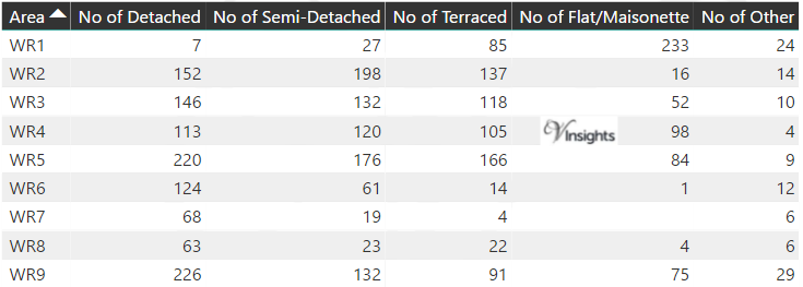
Total Number Of Sales By Postcode
Other Property Posts for Postcode Area WR
Schools for Postcode Area WR
- WR Postcode Area - WR1, WR2, WR3, WR4, WR5, WR6, WR7, WR8, WR9 School Details
- WR Postcode Area - WR10, WR11, WR12, WR13, WR14, WR15 School Details
All West Midlands Postcode Area Posts

Reference
WR Postcode Area As Per Wikipedia
6a83b06f-909e-4e98-9a63-8656a30d191d|0|.0|27604f05-86ad-47ef-9e05-950bb762570c