Please click here for the updated version of this post
This Post covers
- Coverage Area of Postcode WF10 to WF17
- Total Sales By Postcode WF10 to WF17
- Average & Median Sales Price By Postcode WF10 to WF17
- Spread of Sales Price By Postcode WF10 to WF17
- Total Number of Sales By Postcode WF10 to WF17
- Other Property Posts for Postcode Area WF
- Schools for Postcode Area WF
Coverage Area of Postcode WF10 to WF17
|
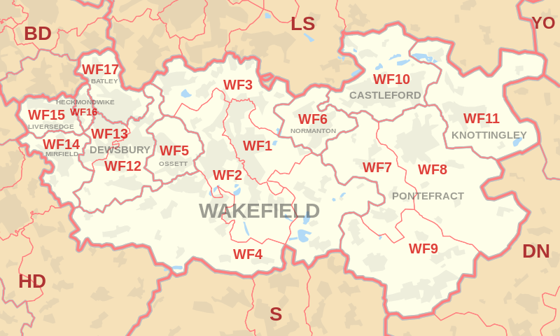
|
| Postcode |
Coverage Area |
Local Authority Area |
| WF10 |
Airedale, Allerton Bywater, Castleford, Glasshoughton |
Wakefield, Leeds |
| WF11 |
Brotherton, Byram, Cridling Stubbs, Fairburn, Kellingley, Knottingley |
Wakefield, Selby |
| WF12 |
Chickenley, Dewsbury, Savile Town, Shaw Cross, Thornhill, Thornhill Lees |
Kirklees, Wakefield |
| WF13 |
Dewsbury Moor, Ravensthorpe |
Kirklees |
| WF14 |
Hopton, Mirfield |
Kirklees |
| WF15 |
Roberttown, Liversedge |
Kirklees |
| WF16 |
Heckmondwike |
Kirklees |
| WF17 |
Birstall, Batley, Staincliffe |
Kirklees |
Total Sales By Postcode
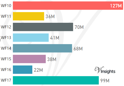
*M represents Million Pounds
Average & Median Sales Price By Postcode
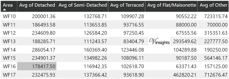
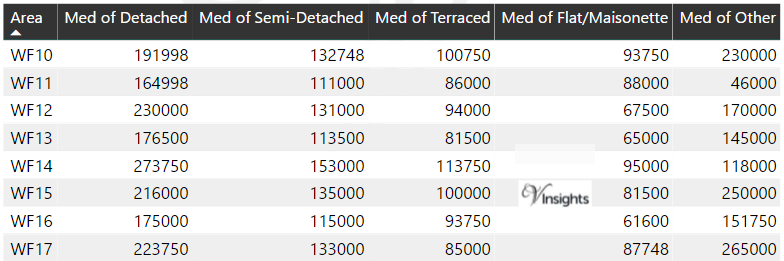
*Average and Median Sales Price are in Pounds
Spread of Sales Price By Postcode
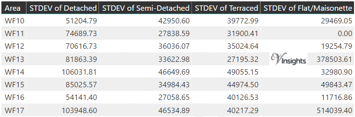
*STDEV is Standard Deviation
For example,
- Say the average detached property price for postcode XYZ is £300 K and ST. DEV. is 30 K.
- It means that most detached properties in postcode XYZ (about 68%) has price within one ST. Dev. i.e. the price range is £270K - £330K.
- All-most all detached property price (95%) in postcode XYZ lie between two ST. Dev. i.e. £240 K - £360 K
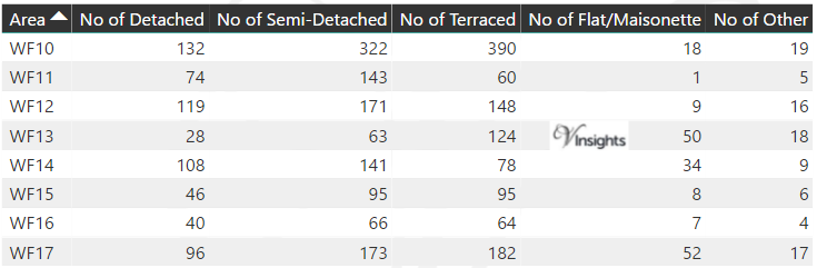
Total Number Of Sales By Postcode
Property Posts for Postcode Area WF
Schools for Postcode Area WF
- WF Postcode Area - WF1, WF2, WF3, WF4, WF5, WF6, WF7, WF8, WF9 School Details
- WF Postcode Area - WF10, WF11, WF12, WF13, WF14, WF15, WF16, WF17 School Details
All Yorkshire & Humber Postcode Area Posts

Reference
WF Postcode Area As Per Wikipedia
ed80464e-80e1-458f-8fb9-9e2ad9abb14c|0|.0|27604f05-86ad-47ef-9e05-950bb762570c