1. March 2018 08:32
/
VInsights Team
/
/
Comments (0)
Please click here for the updated version of this post
This Post covers
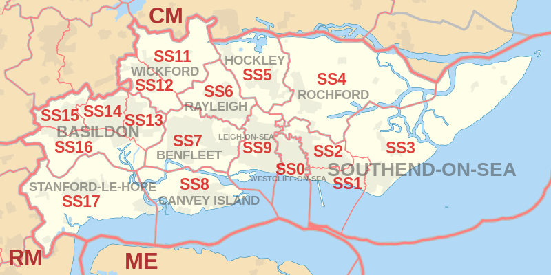 |
| Postcode |
Coverage Area |
Local Authority Area |
| SS0 |
Westcliff-on-Sea, Chalkwell |
Southend-on-Sea |
| SS1 |
Southend-on-Sea, Thorpe Bay |
Southend-on-Sea |
| SS2 |
Southend-on-Sea, Prittlewell, Southchurch |
Southend-on-Sea |
| SS3 |
Shoeburyness, Great Wakering, Little Wakering, Barling |
Rochford, Southend-on-Sea |
| SS4 |
Rochford, Ashingdon, Canewdon, Stambridge, Paglesham |
Rochford |
| SS5 |
Hockley, Hullbridge, Hawkwell |
Rochford |
| SS6 |
Rayleigh |
Rochford |
| SS7 |
Hadleigh, South Benfleet, Thundersley |
Castle Point |
| SS8 |
Canvey Island |
Castle Point |
| SS9 |
Eastwood, Leigh-on-Sea |
Southend-on-Sea |
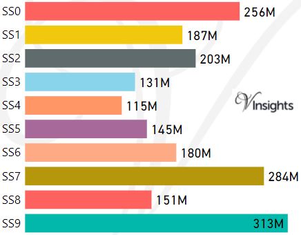
- M represents Million Pounds
- Total value includes Property Type Other apart from Detached, Semi-Detached, Terraced, Flat/Masionette
- SS Postcode Area - SS0, SS1, SS2, SS3, SS4, SS5, SS6, SS7, SS8, SS9 School Details
- SS Postcode Area - SS11, SS12, SS13, SS14, SS15, SS16, SS17 School Details
All SS Postcodes Yearly & Trend Analysis Posts

Reference
SS Postcode Area As Per Wikipedia
99afd316-77f3-426b-aad8-ae850a725039|0|.0|27604f05-86ad-47ef-9e05-950bb762570c
Tags :