24. April 2018 12:37
/
VInsights Team
/
/
Comments (0)
Please click here for the updated version of this post
This Post covers
Coverage Area of Postcode S20 to S36
|
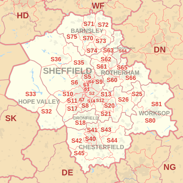
|
| Postcode |
Coverage Area |
Local Authority Area |
| S20 |
Beighton, Crystal Peaks, Halfway, Mosborough, Owlthorpe, Sothall, Waterthorpe, Westfield |
Sheffield |
| S21 |
Eckington, Killamarsh, Renishaw, Spinkhill |
North East Derbyshire |
| S25 |
Anston, Dinnington, Laughton-en-le-Morthen |
Rotherham |
| S26 |
Aston, Aughton, Harthill, Kiveton Park, Swallownest, Todwick, Wales |
Rotherham |
| S32 |
Calver, Eyam, Grindleford, Hathersage, Stoney Middleton |
Derbyshire Dales |
| S33 |
Bamford, Bradwell, Castleton, Edale, Hope, Yorkshire Bridge |
High Peak |
| S35 |
Chapeltown, Crane Moor, Ecclesfield, Grenoside, High Green, Oughtibridge, Thurgoland, Wharncliffe Side, Wortley |
Sheffield |
| S36 |
Penistone, Thurlstone, Millhouse Green, Oxspring, Stocksbridge, Deepcar Bolsterston |
Barnsley, Sheffield |
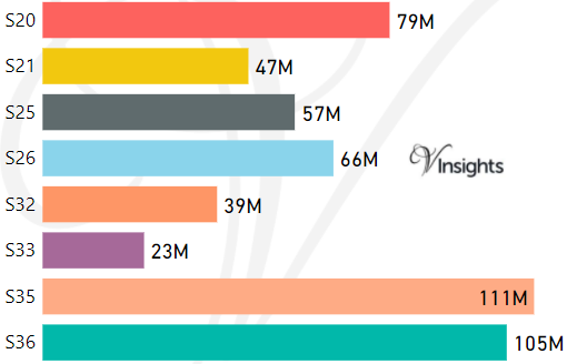
- M represents Million Pounds
- Total value includes Property Type Other apart from Detached, Semi-Detached, Terraced, Flat/Masionette
Schools for Postcode Area S
- Sheffield S Postcode Area - S1, S2, S3, S4, S5, S6, S7, S8, S9 School Details
- S Postcode Area - S10, S11, S12, S13, S14, S17, S18 School Details
- S Postcode Area - S20, S21, S25, S26, S32, S33, S35, S36 School Details
- S Postcode Area - S40, S41, S42, S43, S44, S45 School Details
- S Postcode Area - S60, S61, S62, S63, S64, S65, S66 School Details
- S Postcode Area - S70, S71, S72, S73, S74, S75, S80, S81 School Details
Property Posts for Postcode Area S
94bd5f89-e72c-42a3-b171-8912bc6b89f5|0|.0|27604f05-86ad-47ef-9e05-950bb762570c
Tags :