20. February 2018 16:37
/
VInsights Team
/
/
Comments (0)
Please click here for the updated version of this post
This Post covers
Coverage Area of Postcode ME10 to ME20
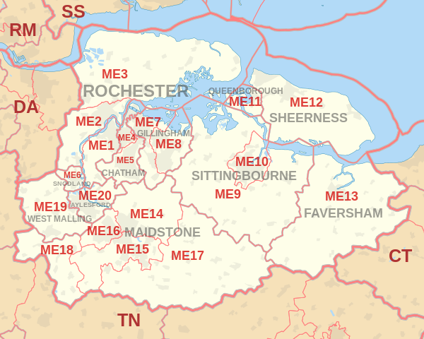 |
| Postcode |
Coverage Area |
Local Authority Area |
| ME10 |
Sittingbourne, Kemsley, Milton Regis |
Swale |
| ME11 |
Queenborough, Rushenden |
Swale |
| ME12 |
Isle of Sheppey, Minster, Sheerness, Eastchurch |
Swale |
| ME13 |
Faversham, Boughton under Blean, Selling and rural area |
Swale |
| ME14 |
Maidstone, Bearsted, Grove Green |
Maidstone |
| ME15 |
Bearsted (Madginford), Downswood, Shepway2, Senacre, Maidstone Town Centre, Loose, Mangravet, Park Wood, Tovil, East Farleigh, West Farleigh |
Maidstone |
| ME16 |
Barming, Allington and west Maidstone |
Maidstone |
| ME17 |
Hollingbourne, Hucking, Harrietsham, Lenham, Boughton Monchelsea, Linton, Coxheath, Chart Sutton, East Sutton, Langley, Kingswood, Sutton Valence |
Maidstone |
| ME18 |
Wateringbury, Mereworth, Teston, Nettlestead, West Peckham, Yalding, Laddingford |
Maidstone, Tonbridge and Malling |
| ME19 |
West Malling, Kings Hill, Leybourne, East Malling |
Tonbridge and Malling |
| ME20 |
Aylesford, Ditton, Larkfield, Eccles |
Tonbridge and Malling |
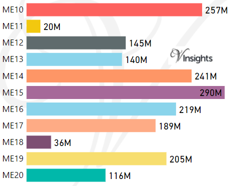
- M represents Million Pounds
- Total value includes Property Type Other apart from Detached, Semi-Detached, Terraced, Flat/Masionette
Schools for Postcode Area ME
- ME Postcode Area - ME1, ME2, ME3, ME4, ME5, ME6, ME7, ME8, ME9 School Details
- ME Postcode Area - ME10, ME11, ME12, ME13, ME14, ME15, ME16, ME17, ME18, ME19, ME20 School Details
Property Posts for Postcode Area ME
All ME Postcodes Yearly & Trend Analysis Posts

Reference
ME Postcode Area As Per Wikipedia
aaa33073-ae4d-489b-95e6-dc75709bb99b|0|.0|27604f05-86ad-47ef-9e05-950bb762570c
Tags :