14. April 2018 17:18
/
VInsights Team
/
/
Comments (0)
Please click here for the updated version of this post
This Post covers
Coverage Area of Postcode M1 to M9
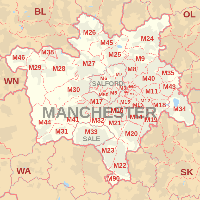 |
| Postcode |
Coverage Area |
Local Authority Area |
| M1 |
Piccadilly, City Centre, Market Street |
Manchester |
| M2 |
Deansgate, City Centre |
Manchester |
| M3 |
City Centre, Deansgate, Castlefield, Blackfriars, Greengate, Trinity |
Manchester, Salford |
| M4 |
Ancoats, Northern Quarter, Strangeways |
Manchester |
| M5 |
Ordsall, Seedley, Weaste, University |
Salford |
| M6 |
Pendleton, Irlams o' th' Height, Langworthy, Seedley, Charlestown |
Salford |
| M7 |
Higher Broughton, Cheetwood, Lower Broughton, Kersal |
Salford |
| M8 |
Crumpsall, Cheetham Hill |
Manchester |
| M9 |
Harpurhey, Blackley |
Manchester |
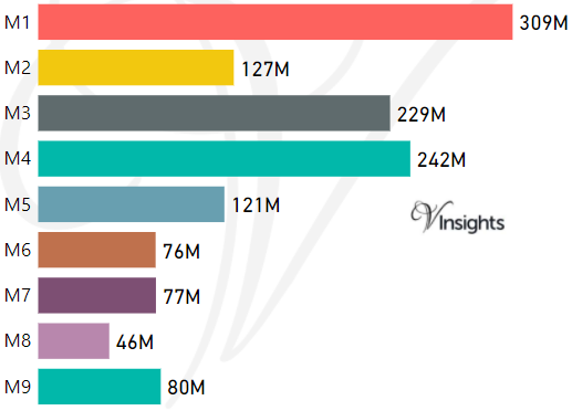
- M represents Million Pounds
- Total value includes Property Type Other apart from Detached, Semi-Detached, Terraced, Flat/Masionette
Schools for Postcode Area M
- M Postcode Area - M1, M2, M3, M4, M5, M6, M7, M8, M9 School Details
- M Postcode Area - M11, M12, M13, M14, M15, M16, M17, M18, M19 School Details
- M Postcode Area - M20, M21, M22, M23, M24, M25, M26, M27, M28, M29 School Details
- M Postcode Area - M30, M31, M32, M33, M34, M35, M38 School Details
- M Postcode Area - M40, M41, M43, M44, M45, M46, M50 School Details
Property Posts for Postcode Area M
ef406b6f-1ea2-4880-9b5f-5fe7a65264b4|0|.0|27604f05-86ad-47ef-9e05-950bb762570c
Tags :