13. April 2018 20:40
/
VInsights Team
/
/
Comments (0)
Please click here for the updated version of this post
This Post covers
Coverage Area of Postcode L10 to L19
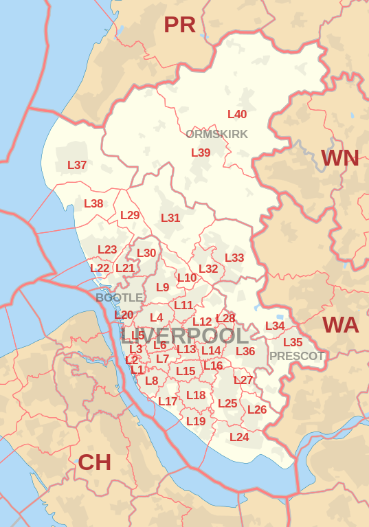 |
| Postcode |
Coverage Area |
Local Authority Area |
| L10 |
Aintree Village, Fazakerley |
Sefton, Liverpool, Knowsley |
| L11 |
Clubmoor, Croxteth, Gillmoss, Norris Green |
Liverpool |
| L12 |
Croxteth Park, West Derby |
Liverpool |
| L13 |
Clubmoor, Old Swan, Stoneycroft, Tuebrook |
Liverpool |
| L14 |
Broadgreen, Dovecot, Knotty Ash, Page Moss |
Liverpool, Knowsley |
| L15 |
Wavertree |
Liverpool |
| L16 |
Broadgreen, Bowring Park, Childwall |
Liverpool, Knowsley |
| L17 |
Aigburth, St Michael's Hamlet, Sefton Park |
Liverpool |
| L18 |
Allerton, Mossley Hill |
Liverpool |
| L19 |
Aigburth, Garston, Grassendale, Mossley Hill |
Liverpool |
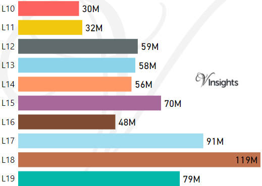
- M represents Million Pounds
- Total value includes Property Type Other apart from Detached, Semi-Detached, Terraced, Flat/Masionette
Schools for Postcode Area L
- L Postcode Area - L1, L2, L3, L4, L5, L6, L7, L8, L9 School Details
- L Postcode Area - L10, L11, L12, L13, L14, L15, L16, L17, L18, L19 School Details
- L Postcode Area - L20, L21, L22, L23, L24, L25, L26, L27, L28, L29 School Details
- L Postcode Area - L30, L31, L32, L33, L34, L35, L36, L37, L38, L39, L40 School Details
Property Posts for Postcode Area L
2c9b5c5f-fd03-4493-8aec-765e9804e9a0|0|.0|27604f05-86ad-47ef-9e05-950bb762570c
Tags :