Please click here for the updated version of this post
This Post covers
- Coverage Area of Postcode CO1 to CO9
- Total Sales By Postcode CO1 to CO9
- Average & Median Sales Price By Postcode CO1 to CO9
- Total Number of Sales By Postcode CO1 to CO9
- Schools for Postcode Area CO
- Other Property Posts For Postcode Area CO
Coverage Area of Postcode CO1 to CO9
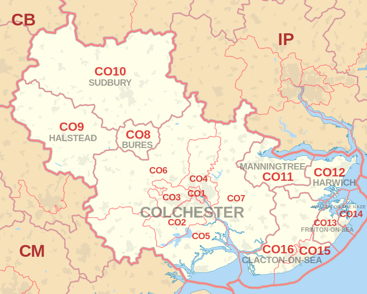 |
| Postcode |
Coverage Area |
Local Authority Area |
| CO1 |
Colchester |
Colchester |
| CO2 |
Colchester, Old Heath, Berechurch, Layer de la Haye |
Colchester |
| CO3 |
Colchester, Lexden, Stanway |
Colchester |
| CO4 |
Colchester, Myland, Boxted |
Colchester |
| CO5 |
Tiptree, Kelvedon, West Mersea, Peldon, Rowhedge |
Colchester, Braintree, Maldon |
| CO6 |
Coggeshall, Earls Colne, Marks Tey, Great Tey,
Chappel, Wakes Colne, Copford, West Bergholt,
Great Horkesley, Wormingford, Nayland, Stoke-by-Nayland, Polstead |
Colchester, Braintree, Babergh |
| CO7 |
Brightlingsea, Wivenhoe, Great Bentley |
Colchester, Tendring |
| CO8 |
Bures, Alphamstone |
Colchester, Braintree, Babergh |
| CO9 |
Halstead |
Braintree |
Total Sales By Postcode
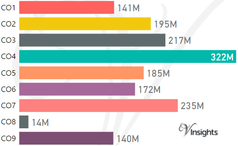
*M represents Million Pounds
Average & Median Sales Price By Postcode
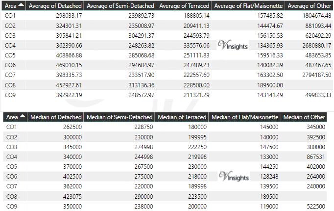
* Average and Medium Sales Price is in Pounds
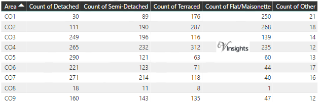
Total Number Of Sales By Postcode
Schools for Postcode Area CO
- CO Postcode Area - CO1, CO2, CO3, CO4, CO5, CO6, CO7, CO8, CO9 School Details
- CO Postcode Area - CO10, CO11, CO12, CO13, CO14, CO15, CO16 School Details
Other Property Posts for Postcode Area CO
All CO Postcodes Yearly & Trend Analysis Posts

Reference
CO Postcode Area As Per Wikipedia
bbfbce0e-090d-46fd-8128-0c59dd6ef642|0|.0|27604f05-86ad-47ef-9e05-950bb762570c