12. April 2018 22:55
/
VInsights Team
/
/
Comments (0)
Please click here for the updated version of this post
This Post covers
Coverage Area of Postcode CH41 to CH49
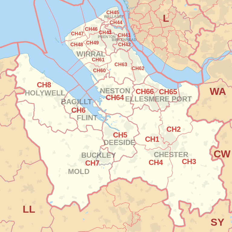 |
| Postcode |
Coverage Area |
Local Authority Area |
| CH41 |
Birkenhead, Claughton, Seacombe, Tranmere, Woodside |
Wirral |
| CH42 |
Birkenhead, Oxton, Prenton, Rock Ferry |
Wirral |
| CH43 |
Beechwood, Bidston, Noctorum, Oxton, Prenton |
Wirral |
| CH44 |
Egremont, Liscard, Poulton, Seacombe, Wallasey |
Wirral |
| CH45 |
New Brighton, Wallasey, Wallasey Village |
Wirral |
| CH46 |
Leasowe, Moreton |
Wirral |
| CH47 |
Hoylake, Meols, Saughall Massie, West Kirby |
Wirral |
| CH48 |
Caldy, Frankby, Grange, Greasby, Hoylake, Meols, Newton, West Kirby |
Wirral |
| CH49 |
Greasby, Landican, Saughall Massie, Upton, Woodchurch |
Wirral |
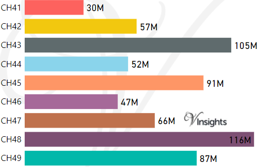
- M represents Million Pounds
- Total value includes Property Type Other apart from Detached, Semi-Detached, Terraced, Flat/Masionette
Schools for Postcode Area CH
- CH Postcode Area - CH1, CH2, CH3, CH4, CH5, CH6, CH7, CH8 School Details
- CH Postcode Area - CH41, CH42, CH43, CH44, CH45, CH46, CH47, CH48, CH49 School Details
- CH Postcode Area - CH60, CH61, CH62, CH63, CH64, CH65, CH66 School Details
Property Posts for Postcode Area CH
4eee121c-ae6d-4e0a-b480-f3ae6e39d8a0|0|.0|27604f05-86ad-47ef-9e05-950bb762570c
Tags :