17. September 2017 08:32
/
VInsights Team
/
Schools
/
Comments (0)
 This Post covers
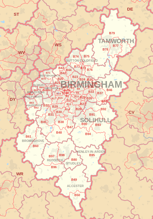
- Coverage Area of Postcode B30 to B38
- School Details for Postcode Area B30 to B38
- Other Schools for Postcode Area B
Coverage Area of Postcode B30 to B38
|
|
| Postcode |
Coverage Area |
Local Authority Area |
| B30 |
Bournville, Cotteridge, Stirchley |
Birmingham |
| B31 |
Northfield, Longbridge, West Heath |
Birmingham |
| B32 |
Woodgate, Bartley Green, Quinton, California (part of) |
Birmingham |
| B33 |
Kitts Green, Stechford |
Birmingham |
| B34 |
Shard End, Buckland End |
Birmingham |
| B35 |
Castle Vale |
Birmingham |
| B36 |
Castle Bromwich, Smith's Wood, Bromford, Hodge Hill |
Birmingham, Solihull |
| B37 |
Chelmsley Wood, Marston Green, Kingshurst, Fordbridge |
Solihull |
| B38 |
Kings Norton, West Heath |
Birmingham |
where *F.S. = Faith School, *PERF = Performance, *D.F.E.=Department For Education
Schools in Postcode B30
Schools in Postcode B31
Schools in Postcode B32
Schools in Postcode B33
Schools in Postcode B34
Schools in Postcode B35
Schools in Postcode B36
Schools in Postcode B37
Schools in Postcode B38
where *F.S. = Faith School, *PERF = Performance, *D.F.E.=Department For Education
Other Schools for Postcode Area B
- Birmingham B Postcode Area - B1, B2, B3, B4, B5, B6, B7, B8, B9 School Details
- Birmingham B Postcode Area - B10, B11, B12, B13, B14, B15, B16, B17, B18, B19 School Details
- Birmingham B Postcode Area - B20, B21, B23, B24, B25, B26, B27, B28, B29 School Details
- Birmingham B Postcode Area - B42, B43, B44, B45, B46, B47, B48, B49 School Details
- B Postcode Area - B50, B60, B61,B62, B63, B64, B65, B66, B67, B68, B69 School Details
- B Postcode Area - B70, B71, B72, B73, B74, B75, B76, B77, B78, B79 School Details
- B Postcode Area - B80, B90, B91,B92, B93, B94, B95, B96, B97, B98 School Details
All B Postcodes Yearly & Trend Analysis Posts

262f7090-f491-41bd-883e-7720b11338bc|0|.0|27604f05-86ad-47ef-9e05-950bb762570c
17. September 2017 08:24
/
VInsights Team
/
Schools
/
Comments (0)
 This Post covers
- Coverage Area of Postcode B20 to B29
- School Details for Postcode Area B20 to B29
- Other Schools for Postcode Area B
Coverage Area of Postcode B20 to B29
|
|
| Postcode |
Coverage Area |
Local Authority Area |
| B20 |
Handsworth Wood, Handsworth, Birchfield |
Birmingham |
| B21 |
Handsworth |
Birmingham |
| B23 |
Erdington, Stockland Green, Short Heath, Perry Common |
Birmingham |
| B24 |
Erdington, Wylde Green, Tyburn |
Birmingham |
| B25 |
Yardley |
Birmingham |
| B26 |
Sheldon, Yardley |
Birmingham |
| B27 |
Acocks Green |
Birmingham |
| B28 |
Hall Green |
Birmingham |
| B29 |
Selly Oak, Bournbrook, Selly Park, Weoley Castle, California (part of) |
Birmingham |
where *F.S. = Faith School, *PERF = Performance, *D.F.E.=Department For Education
Schools in Postcode B20
Schools in Postcode B21
Schools in Postcode B23
Schools in Postcode B24
Schools in Postcode B25
Schools in Postcode B26
Schools in Postcode B27
Schools in Postcode B28
Schools in Postcode B29
where *F.S. = Faith School, *PERF = Performance, *D.F.E.=Department For Education
Other Schools for Postcode Area B
- Birmingham B Postcode Area - B1, B2, B3, B4, B5, B6, B7, B8, B9 School Details
- Birmingham B Postcode Area - B10, B11, B12, B13, B14, B15, B16, B17, B18, B19 School Details
- Birmingham B Postcode Area - B30, B31,B32, B33, B34, B35, B36, B37, B38 School Details
- Birmingham B Postcode Area - B42, B43, B44, B45, B46, B47, B48, B49 School Details
- B Postcode Area - B50, B60, B61,B62, B63, B64, B65, B66, B67, B68, B69 School Details
- B Postcode Area - B70, B71, B72, B73, B74, B75, B76, B77, B78, B79 School Details
- B Postcode Area - B80, B90, B91,B92, B93, B94, B95, B96, B97, B98 School Details
All B Postcodes Yearly & Trend Analysis Posts
3d2354f1-2cbd-4163-85d8-eadbffdb391a|0|.0|27604f05-86ad-47ef-9e05-950bb762570c
17. September 2017 08:08
/
VInsights Team
/
Schools
/
Comments (0)
 This Post covers
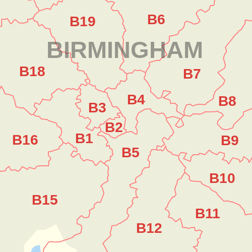
- Coverage Area of Postcode B10 to B19
- School Details for Postcode Area B10 to B19
- Other Schools for Postcode Area B
Coverage Area of Postcode B10 to B19
|
|
| Postcode |
Coverage Area |
Local Authority Area |
| B10 |
Small Heath |
Birmingham |
| B11 |
Sparkhill, Sparkbrook, Tyseley |
Birmingham |
| B12 |
Balsall Heath, Sparkbrook, Highgate |
Birmingham |
| B13 |
Moseley, Billesley |
Birmingham |
| B14 |
Kings Heath, Yardley Wood, Druids Heath, Highter's Heath, Warstock |
Birmingham |
| B15 |
Edgbaston, Lee Bank |
Birmingham |
| B16 |
Edgbaston, Ladywood |
Birmingham |
| B17 |
Harborne |
Birmingham |
| B18 |
Winson Green, Hockley |
Birmingham |
| B19 |
Lozells, Newtown, Birchfield |
Birmingham |
where *F.S. = Faith School, *PERF = Performance, *D.F.E.=Department For Education
Schools in Postcode B10
Schools in Postcode B11
Schools in Postcode B12
Schools in Postcode B13
Schools in Postcode B14
Schools in Postcode B15
Schools in Postcode B16
Schools in Postcode B17
Schools in Postcode B18
Schools in Postcode B19
where *F.S. = Faith School, *PERF = Performance, *D.F.E.=Department For Education
Other Schools for Postcode Area B
- Birmingham B Postcode Area - B1, B2, B3, B4, B5, B6, B7, B8, B9 School Details
- Birmingham B Postcode Area - B20, B21, B23, B24, B25, B26, B27, B28, B29 School Details
- Birmingham B Postcode Area - B30, B31,B32, B33, B34, B35, B36, B37, B38 School Details
- Birmingham B Postcode Area - B42, B43, B44, B45, B46, B47, B48, B49 School Details
- B Postcode Area - B50, B60, B61,B62, B63, B64, B65, B66, B67, B68, B69 School Details
- B Postcode Area - B70, B71, B72, B73, B74, B75, B76, B77, B78, B79 School Details
- B Postcode Area - B80, B90, B91,B92, B93, B94, B95, B96, B97, B98 School Details
All B Postcodes Yearly & Trend Analysis Posts
e0e9dbae-b41a-4570-816f-f6f79bd5402b|0|.0|27604f05-86ad-47ef-9e05-950bb762570c
16. September 2017 21:52
/
VInsights Team
/
Schools
/
Comments (0)

This Post covers
- Coverage Area of Postcode B1 to B9
- School Details for Postcode Area B1 to B9
- Other Schools for Postcode Area B
Coverage Area of Postcode B1 to B9
|
|
| Postcode |
Coverage Area |
Local Authority Area |
| B1 |
Birmingham City Centre, Broad Street (east) |
Birmingham |
| B2 |
Birmingham City Centre, New Street |
Birmingham |
| B3 |
Birmingham City Centre, Newhall Street |
Birmingham |
| B4 |
Birmingham City Centre, Corporation Street (north) |
Birmingham |
| B5 |
Digbeth, Highgate, Lee Bank |
Birmingham |
| B6 |
Aston, Witton |
Birmingham |
| B7 |
Nechells |
Birmingham |
| B8 |
Washwood Heath, Ward End, Saltley |
Birmingham |
| B9 |
Bordesley Green, Bordesley |
Birmingham |
where *F.S. = Faith School, *PERF = Performance, *D.F.E.=Department For Education
Schools in Postcode B1
Schools in Postcode B2
There are no schools
Schools in Postcode B3
Schools in Postcode B4
Schools in Postcode B5
Schools in Postcode B6
Schools in Postcode B7
Schools in Postcode B8
| School |
Postcode |
Phase |
Gender |
*F.S. |
Ofsted |
*PERF |
*D.F.E. |
Area |
| Adderley Primary School |
B8 1DZ |
Primary |
Mixed |
N |
Rating |
Details |
Data |
Birmingham |
| Adderley Nursery School |
B8 1EH |
Nursery |
Mixed |
N |
Rating |
Details |
Data |
Birmingham |
| St Saviour's C of E Primary School |
B8 1JB |
Primary |
Mixed |
Y |
Rating |
Details |
Data |
Birmingham |
| Al Huda Girls' School |
B8 1RD |
N/A |
Girls |
N |
Rating |
Details |
Data |
Birmingham |
| Washwood Heath Academy |
B8 2AS |
Secondary |
Mixed |
N |
Rating |
Details |
Data |
Birmingham |
| Thornton Primary School |
B8 2LQ |
Primary |
Mixed |
N |
Rating |
Details |
Data |
Birmingham |
| Ward End Community College |
B8 2LS |
N/A |
Girls |
N |
Rating |
Details |
Data |
Birmingham |
| St Cuthbert's RC Junior and Infant (NC) School |
B8 2PS |
Primary |
Mixed |
Y |
Rating |
Details |
Data |
Birmingham |
| Ward End Primary School |
B8 2RA |
Primary |
Mixed |
N |
Rating |
Details |
Data |
Birmingham |
| Washwood Heath Nursery School |
B8 2SY |
Nursery |
Mixed |
N |
Rating |
Details |
Data |
Birmingham |
| Sladefield Infant School |
B8 2TJ |
Primary |
Mixed |
N |
Rating |
Details |
Data |
Birmingham |
| Leigh Primary School |
B8 2YH |
Primary |
Mixed |
N |
Rating |
Details |
Data |
Birmingham |
| Shaw Hill Primary School |
B8 3AN |
Primary |
Mixed |
N |
Rating |
Details |
Data |
Birmingham |
| Parkfield Community School |
B8 3AX |
Primary |
Mixed |
N |
Rating |
Details |
Data |
Birmingham |
| Rockwood Academy |
B8 3HG |
Secondary |
Mixed |
N |
Rating |
Details |
Data |
Birmingham |
| Nansen Primary School |
B8 3HG |
Primary |
Mixed |
N |
Rating |
Details |
Data |
Birmingham |
| Highfield Junior and Infant School |
B8 3QF |
Primary |
Mixed |
N |
Rating |
Details |
Data |
Birmingham |
| Highfield Nursery School |
B8 3QU |
Nursery |
Mixed |
N |
Rating |
Details |
Data |
Birmingham |
| The Rosary Catholic Primary School |
B8 3SF |
Primary |
Mixed |
Y |
Rating |
Details |
Data |
Birmingham |
Schools in Postcode B9
where *F.S. = Faith School, *PERF = Performance, *D.F.E.=Department For Education
Other Schools for Postcode Area B
- Birmingham B Postcode Area - B10, B11, B12, B13, B14, B15, B16, B17, B18, B19 School Details
- Birmingham B Postcode Area - B20, B21, B23, B24, B25, B26, B27, B28, B29 School Details
- Birmingham B Postcode Area - B30, B31,B32, B33, B34, B35, B36, B37, B38 School Details
- Birmingham B Postcode Area - B42, B43, B44, B45, B46, B47, B48, B49 School Details
- B Postcode Area - B50, B60, B61,B62, B63, B64, B65, B66, B67, B68, B69 School Details
- B Postcode Area - B70, B71, B72, B73, B74, B75, B76, B77, B78, B79 School Details
- B Postcode Area - B80, B90, B91,B92, B93, B94, B95, B96, B97, B98 School Details
All B Postcodes Yearly & Trend Analysis Posts
225a7c09-8773-4fbf-bc51-d957171b3c5f|0|.0|27604f05-86ad-47ef-9e05-950bb762570c
16. September 2017 20:23
/
VInsights Team
/
Schools
/
Comments (0)

This Post covers
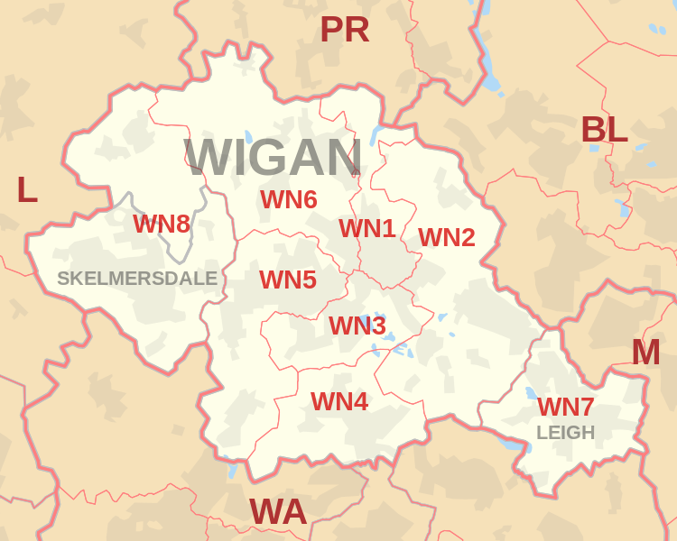
- Coverage Area of Postcode WN1 to WN9
- School Details for Postcode Area WN1 to WN9
- Property Market Posts for Postcode Area WN
Coverage Area of Postcode WN1 to WN8
 |
| Postcode |
Coverage Area |
Local Authority Area |
| WN1 |
Haigh, Ince, Swinley, Wigan |
Wigan |
| WN2 |
Abram, Aspull, Bamfurlong, Bickershaw, Haigh, Hindley, Hindley Green, Ince, Platt Bridge |
Wigan |
| WN3 |
Goose Green, Ince, Winstanley, Worsley Mesnes, Hawkley Hall |
Wigan |
| WN4 |
Ashton-in-Makerfield, Garswood |
Wigan, St Helens |
| WN5 |
Billinge, Newtown, Higher End, Orrell, Pemberton,
Winstanley, Worsley Hall, Marsh Green. |
Wigan, St Helens |
| WN6 |
Appley Bridge, Shevington, Standish, Standish Lower Ground, Wrightington |
Wigan, West Lancashire |
| WN7 |
Hope Carr, Landside, Leigh, Low Common, Bedford, Westleigh, Pennington, Higher Folds |
Wigan |
| WN8 |
Chapel House, Dalton, Holland Moor, Newburgh, Parbold,
Roby Mill, Skelmersdale, Southway, Upholland |
West Lancashire |
where *F.S. = Faith School, *PERF = Performance, *D.F.E.=Department For Education
Schools in Postcode WN1
Schools in Postcode WN2
Schools in Postcode WN3
Schools in Postcode WN4
Schools in Postcode WN5
Schools in Postcode WN6
Schools in Postcode WN7
Schools in Postcode WN8
where *F.S. = Faith School, *PERF = Performance, *D.F.E.=Department For Education
Property Market Posts for Postcode Area WN
All North West England Schools
9816f42a-2c3c-4f5b-9d34-ceb0e4bc5491|0|.0|27604f05-86ad-47ef-9e05-950bb762570c