17. September 2017 20:23
/
VInsights Team
/
Schools
/
Comments (0)
 This Post covers
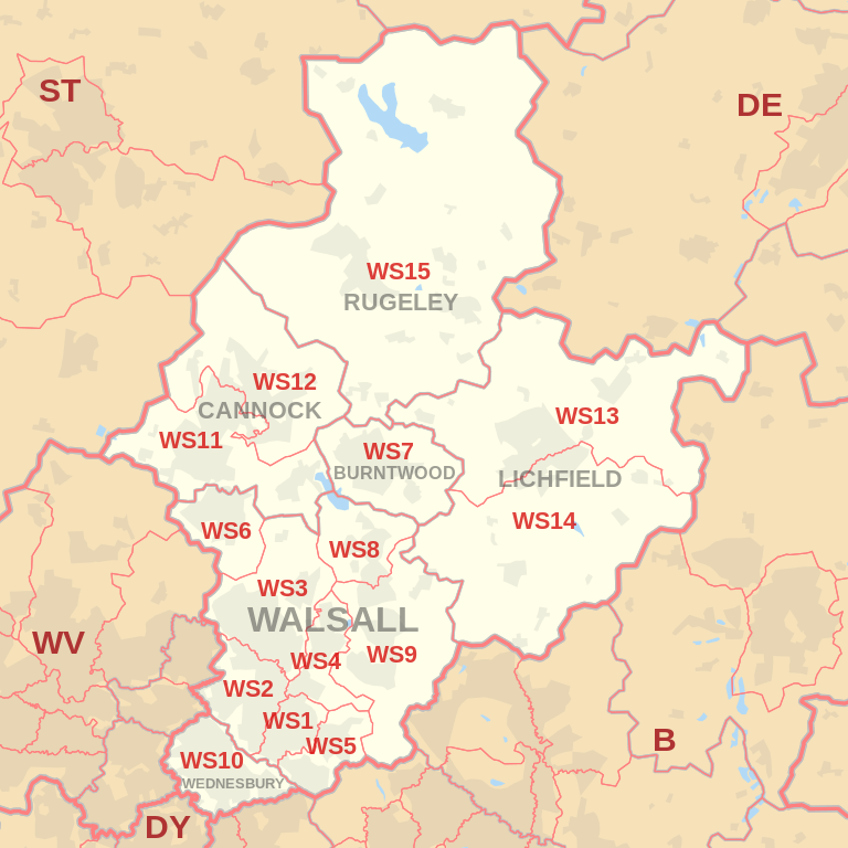
- Coverage Area of Postcode WS1 to WS9
- School Details for Postcode Area WS1 to WS9
- Other Schools for Postcode Area WS
Coverage Area of Postcode WS1 to WS9
|
|
| Postcode |
Coverage Area |
Local Authority Area |
| WS1 |
Walsall town centre, Caldmore |
Walsall |
| WS2 |
Pleck, Bentley, Leamore |
Walsall |
| WS3 |
Bloxwich, Coal Pool, Pelsall |
Walsall |
| WS4 |
Rushall |
Walsall |
| WS5 |
Bescot, Tamebridge, Yew Tree |
Walsall |
| WS6 |
Cheslyn Hay, Great Wyrley |
South Staffordshire |
| WS7 |
Burntwood |
Lichfield |
| WS8 |
Brownhills, Walsall Wood (north) |
Walsall |
| WS9 |
Aldridge, Walsall Wood (south), Stonnall |
Walsall, Lichfield |
where *F.S. = Faith School, *PERF = Performance, *D.F.E.=Department For Education
Schools in Postcode WS1
Schools in Postcode WS2
Schools in Postcode WS3
Schools in Postcode WS4
Schools in Postcode WS5
Schools in Postcode WS6
Schools in Postcode WS7
Schools in Postcode WS8
Schools in Postcode WS9
where *F.S. = Faith School, *PERF = Performance, *D.F.E.=Department For Education
Other Schools for Postcode Area WS
All WS Postcodes Yearly & Trend Analysis Posts

f18da8be-29f8-4c23-b485-ab41b36088e8|0|.0|27604f05-86ad-47ef-9e05-950bb762570c
17. September 2017 20:14
/
VInsights Team
/
Schools
/
Comments (0)
 This Post covers
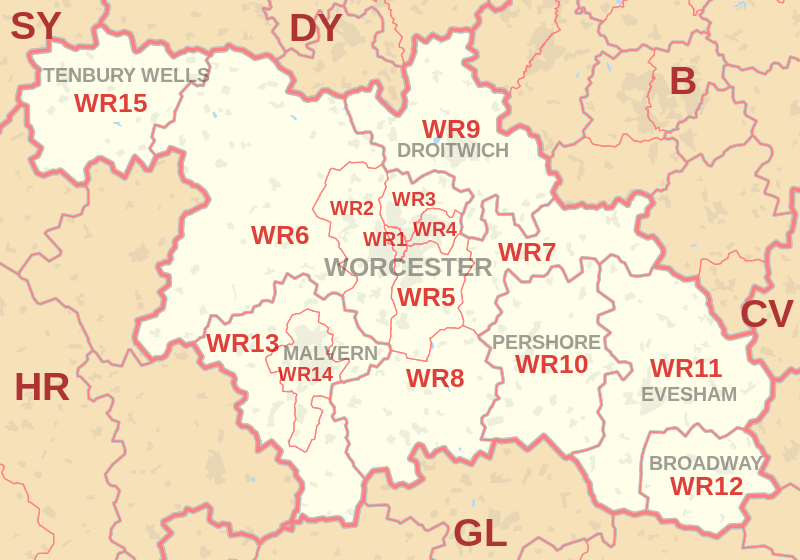
- Coverage Area of Postcode WR10 to WR15
- School Details for Postcode Area WR10 to WR15
- Other Schools for Postcode Area WR
Coverage Area of Postcode WR10 to WR15
|
|
| Postcode |
Coverage Area |
Local Authority Area |
| WR10 |
Pershore, Eckington, Drakes Broughton |
Wychavon |
| WR11 |
Evesham, Harvington, Badsey |
Wychavon, Stratford-on-Avon, Tewkesbury, Cotswold |
| WR12 |
Broadway, Willersey, Childswickham |
Wychavon, Tewkesbury, Cotswold |
| WR13 |
Colwall, Cradley, Welland |
Malvern Hills, Herefordshire, Forest of Dean |
| WR14 |
Malvern, Upper Welland |
Malvern Hills, Herefordshire |
| WR15 |
Tenbury Wells, Burford, Newnham Bridge |
Malvern Hills, Shropshire, Herefordshire |
where *F.S. = Faith School, *PERF = Performance, *D.F.E.=Department For Education
Schools in Postcode WR10
Schools in Postcode WR11
Schools in Postcode WR12
Schools in Postcode WR13
Schools in Postcode WR14
Schools in Postcode WR15
where *F.S. = Faith School, *PERF = Performance, *D.F.E.=Department For Education
Other Schools for Postcode Area WR
All WR Postcodes Yearly & Trend Analysis Posts
54588a81-2f92-49d2-9db1-00ec64809c7f|0|.0|27604f05-86ad-47ef-9e05-950bb762570c
17. September 2017 20:05
/
VInsights Team
/
Schools
/
Comments (0)
 This Post covers
- Coverage Area of Postcode WR1 to WR9
- School Details for Postcode Area WR1 to WR9
- Other Schools for Postcode Area WR
Coverage Area of Postcode WR1 to WR9
|
|
| Postcode |
Coverage Area |
Local Authority Area |
| WR1 |
Worcester |
Worcester |
| WR2 |
Powick, Hallow |
Worcester, Malvern Hills |
| WR3 |
Fernhill Heath, Claines |
Worcester, Wychavon |
| WR4 |
Warndon, Long Meadow |
Worcester, Wychavon |
| WR5 |
Kempsey, Broomhall |
Worcester, Wychavon, Malvern Hills |
| WR6 |
Martley, Clifton on Teme, Abberley |
Malvern Hills, Herefordshire |
| WR7 |
Inkberrow, Crowle, Upton Snodsbury |
Wychavon |
| WR8 |
Upton upon Severn, Hanley Castle, Hanley Swan |
Malvern Hills, Wychavon |
| WR9 |
Droitwich, Ombersley, Wychbold |
Wychavon, Wyre Forest |
where *F.S. = Faith School, *PERF = Performance, *D.F.E.=Department For Education
Schools in Postcode WR1
Schools in Postcode WR2
Schools in Postcode WR3
Schools in Postcode WR4
Schools in Postcode WR5
Schools in Postcode WR6
Schools in Postcode WR7
Schools in Postcode WR8
Schools in Postcode WR9
where *F.S. = Faith School, *PERF = Performance, *D.F.E.=Department For Education
Other Schools for Postcode Area WR
All WR Postcodes Yearly & Trend Analysis Posts
93e3ea8b-4a9d-49c4-bcd5-bf817b95b186|0|.0|27604f05-86ad-47ef-9e05-950bb762570c
17. September 2017 19:59
/
VInsights Team
/
Schools
/
Comments (0)
 This Post covers
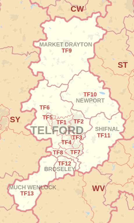
- Coverage Area of Postcode TF10 to TF13
- School Details for Postcode Area TF10 to TF13
- Other Schools for Postcode Area TF
Coverage Area of Postcode TF10 to TF13
|
|
| Postcode |
Coverage Area |
Local Authority Area |
| TF10 |
Newport, Lilleshall, Edgmond, Moreton |
Telford & Wrekin, Stafford |
| TF11 |
Shifnal, Tong, Weston-under-Lizard |
Shropshire, South Staffordshire |
| TF12 |
Broseley |
Shropshire |
| TF13 |
Much Wenlock |
Shropshire |
where *F.S. = Faith School, *PERF = Performance, *D.F.E.=Department For Education
Schools in Postcode TF10
Schools in Postcode TF11
Schools in Postcode TF12
Schools in Postcode TF13
where *F.S. = Faith School, *PERF = Performance, *D.F.E.=Department For Education
Other Schools for Postcode Area TF
All TF Postcodes Yearly & Trend Analysis Posts
efa8e865-be09-46a2-9543-6a26adbe4dc0|0|.0|27604f05-86ad-47ef-9e05-950bb762570c
17. September 2017 19:46
/
VInsights Team
/
Schools
/
Comments (0)
 This Post covers
- Coverage Area of Postcode TF1 to TF9
- School Details for Postcode Area TF1 to TF9
- Other Schools for Postcode Area TF
- Property Market Posts for Postcode Area TF
Coverage Area of Postcode TF1 to TF9
|
|
| Postcode |
Coverage Area |
Local Authority Area |
| TF1 |
Wellington, Leegomery, Hadley, Ketley, Arleston, Hortonwood |
Telford & Wrekin |
| TF2 |
Oakengates, Priorslee, St. Georges, Donnington, Wrockwardine Wood, Muxton |
Telford & Wrekin |
| TF3 |
Telford Town Centre and Park, Hollinswood, Randlay, Stirchley, Brookside, Stafford Park |
Telford & Wrekin |
| TF4 |
Dawley, Malinslee, Lawley, Horsehay |
Telford & Wrekin |
| TF5 |
Admaston, Bratton, Shawbirch |
Telford & Wrekin |
| TF6 |
The Wrekin, Wrockwardine, Longden-upon-Tern, High Ercall |
Telford & Wrekin |
| TF7 |
Madeley, Woodside, Sutton Hill, Halesfield |
Telford & Wrekin |
| TF8 |
Ironbridge, Coalbrookdale, Coalport, Jackfield |
Telford & Wrekin |
| TF9 |
Market Drayton, Loggerheads, Hodnet, Ternhill |
Telford & Wrekin
Wolverhampton |
where *F.S. = Faith School, *PERF = Performance, *D.F.E.=Department For Education
Schools in Postcode TF1
Schools in Postcode TF2
Schools in Postcode TF3
Schools in Postcode TF4
Schools in Postcode TF5
Schools in Postcode TF6
Schools in Postcode TF7
Schools in Postcode TF8
Schools in Postcode TF9
where *F.S. = Faith School, *PERF = Performance, *D.F.E.=Department For Education
Other Schools for Postcode Area TF
All TF Postcodes Yearly & Trend Analysis Posts
991119d7-ca7f-4fad-b967-0050532dc4b3|0|.0|27604f05-86ad-47ef-9e05-950bb762570c