27. April 2018 13:45
/
VInsights Team
/
/
Comments (0)
Please click here for the updated version of this post
This Post covers
Coverage Area of Postcode CF3 to CF15
|
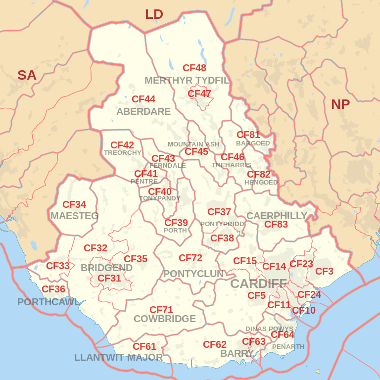
|
| Postcode |
Coverage Area |
Local Authority Area |
| CF3 |
CARDIFF SOUTH (East):Rumney & Trowbridge, Llanrumney, St Mellons
NEWPORT WEST: Castleton, Marshfield |
Cardiff, Newport |
| CF5 |
CARDIFF WEST (South):Ely, Caerau, St Fagans, Culverhouse Cross, Canton & Leckwith, Fairwater, Danescourt, Llandaff, Riverside
VALE OF GLAMORGAN:Wenvoe, Peterston Super Ely, St Georges Super Ely, Michaelston
|
Cardiff, Vale of Glamorgan |
| CF10 |
CARDIFF CENTRAL / CARDIFF SOUTH:CARDIFF CITY CENTRE (part of), Grangetown, CARDIFF BAY (part of) & Butetown |
Cardiff |
| CF11 |
CARDIFF CENTRAL / CARDIFF SOUTH:CARDIFF CITY CENTRE (part of), Canton, CARDIFF BAY (part of), Grangetown |
Cardiff |
| CF14 |
CARDIFF NORTH (West):Birchgrove, Whitchurch, Thornhill & Lisvane, Rhiwbina & Pantmawr, Gabalfa, Heath, Llandaff North, Llanishen |
Cardiff |
| CF15 |
CARDIFF WEST (North):Pentyrch & Gwaelod-y-Garth & Creigiau, Radyr & Morganstown, Tongwynlais
Rhondda Cynon Taff:TAFFS WELL & Nantgarw
Caerphilly:Groeswen
|
Cardiff, Rhondda Cynon Taff, Caerphilly |
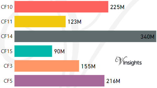
- M represents Million Pounds
- Total value includes Property Type Other apart from Detached, Semi-Detached, Terraced, Flat/Masionette
Property Posts for Postcode Area CF
90a8b5cc-85b7-4f22-9bdb-dcf747957e92|0|.0|27604f05-86ad-47ef-9e05-950bb762570c
Tags :