
This Post covers
- Coverage Area of Postcode DA10 to DA18
- School Details for Postcode Area DA10 to DA18
- Other Schools for Postcode Area DA
- Property Posts for Postcode Area DA
Coverage Area of Postcode DA10 to DA18
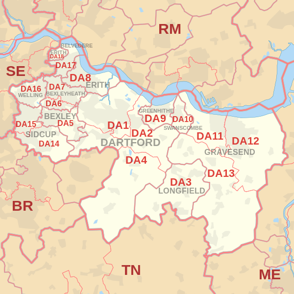 |
| Postcode |
Coverage Area |
Local Authority Area |
| DA10 |
Swanscombe, Ebbsfleet |
Dartford |
| DA11 |
Gravesend (west), Northfleet |
Dartford, Gravesham |
| DA12 |
Gravesend (east), Chalk, Shorne, Cobham |
Gravesham |
| DA13 |
Meopham, Istead Rise, Vigo, Southfleet |
Dartford, Gravesham, Sevenoaks, Tonbridge and Malling |
| DA14 |
Sidcup, Foots Cray, North Cray, Longlands, Ruxley, part of Albany Park |
Bexley, Bromley |
| DA15 |
Sidcup (north), Blackfen, Lamorbey, Longlands |
Bexley, Greenwich |
| DA16 |
Welling, Falconwood, East Wickham |
Bexley, Greenwich |
| DA17 |
Belvedere, Lessness Heath |
Bexley |
| DA18 |
Erith Marshes, Thamesmead (part) |
Bexley |
where *F.S. = Faith School, *PERF = Performance, *D.F.E.=Department For Education
Schools in Postcode DA10
| School |
Postcode |
Phase |
Gender |
*F.S. |
Ofsted |
*PERF |
*D.F.E. |
Area |
| Manor Community Primary School |
DA10 0BU |
Primary |
Mixed |
N |
Rating |
Details |
Data |
Kent |
| The Ebbsfleet Academy |
DA10 0BZ |
Secondary |
Mixed |
N |
Rating |
Details |
Data |
Kent |
| The Craylands School |
DA10 0LP |
Primary |
Mixed |
N |
Rating |
Details |
Data |
Kent |
Schools in Postcode DA11
Schools in Postcode DA12
Schools in Postcode DA13
Schools in Postcode DA14
| School |
Postcode |
Phase |
Gender |
*F.S. |
Ofsted |
*PERF |
*D.F.E. |
Area |
| Birkbeck Primary School |
DA14 4ED |
Primary |
Mixed |
N |
Rating |
Details |
Data |
Bexley |
| Cleeve Park School |
DA14 4JN |
Secondary |
Mixed |
N |
Rating |
Details |
Data |
Bexley |
| Royal Park Primary School |
DA14 4PX |
Primary |
Mixed |
N |
Rating |
Details |
Data |
Bexley |
| Merton Court School |
DA14 4QU |
N/A |
Mixed |
Y |
Rating |
Details |
Data |
Bexley |
| Kemnal Technology College |
DA14 5AA |
Secondary |
Boys |
N |
Rating |
Details |
Data |
Bromley |
| Hope Community School |
DA14 5BU |
Primary |
Mixed |
Y |
Rating |
Details |
Data |
Bexley |
| St Peter Chanel Catholic Primary School |
DA14 5ED |
Primary |
Mixed |
Y |
Rating |
Details |
Data |
Bexley |
| Orchard Primary School |
DA14 6LW |
Primary |
Mixed |
N |
Rating |
Details |
Data |
Bexley |
Schools in Postcode DA15
Schools in Postcode DA16
Schools in Postcode DA17
Schools in Postcode DA18
| School |
Postcode |
Phase |
Gender |
*F.S. |
Ofsted |
*PERF |
*D.F.E. |
Area |
| St John Fisher Catholic Primary School |
DA18 4BA |
Primary |
Mixed |
Y |
Rating |
Details |
Data |
Bexley |
| Parkway Primary School |
DA18 4DP |
Primary |
Mixed |
N |
Rating |
Details |
Data |
Bexley |
| The Business Academy Bexley |
DA18 4DW |
All Through |
Mixed |
N |
Rating |
Details |
Data |
Bexley |
| Northwood Primary School |
DA18 4HN |
Primary |
Mixed |
N |
Rating |
Details |
Data |
Bexley |
where *F.S. = Faith School, *PERF = Performance, *D.F.E.=Department For Education
Other Schools for Postcode Area DA
Property Posts for Postcode Area DA
All DA Postcodes Yearly & Trend Analysis Posts

d0238d37-6e81-4ea6-8944-67cdbc358adc|0|.0|27604f05-86ad-47ef-9e05-950bb762570c

This Post covers
- Coverage Area of Postcode DA1 to DA9
- School Details for Postcode Area DA1 to DA9
- Other Schools for Postcode Area DA
- Multi Year Property Trend Analysis By Postcode DA1 to DA9
- Posts for Postcode Area DA
Coverage Area of Postcode DA1 to DA9
|
| Postcode |
Coverage Area |
Local Authority Area |
| DA1 |
Dartford, Crayford, Barnes Cray |
Bexley, Dartford |
| DA2 |
Dartford (east), Stone, Wilmington, Bean, Hawley, Darenth, part of Joyden's Wood |
Dartford, Sevenoaks |
| DA3 |
Longfield, Hartley, New Ash Green, New Barn, Fawkham |
Dartford, Gravesham, Sevenoaks |
| DA4 |
Farningham, Eynsford, South Darenth, Sutton-at-Hone, Horton Kirby |
Dartford, Sevenoaks |
| DA5 |
Bexley, parts of Albany Park and Joyden's Wood |
Bexley, Dartford |
| DA6 |
Bexleyheath, Upton |
Bexley |
| DA7 |
Bexleyheath (north), Barnehurst |
Bexley |
| DA8 |
Erith, Northumberland Heath, Slade Green |
Bexley |
| DA9 |
Greenhithe, Stone |
Dartford |
where *F.S. = Faith School, *PERF = Performance, *D.F.E.=Department For Education
Schools in Postcode DA1
Schools in Postcode DA2
Schools in Postcode DA3
Schools in Postcode DA4
Schools in Postcode DA5
Schools in Postcode DA6
Schools in Postcode DA7
Schools in Postcode DA8
Schools in Postcode DA9
| School |
Postcode |
Phase |
Gender |
*F.S. |
Ofsted |
*PERF |
*D.F.E. |
Area |
| Stone St Mary's CofE Primary School |
DA9 9EF |
Primary |
Mixed |
Y |
Rating |
Details |
Data |
Kent |
| Knockhall Academy |
DA9 9RF |
Primary |
Mixed |
N |
Rating |
Details |
Data |
Kent |
where *F.S. = Faith School, *PERF = Performance, *D.F.E.=Department For Education
Other Schools for Postcode Area DA
Multi Year Property Trend Analysis By Postcode
Posts for Postcode Area DA
All DA Postcodes Yearly & Trend Analysis Posts
d15cfa58-dc18-4b78-a909-464b4ef2fd04|0|.0|27604f05-86ad-47ef-9e05-950bb762570c

This Post covers
- Coverage Area of Postcode CR0 to CR9
- School Details for Postcode Area CR0 to CR9
- Multi Year Property Trend Analysis By Postcode CR0 to CR9
- Property Posts for Postcode Area CR
Coverage Area of Postcode CR0 to CR8
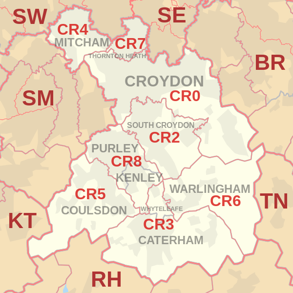 |
| Postcode |
Coverage Area |
Local Authority Area |
| CR0 |
Croydon, Addiscombe, Woodside (part), Selhurst, Broad Green, Spring Park, Shirley, Addington, New Addington, Coombe, Forestdale, Waddon, Beddington, Thornton Heath (part) |
Croydon, Sutton |
| CR2 |
South Croydon, Sanderstead, Selsdon, part of Addington |
Croydon, Sutton |
| CR3 |
Caterham, Chaldon, Woldingham, Whyteleafe, Hamsey Green |
Tandridge, Croydon |
| CR4 |
Mitcham, Mitcham Common, Pollards Hill, Eastfields, Beddington Corner |
Merton, Sutton, Croydon |
| CR5 |
Coulsdon, Old Coulsdon, Chipstead, Hooley, Netherne-on-the-Hill, part of Woodmansterne, Clockhouse |
Croydon, Reigate and Banstead, Sutton |
| CR6 |
Warlingham, parts of Chelsham and Farleigh, Hamsey Green |
Tandridge, Croydon, Bromley |
| CR7 |
Thornton Heath, Broad Green (part) |
Croydon, Merton |
| CR8 |
Purley, Kenley, Russell Hill |
Croydon, Sutton, Tandridge |
| CR9 |
Shirley |
Croydon |
where *F.S. = Faith School, *PERF = Performance, *D.F.E.=Department For Education
Schools in Postcode CR0
Schools in Postcode CR2
Schools in Postcode CR3
Schools in Postcode CR4
Schools in Postcode CR5
Schools in Postcode CR6
Schools in Postcode CR7
Schools in Postcode CR8
Schools in Postcode CR9
| School |
Postcode |
Phase |
Gender |
*F.S. |
Ofsted |
*PERF |
*D.F.E. |
Area |
| St Mary's Catholic High School |
CR9 2EE |
Secondary |
Mixed |
Y |
Rating |
Details |
Data |
Croydon |
| The Archbishop Lanfranc Academy |
CR9 3AS |
Secondary |
Mixed |
N |
Rating |
Details |
Data |
Croydon |
| Coloma Convent Girls' School |
CR9 5AS |
Secondary |
Girls |
Y |
Rating |
Details |
Data |
Croydon |
| Royal Russell School |
CR9 5BX |
N/A |
Mixed |
N |
Rating |
Details |
Data |
Croydon |
| Oasis Academy Shirley Park |
CR9 7AL |
All Through |
Mixed |
Y |
Rating |
Details |
Data |
Croydon |
| Trinity School |
CR9 7AT |
N/A |
Mixed |
N |
Rating |
Details |
Data |
Croydon |
where *F.S. = Faith School, *PERF = Performance, *D.F.E.=Department For Education
Multi Year Property Trend Analysis By Postcode
Property Posts for Postcode Area CR
All CR Postcodes Yearly & Trend Analysis Posts
0bdd5c32-6ede-4e6c-ba79-e3417c7bc6c3|0|.0|27604f05-86ad-47ef-9e05-950bb762570c

This Post covers
- Coverage Area of Postcode BR1 to BR8
- School Details for Postcode Area BR1 to BR8
- Multi Year Property Trend Analysis By Postcode BR1 to BR8
- Property Posts for Postcode Area BR
Coverage Area of Postcode BR1 to BR8
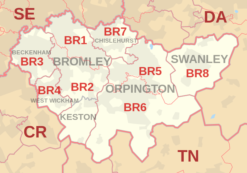 |
| Postcode |
Coverage Area |
Local Authority Area |
| BR1 |
Bromley, Bickley, Downham, Sundridge |
Bromley, Lewisham |
| BR2 |
Hayes, Shortlands, Bickley, Bromley Common, Keston |
Bromley |
| BR3 |
Beckenham, Elmers End, Shortlands, Eden Park, Park Langley |
Bromley, Lewisham, Croydon |
| BR4 |
West Wickham |
Bromley |
| BR5 |
Petts Wood, St Mary Cray, St Paul's Cray, Ruxley |
Bromley |
| BR6 |
Orpington, Locksbottom, Farnborough, Green Street Green, Chelsfield, Downe, Pratt's Bottom, Well Hill |
Bromley, Bexley, Sevenoaks |
| BR7 |
Chislehurst, Elmstead |
Bromley, Greenwich |
| BR8 |
Swanley, Hextable, Crockenhill, Swanley Village |
Sevenoaks, Bromley, Dartford |
where *F.S. = Faith School, *PERF = Performance, *D.F.E.=Department For Education
Schools in Postcode BR1
Schools in Postcode BR2
Schools in Postcode BR3
Schools in Postcode BR4
Schools in Postcode BR5
Schools in Postcode BR6
Schools in Postcode BR7
Schools in Postcode BR8
where *F.S. = Faith School, *PERF = Performance, *D.F.E.=Department For Education
Multi Year Property Trend Analysis By Postcode
Property Posts for Postcode Area BR
All BR Postcode Area Yearly & Trend Analysis Posts
ff3e3c81-b0cd-415a-b290-73586c68614d|0|.0|27604f05-86ad-47ef-9e05-950bb762570c

This Post covers
- Coverage Area of Postcode EN7 to EN11
- School Details for Postcode Area EN7 to EN11
- Other Schools for Postcode Area EN
- Property Posts for Postcode Area EN
Coverage Area of Postcode EN7 to EN11
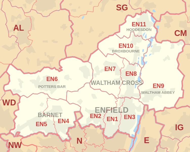 |
| Postcode |
Coverage Area |
Local Authority Area |
| EN7 |
Cheshunt, Goffs Oak, Some parts of Enfield |
Broxbourne, Enfield |
| EN8 |
Waltham Cross, Cheshunt, Some parts of Enfield |
Broxbourne, Enfield |
| EN9 |
Waltham Abbey, Nazeing, Upshire |
Epping Forest |
| EN10 |
Broxbourne, Wormley, Turnford |
Broxbourne, Epping Forest |
| EN11 |
Hoddesdon, Dobbs Weir |
Broxbourne, Epping Forest |
where *F.S. = Faith School, *PERF = Performance, *D.F.E.=Department For Education
Schools in Postcode EN7
Schools in Postcode EN8
Schools in Postcode EN9
Schools in Postcode EN10
| School |
Postcode |
Phase |
Gender |
*F.S. |
Ofsted |
*PERF |
*D.F.E. |
Area |
| Longlands Primary School and Nursery |
EN10 6AG |
Primary |
Mixed |
N |
Rating |
Details |
Data |
Hertfordshire |
| Wormley Primary School |
EN10 6QA |
Primary |
Mixed |
Y |
Rating |
Details |
Data |
Hertfordshire |
| Broxbourne CofE Primary School |
EN10 7AY |
Primary |
Mixed |
Y |
Rating |
Details |
Data |
Hertfordshire |
| The Broxbourne School |
EN10 7DD |
Secondary |
Mixed |
N |
Rating |
Details |
Data |
Hertfordshire |
Schools in Postcode EN11
| School |
Postcode |
Phase |
Gender |
*F.S. |
Ofsted |
*PERF |
*D.F.E. |
Area |
| Rivers Education Support Centre |
EN11 0AA |
N/A |
Mixed |
N |
Rating |
Details |
Data |
Hertfordshire |
| Rye Park Nursery School |
EN11 0LN |
Nursery |
Mixed |
N |
Rating |
Details |
Data |
Hertfordshire |
| The John Warner School |
EN11 0QF |
Secondary |
Mixed |
N |
Rating |
Details |
Data |
Hertfordshire |
| Forres Primary School |
EN11 0RW |
Primary |
Mixed |
N |
Rating |
Details |
Data |
Hertfordshire |
| St Cross Catholic Primary School |
EN11 8BN |
Primary |
Mixed |
Y |
Rating |
Details |
Data |
Hertfordshire |
| St Augustine's Catholic Primary School |
EN11 8DP |
Primary |
Mixed |
Y |
Rating |
Details |
Data |
Hertfordshire |
| St Catherine's Hoddesdon CofE Primary School |
EN11 8HT |
Primary |
Mixed |
N |
Rating |
Details |
Data |
Hertfordshire |
| Robert Barclay Academy |
EN11 8JY |
Secondary |
Mixed |
N |
Rating |
Details |
Data |
Hertfordshire |
| Sheredes Primary School |
EN11 8LL |
Primary |
Mixed |
N |
Rating |
Details |
Data |
Hertfordshire |
| Westfield Community Primary School |
EN11 8RA |
Primary |
Mixed |
N |
Rating |
Details |
Data |
Hertfordshire |
| Roselands Primary School |
EN11 9AR |
Primary |
Mixed |
N |
Rating |
Details |
Data |
Hertfordshire |
| The Cranbourne Primary School |
EN11 9PP |
Primary |
Mixed |
N |
Rating |
Details |
Data |
Hertfordshire |
where *F.S. = Faith School, *PERF = Performance, *D.F.E.=Department For Education
Other Schools for Postcode Area EN
Property Posts for Postcode Area EN
All EN Postcodes Yearly & Trend Analysis Posts
40ce82db-8fa3-4e91-875a-d444209adb75|0|.0|27604f05-86ad-47ef-9e05-950bb762570c