24. April 2018 12:37
/
VInsights Team
/
/
Comments (0)
Please click here for the updated version of this post
This Post covers
Coverage Area of Postcode S20 to S36
|
|
| Postcode |
Coverage Area |
Local Authority Area |
| S20 |
Beighton, Crystal Peaks, Halfway, Mosborough, Owlthorpe, Sothall, Waterthorpe, Westfield |
Sheffield |
| S21 |
Eckington, Killamarsh, Renishaw, Spinkhill |
North East Derbyshire |
| S25 |
Anston, Dinnington, Laughton-en-le-Morthen |
Rotherham |
| S26 |
Aston, Aughton, Harthill, Kiveton Park, Swallownest, Todwick, Wales |
Rotherham |
| S32 |
Calver, Eyam, Grindleford, Hathersage, Stoney Middleton |
Derbyshire Dales |
| S33 |
Bamford, Bradwell, Castleton, Edale, Hope, Yorkshire Bridge |
High Peak |
| S35 |
Chapeltown, Crane Moor, Ecclesfield, Grenoside, High Green, Oughtibridge, Thurgoland, Wharncliffe Side, Wortley |
Sheffield |
| S36 |
Penistone, Thurlstone, Millhouse Green, Oxspring, Stocksbridge, Deepcar Bolsterston |
Barnsley, Sheffield |
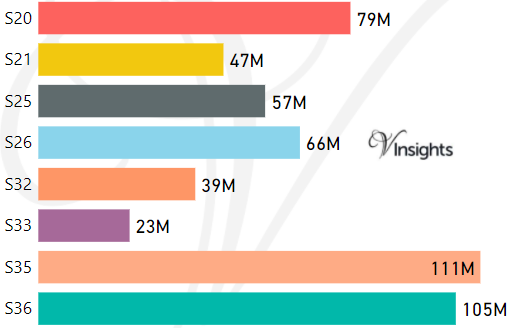
- M represents Million Pounds
- Total value includes Property Type Other apart from Detached, Semi-Detached, Terraced, Flat/Masionette
Schools for Postcode Area S
- Sheffield S Postcode Area - S1, S2, S3, S4, S5, S6, S7, S8, S9 School Details
- S Postcode Area - S10, S11, S12, S13, S14, S17, S18 School Details
- S Postcode Area - S20, S21, S25, S26, S32, S33, S35, S36 School Details
- S Postcode Area - S40, S41, S42, S43, S44, S45 School Details
- S Postcode Area - S60, S61, S62, S63, S64, S65, S66 School Details
- S Postcode Area - S70, S71, S72, S73, S74, S75, S80, S81 School Details
Property Posts for Postcode Area S
94bd5f89-e72c-42a3-b171-8912bc6b89f5|0|.0|27604f05-86ad-47ef-9e05-950bb762570c
Tags :
24. April 2018 09:21
/
VInsights Team
/
/
Comments (0)
Please click here for the updated version of this post
This Post covers
Coverage Area of Postcode S10 to S18
|
|
| Postcode |
Coverage Area |
Local Authority Area |
| S10 |
Broomhill, Broomhall, Crookes, Crookesmoor, Crosspool, Fulwood, Ranmoor |
Sheffield |
| S11 |
Ecclesall, Endcliffe Park, Ecclesall Road, Greystones, Hunter's Bar, Millhouses, Sharrow Vale, Nether Edge, Whirlow, Brincliffe |
Sheffield |
| S12 |
Birley, Gleadless, Gleadless Townend, Frecheville, Hackenthorpe, Intake, Ridgeway |
North East Derbyshire,
Sheffield |
| S13 |
Fence, Handsworth, Richmond, Woodhouse |
Rotherham,
Sheffield |
| S14 |
Gleadless Valley |
Sheffield |
| S17 |
Dore, Totley, Bradway |
Sheffield |
| S18 |
Coal Aston, Dronfield, Dronfield Woodhouse, Holmesfield, Unstone |
Sheffield |
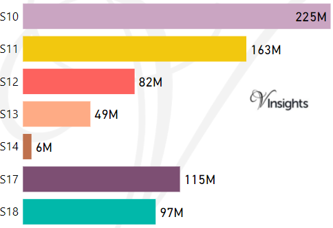
- M represents Million Pounds
- Total value includes Property Type Other apart from Detached, Semi-Detached, Terraced, Flat/Masionette
Schools for Postcode Area S
- Sheffield S Postcode Area - S1, S2, S3, S4, S5, S6, S7, S8, S9 School Details
- S Postcode Area - S10, S11, S12, S13, S14, S17, S18 School Details
- S Postcode Area - S20, S21, S25, S26, S32, S33, S35, S36 School Details
- S Postcode Area - S40, S41, S42, S43, S44, S45 School Details
- S Postcode Area - S60, S61, S62, S63, S64, S65, S66 School Details
- S Postcode Area - S70, S71, S72, S73, S74, S75, S80, S81 School Details
Property Posts for Postcode Area S
c475d671-d3fd-44c7-9e33-743e6f55994f|0|.0|27604f05-86ad-47ef-9e05-950bb762570c
Tags :
23. April 2018 20:41
/
VInsights Team
/
/
Comments (0)
Please click here for the updated version of this post
This Post covers
Coverage Area of Postcode S1 to S9
|
|
| Postcode |
Coverage Area |
Local Authority Area |
| S1 |
Sheffield City Centre |
Sheffield |
| S2 |
Arbourthorne, Heeley, Highfield, Manor, Norfolk Park, Wybourn, Park Hill |
Sheffield |
| S3 |
Broomhall, Burngreave, Neepsend, Netherthorpe |
Sheffield |
| S4 |
Grimesthorpe, Pitsmoor |
Sheffield |
| S5 |
Firth Park, Fir Vale, Longley, Shirecliffe, Shiregreen, Southey Green, Parson Cross |
Sheffield |
| S6 |
Bradfield, Dungworth, Hillsborough, Holdworth, Hollow Meadows, Loxley, Malin Bridge, Middlewood, Stannington, Storrs, Upperthorpe, Walkley, Wadsley Bridge, Wisewood, Wadsley, Fox Hill |
Sheffield |
| S7 |
Abbeydale, Carter Knowle, Nether Edge, Millhouses |
Sheffield |
| S8 |
Batemoor, Beauchief, Greenhill, Jordanthorpe, Lowedges, Meersbrook, Norton, Norton Lees, Woodseats |
Sheffield |
| S9 |
Attercliffe, Brightside, Darnall, Meadowhall, Tinsley, Wincobank |
Sheffield |
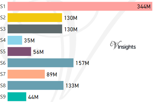
- M represents Million Pounds
- Total value includes Property Type Other apart from Detached, Semi-Detached, Terraced, Flat/Masionette
Schools for Postcode Area S
- Sheffield S Postcode Area - S1, S2, S3, S4, S5, S6, S7, S8, S9 School Details
- S Postcode Area - S10, S11, S12, S13, S14, S17, S18 School Details
- S Postcode Area - S20, S21, S25, S26, S32, S33, S35, S36 School Details
- S Postcode Area - S40, S41, S42, S43, S44, S45 School Details
- S Postcode Area - S60, S61, S62, S63, S64, S65, S66 School Details
- S Postcode Area - S70, S71, S72, S73, S74, S75, S80, S81 School Details
Property Posts for Postcode Area S
6268613a-c7f6-4baa-95c0-bab779475ce8|0|.0|27604f05-86ad-47ef-9e05-950bb762570c
Tags :
23. April 2018 20:19
/
VInsights Team
/
/
Comments (0)
Please click here for the updated version of this post
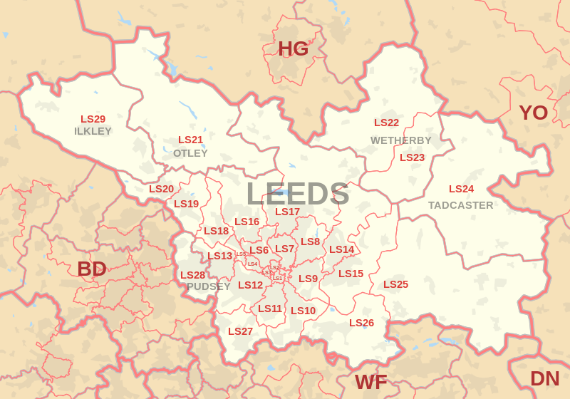
This Post covers
Coverage Area of Postcode LS20 to LS29
|
|
| Postcode |
Coverage Area |
Local Authority Area |
| LS20 |
Guiseley, Hawksworth |
Leeds |
| LS21 |
Arthington, Otley, Pool, Fewston, Blubberhouses |
Leeds, Harrogate |
| LS22 |
Collingham, Linton, Wetherby |
Leeds, Harrogate |
| LS23 |
Boston Spa, Bramham, Clifford, Thorp Arch, Walton |
Leeds |
| LS24 |
Saxton, Stutton, Ulleskelf, Church Fenton, Oxton, Tadcaster, Toulston |
Selby |
| LS25 |
Aberford, Ferry Fryston, Garforth, Hillam, Kippax, Ledsham, Micklefield, Monk Fryston, Sherburn-in-Elmet, South Milford |
Leeds |
| LS26 |
Great Preston, Methley, Mickletown, Oulton, Rothwell, Swillington, Woodlesford |
Leeds |
| LS27 |
Churwell, Gildersome, Morley |
Leeds |
| LS28 |
Bagley, Calverley, Farsley, Pudsey, Stanningley |
Leeds |
| LS29 |
Addingham, Ben Rhydding, Burley in Wharfedale, Ilkley, Menston |
Bradford, Harrogate |
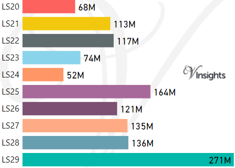
- M represents Million Pounds
- Total value includes Property Type Other apart from Detached, Semi-Detached, Terraced, Flat/Masionette
Schools for Postcode Area LS
- Leeds LS Postcode Area - LS1, LS2, LS3, LS4, LS5, LS6, LS7, LS8, LS9 School Details
- Leeds LS Postcode Area - LS10, LS11, LS12, LS13, LS14, LS15, LS16, LS17, LS18, LS19 School Details
- Leeds LS Postcode Area - LS20, LS21, LS22, LS23, LS24, LS25, LS26, LS27, LS28, LS29 School Details
Property Posts for Postcode Area LS
d78f2ff3-7cfc-4b38-b6f4-9656d3c81b54|0|.0|27604f05-86ad-47ef-9e05-950bb762570c
Tags :
23. April 2018 20:02
/
VInsights Team
/
/
Comments (0)
Please click here for the updated version of this post
This Post covers
Coverage Area of Postcode LS10 to LS19
|
|
| Postcode |
Coverage Area |
Local Authority Area |
| LS10 |
Belle Isle, Hunslet, Leeds city centre, Middleton, Stourton |
Leeds |
| LS11 |
Leeds city centre, Beeston, Beeston Hill, Cottingley, Holbeck |
Leeds |
| LS12 |
Armley, Farnley, New Farnley, Wortley |
Leeds |
| LS13 |
Bramley, Gamble Hill, Moorside, Rodley, Swinnow |
Leeds |
| LS14 |
Killingbeck, Seacroft, Scarcroft, Swarcliffe, Thorner, Whinmoor |
Leeds |
| LS15 |
Austhorpe, Barwick-in-Elmet, Colton, Cross Gates, Halton,
Halton Moor, Manston, Pendas Fields, Scholes,
Temple Newsam, Whitkirk |
Leeds |
| LS16 |
Adel, Bramhope, Cookridge, Eccup, Far Headingley,
Holt Park, Ireland Wood, Lawnswood, Moor Grange,
Tinshill, Weetwood, West Park |
Leeds |
| LS17 |
Alwoodley, Bardsey, East Keswick, Eccup,
Harewood, Moortown, Shadwell, Weardley, Wike |
Leeds, Harrogate |
| LS18 |
Horsforth |
Leeds |
| LS19 |
Carlton, Rawdon, Yeadon |
Leeds |
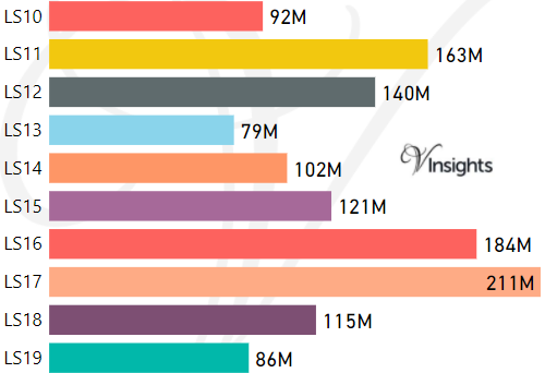
- M represents Million Pounds
- Total value includes Property Type Other apart from Detached, Semi-Detached, Terraced, Flat/Masionette
Schools for Postcode Area LS
- Leeds LS Postcode Area - LS1, LS2, LS3, LS4, LS5, LS6, LS7, LS8, LS9 School Details
- Leeds LS Postcode Area - LS10, LS11, LS12, LS13, LS14, LS15, LS16, LS17, LS18, LS19 School Details
- Leeds LS Postcode Area - LS20, LS21, LS22, LS23, LS24, LS25, LS26, LS27, LS28, LS29 School Details
Property Posts for Postcode Area LS
ea5ad8d6-782e-43d7-9b03-7cc2c9ec1fd1|0|.0|27604f05-86ad-47ef-9e05-950bb762570c
Tags :