VInsights
Amenities
Crime
Census
Property
Schools
Contact
Search
VInsights - Navigation
L17 8XY St Michael's - Nearest Schools Within 5 Kms of the Postcode
*Circle represents 5 km raidus around the Postcode L17 8XY
View Large Map
This Post covers
L17 8XY : Street, Ward, Borough, County Details
L17 8XY : School Distribution By Distance
L17 8XY : All Schools within 2 Kms
L17 8XY : All Schools within 2 - 3 Kms
L17 8XY : All Schools within 3 - 4 Kms
L17 8XY : All Schools within 4 - 5 Kms
Amenities Available in the Neighbourhood
Hospitality Premises in the Neighbourhood
Businesses in the Neighbourhood
Property Details in the Neighbourhood
Crime Details in the Neighbourhood
Demographic Composition of the Neighbourhood
L17 8XY : Street, Ward, Borough, County Details
*Is Active
Street
Ward
Borough
County
Yes
Livingston Drive
St Michael's
Liverpool
Merseyside
*Is Active = It denotes whether the Postcode is Presently Active or Not
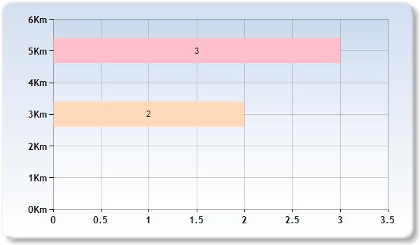
L17 8XY : School Distribution By Distance
Km represents Kilometer for eg 2 Km represent Schools within 1 -2 Kilometers
The above graph represents distribution of Schools from Postcode L17 8XY by distance
L17 8XY : All Schools within 2 Kms
Nearest 15 Schools
Rest of the Schools (within 2 kms)
Loading……..
School
School Postcode
*Distance
Phase
Gender
*F.S.
Ofsted
Area
Auckland College
L17 4LE
0.29 km
Not applicable
Mixed
N
Rating
Liverpool
St Michael-in-the-Hamlet Community Primary School
L17 7BA
0.37 km
Primary
Mixed
N
Rating
Liverpool
St Charles' Catholic Primary School
L17 7JA
0.4 km
Primary
Mixed
Y
Rating
Liverpool
Bellerive FCJ Catholic College
L17 3AA
0.61 km
Secondary
Girls
Y
Rating
Liverpool
King's Leadership Academy, Liverpool
L8 9SJ
0.98 km
Secondary
Mixed
N
Rating
Liverpool
ASPIRE Centre, Kings Leadership Academy Liverpool
L8 9SJ
0.98 km
Not applicable
Mixed
N
Rating
Liverpool
St Hilda's Church of England High School
L17 3AL
1.06 km
Secondary
Mixed
Y
Rating
Liverpool
Belvedere Preparatory School
L8 3TF
1.11 km
Not applicable
Mixed
N
Rating
Liverpool
The Belvedere Academy
L8 3TF
1.11 km
Secondary
Girls
N
Rating
Liverpool
St Finbar's Catholic Primary School
L8 9RY
1.14 km
Primary
Mixed
Y
Rating
Liverpool
Matthew Arnold Primary School
L8 9UB
1.17 km
Primary
Mixed
N
Rating
Liverpool
Liverpool College
L18 8BG
1.3 km
All through
Mixed
Y
Rating
Liverpool
Sudley Infant School
L17 0AE
1.36 km
Primary
Mixed
N
Rating
Liverpool
St Silas Church of England Primary School
L8 3TP
1.44 km
Primary
Mixed
Y
Rating
Liverpool
Sudley Junior School
L17 6BH
1.51 km
Primary
Mixed
N
Rating
Liverpool
*Distance = It refers to the straight line distance between Postcode L17 8XY and the School Postcode
*F.S. = Faith School, N= No, Y= Yes
L17 8XY : All Schools within 2 - 3 Kms
Nearest 15 Schools
Rest of the Schools (within 2 - 3 kms)
Loading……..
School
School Postcode
Distance
Phase
Gender
*F.S.
Ofsted
Area
Lawrence Community Primary School
L15 0EE
2.12 km
Primary
Mixed
N
Rating
Liverpool
Princes School
L8 1YQ
2.16 km
Not applicable
Mixed
N
Rating
Liverpool
Archbishop Blanch School
L7 6HQ
2.18 km
Secondary
Girls
Y
Rating
Liverpool
Windsor Community Primary School
L8 8JE
2.18 km
Primary
Mixed
N
Rating
Liverpool
St Hugh's Catholic Primary School
L7 6HE
2.2 km
Primary
Mixed
Y
Rating
Liverpool
Chatham Place Nursery School
L7 6HD
2.22 km
Nursery
Mixed
N
Rating
Liverpool
St Patrick's Catholic Primary School
L8 5UX
2.27 km
Primary
Mixed
Y
Rating
Liverpool
Smithdown Primary School
L7 6LJ
2.35 km
Primary
Mixed
N
Rating
Liverpool
The Blue Coat School
L15 9EE
2.46 km
Secondary
Mixed
N
Rating
Liverpool
Royal School for the Blind (Liverpool)
L15 6TQ
2.62 km
Not applicable
Mixed
N
Rating
Liverpool
Assess Education
L15 4LP
2.63 km
Not applicable
Mixed
N
Rating
Liverpool
Abercromby Nursery School
L8 7QA
2.67 km
Nursery
Mixed
N
Rating
Liverpool
Christian Fellowship School
L7 3HL
2.67 km
Not applicable
Mixed
Y
Rating
Liverpool
Wavertree Church of England School
L15 8HJ
2.69 km
Primary
Mixed
Y
Rating
Liverpool
Booker Avenue Junior School
L18 9SB
2.73 km
Primary
Mixed
N
Rating
Liverpool
*Distance = It refers to the straight line distance between Postcode L17 8XY and the School Postcode
*F.S. = Faith School, N= No, Y= Yes
L17 8XY : All Schools within 3 - 4 Kms
Nearest 15 Schools
Rest of the Schools (within 3 - 4 kms)
Loading……..
School
School Postcode
Distance
Phase
Gender
*F.S.
Ofsted
Area
Our Lady's Bishop Eton Catholic Primary School
L18 2EP
3.11 km
Primary
Mixed
Y
Rating
Liverpool
Gilmour (Southbank) Infant School
L19 9AR
3.13 km
Primary
Mixed
N
Rating
Liverpool
Cities in Schools at Unit 302
L1 0BG
3.16 km
Not applicable
Not applicable
N
Rating
Liverpool
King David High School
L15 6UZ
3.27 km
Secondary
Mixed
Y
Rating
Liverpool
King David Primary School
L15 6WU
3.31 km
Primary
Mixed
Y
Rating
Liverpool
Gilmour Junior School
L19 1RD
3.32 km
Primary
Mixed
N
Rating
Liverpool
University of Liverpool
L69 7ZX
3.34 km
Not applicable
Mixed
N
Rating
Liverpool
Kensington Primary School
L7 2QG
3.35 km
Primary
Mixed
N
Rating
Liverpool
Liverpool John Moores University
L3 5UX
3.36 km
Not applicable
Mixed
N
Rating
Liverpool
St Nicholas's Catholic Primary School
L3 5XF
3.41 km
Primary
Mixed
Y
Rating
Liverpool
Pleasant Street Primary School
L3 5TS
3.42 km
Primary
Mixed
N
Rating
Liverpool
The City of Liverpool College
L3 5TP
3.42 km
16 plus
Mixed
N
Rating
Liverpool
Carleton House Preparatory School
L18 3EE
3.42 km
Not applicable
Mixed
Y
Rating
Liverpool
St Vincent de Paul Catholic Primary School
L1 5BY
3.43 km
Primary
Mixed
Y
Rating
Liverpool
St Sebastian's Catholic Primary School and Nursery
L7 0LH
3.5 km
Primary
Mixed
Y
Rating
Liverpool
*Distance = It refers to the straight line distance between Postcode L17 8XY and the School Postcode
*F.S. = Faith School, N= No, Y= Yes
L17 8XY : All Schools within 4 - 5 Kms
Nearest 15 Schools
Rest of the Schools (within 4 - 5 kms)
Loading……..
School
School Postcode
*Distance
Phase
Gender
*F.S.
Ofsted
Area
Employability Solutions Independent School
L19 2LX
4.01 km
Not applicable
Mixed
N
Rating
Liverpool
Springwood Heath Primary School
L19 4TL
4.02 km
Primary
Mixed
N
Rating
Liverpool
Rudston Primary School
L16 4PQ
4.08 km
Primary
Mixed
N
Rating
Liverpool
New Park Primary School
L6 9EU
4.09 km
Primary
Mixed
N
Rating
Liverpool
St Oswalds Catholic Primary School
L13 5TE
4.12 km
Primary
Mixed
Y
Rating
Liverpool
Abbot's Lea School
L25 6EE
4.15 km
Not applicable
Mixed
N
Rating
Liverpool
St Cuthbert's Catholic Primary and Nursery School
L13 3BB
4.15 km
Primary
Mixed
Y
Rating
Liverpool
Grove Street Primary School
CH62 5BA
4.23 km
Primary
Mixed
N
Rating
Wirral
The Academy of St Francis of Assisi
L6 7UR
4.25 km
Secondary
Mixed
Y
Rating
Liverpool
St Francis Xavier's College
L25 6EG
4.25 km
Secondary
Boys
Y
Rating
Liverpool
Garston Church of England Primary School
L19 5NS
4.3 km
Primary
Mixed
Y
Rating
Liverpool
The Academy of St Nicholas
L19 5NY
4.31 km
Secondary
Mixed
Y
Rating
Liverpool
St Michael's Catholic Primary School
L6 9DU
4.33 km
Primary
Mixed
Y
Rating
Liverpool
Woolton High School
L25 6JA
4.37 km
Not applicable
Mixed
N
Rating
Liverpool
St Anne's (Stanley) Junior Mixed and Infant School
L13 3BT
4.38 km
Primary
Mixed
Y
Rating
Liverpool
*Distance = It refers to the straight line distance between Postcode L17 8XY and the School Postcode
*F.S. = Faith School, N= No, Y= Yes
Amenities Available in the Neighbourhood
Childcare, Caring Premises
Supermarkets, Hypermarkets
Retailers
Hospitals
Rail Stations
Hospitality Premises in the Neighbourhood
Pubs, Bars, Nightclubs
Restaurants, Cafes, Canteens
Takeaways, Sandwich Shops
Hotels, Bed & Breakfast, Guest Houses
Catering Premises
Mobile Caterers
Caterers in School, College, University
Businesses in the Neighbourhood
Distributors, Transporters
Farmers, Growers
Importers, Exporters
Manufacturers
Property Details in the Neighbourhood
Postcode Level Property Analysis
House Prices in the Neighbourhood of the Postcode
Postcode Sector Level Property Details
Postcode District Level Property Details
Postcode Area Level Property Details
St Michael's Multiyear Trend Analysis of Property Market
Liverpool Multiyear Trend Analysis of Property Market
Merseyside Multiyear Trend Analysis of Property Market
North West Multiyear Trend Analysis of Property Market
England Multiyear Trend Analysis of Property Market
Crime Details in the Neighbourhood
Crimes in Year 2019
Crimes in Year 2018
Demographic Composition of the Neighbourhood
St Michael's Demographics Compsition
Liverpool Demographics Compsition
North West Demographics Compsition
Contains public sector information licensed under the Open Government Licence v3.0