VInsights
Amenities
Crime
Census
Property
Schools
Contact
Search
VInsights - Navigation
BB2 4BD Ewood - Nearest Schools Within 5 Kms of the Postcode
*Circle represents 5 km raidus around the Postcode BB2 4BD
View Large Map
This Post covers
BB2 4BD : Street, Ward, Borough, County Details
BB2 4BD : School Distribution By Distance
BB2 4BD : All Schools within 2 Kms
BB2 4BD : All Schools within 2 - 3 Kms
BB2 4BD : All Schools within 3 - 4 Kms
BB2 4BD : All Schools within 4 - 5 Kms
BB2 4BD : Related Posts
BB2 4BD : Street, Ward, Borough, County Details
*Is Active
Street
Ward
Borough
County
Yes
Hamilton Street
Ewood
Blackburn with Darwen
Lancashire
*Is Active = It denotes whether the Postcode is Presently Active or Not
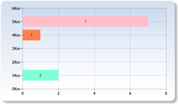
BB2 4BD : School Distribution By Distance
Km represents Kilometer for eg 2 Km represent Schools within 1 -2 Kilometers
The above graph represents distribution of Schools from Postcode BB2 4BD by distance
BB2 4BD : All Schools within 2 Kms
Nearest 15 Schools
Rest of the Schools (within 2 kms)
Loading……..
School
School Postcode
*Distance
Phase
Gender
*F.S.
Ofsted
Area
St Luke and St Philips Church of England Primary School
BB2 2LZ
0.45 km
Primary
Mixed
Y
Rating
Blackburn with Darwen
St Aidan's Primary School - A Church of England Academy
BB2 4EW
0.6 km
Primary
Mixed
Y
Rating
Blackburn with Darwen
Longshaw Community Junior School
BB2 3NX
0.62 km
Primary
Mixed
N
Rating
Blackburn with Darwen
St Wilfrid's Church of England Academy
BB2 2JR
0.72 km
Secondary
Mixed
Y
Rating
Blackburn with Darwen
Griffin Park Primary School
BB2 2PN
0.89 km
Primary
Mixed
N
Rating
Blackburn with Darwen
Markazul Uloom
BB2 3NY
0.9 km
Not applicable
Mixed
Y
Rating
Blackburn with Darwen
Longshaw Nursery School
BB2 3NF
0.98 km
Nursery
Mixed
N
Rating
Blackburn with Darwen
Longshaw Infant School
BB2 3NF
0.98 km
Primary
Mixed
N
Rating
Blackburn with Darwen
St Peter's Roman Catholic Primary School, Blackburn
BB2 2RY
1.01 km
Primary
Mixed
Y
Rating
Blackburn with Darwen
St Barnabas and St Paul's Church of England Voluntary Aided Primary School
BB2 1SN
1.14 km
Primary
Mixed
Y
Rating
Blackburn with Darwen
St Mary's and St Joseph's Roman Catholic Primary School Blackburn
BB2 3HP
1.28 km
Primary
Mixed
Y
Rating
Blackburn with Darwen
Blackburn the Redeemer CofE Primary
BB2 4JJ
1.28 km
Primary
Mixed
Y
Rating
Blackburn with Darwen
Meadowhead Infant School
BB2 4TT
1.3 km
Primary
Mixed
N
Rating
Blackburn with Darwen
Ashworth Nursery School
BB2 1QU
1.31 km
Nursery
Mixed
N
Rating
Blackburn with Darwen
St Anne's Roman Catholic Primary School Blackburn
BB2 1LQ
1.31 km
Primary
Mixed
Y
Rating
Blackburn with Darwen
*Distance = It refers to the straight line distance between Postcode BB2 4BD and the School Postcode
*F.S. = Faith School, N= No, Y= Yes
BB2 4BD : All Schools within 2 - 3 Kms
Nearest 15 Schools
Rest of the Schools (within 2 - 3 kms)
Loading……..
School
School Postcode
Distance
Phase
Gender
*F.S.
Ofsted
Area
Sacred Heart Roman Catholic Primary School Blackburn
BB2 6HQ
2.01 km
Primary
Mixed
Y
Rating
Blackburn with Darwen
St Alban's Roman Catholic Primary School Blackburn
BB1 5BN
2.05 km
Primary
Mixed
Y
Rating
Blackburn with Darwen
St Thomas's Centre
BB1 1NA
2.24 km
Not applicable
Mixed
N
Rating
Blackburn with Darwen
St James' Church of England Primary School
BB3 0QP
2.24 km
Primary
Mixed
Y
Rating
Blackburn with Darwen
Blackburn St Thomas' Church of England Primary School
BB1 1NE
2.27 km
Primary
Mixed
Y
Rating
Blackburn with Darwen
The Olive School Blackburn
BB2 6QQ
2.36 km
Primary
Mixed
Y
Rating
Blackburn with Darwen
Livesey Saint Francis' Church of England School
BB2 5NX
2.36 km
Primary
Mixed
Y
Rating
Blackburn with Darwen
Newfield School
BB1 2PW
2.39 km
Not applicable
Mixed
N
Rating
Blackburn with Darwen
Darwen Vale High School
BB3 0AL
2.4 km
Secondary
Mixed
N
Rating
Blackburn with Darwen
St James' Church of England Primary School Blackburn
BB1 8EG
2.43 km
Primary
Mixed
Y
Rating
Blackburn with Darwen
Lower Darwen Primary School
BB3 0RB
2.5 km
Primary
Mixed
N
Rating
Blackburn with Darwen
Our Lady and St John Catholic College
BB1 1PY
2.56 km
Secondary
Mixed
Y
Rating
Blackburn with Darwen
Tauheedul Islam Boys' High School
BB1 2HT
2.56 km
Secondary
Boys
Y
Rating
Blackburn with Darwen
St Mary's College
BB1 8DX
2.68 km
16 plus
Mixed
Y
Rating
Blackburn with Darwen
Jamiatul-Ilm Wal-Huda UK School
BB1 5JT
2.71 km
Not applicable
Boys
N
Rating
Blackburn with Darwen
*Distance = It refers to the straight line distance between Postcode BB2 4BD and the School Postcode
*F.S. = Faith School, N= No, Y= Yes
BB2 4BD : All Schools within 3 - 4 Kms
Nearest 15 Schools
Rest of the Schools (within 3 - 4 kms)
Loading……..
School
School Postcode
Distance
Phase
Gender
*F.S.
Ofsted
Area
Shadsworth Junior School
BB1 2ET
3.02 km
Primary
Mixed
N
Rating
Blackburn with Darwen
Cedars Primary School
BB1 8HQ
3.03 km
Primary
Mixed
N
Rating
Blackburn with Darwen
St Edward's Roman Catholic Primary School Blackburn
BB3 0AA
3.04 km
Primary
Mixed
Y
Rating
Blackburn with Darwen
Islamiyah School
BB1 5NQ
3.08 km
Not applicable
Girls
Y
Rating
Blackburn with Darwen
St Stephen's Church of England Primary School
BB1 5PE
3.1 km
Primary
Mixed
Y
Rating
Blackburn with Darwen
St Paul's Roman Catholic Primary School, Feniscowles, Blackburn
BB2 5EP
3.16 km
Primary
Mixed
Y
Rating
Blackburn with Darwen
Shadsworth Infant School
BB1 2EL
3.24 km
Primary
Mixed
N
Rating
Blackburn with Darwen
Feniscowles Primary School
BB2 5EG
3.29 km
Primary
Mixed
N
Rating
Blackburn with Darwen
St Cuthbert's Church of England Primary School
BB3 0HY
3.31 km
Primary
Mixed
Y
Rating
Blackburn with Darwen
Westholme School
BB2 6QU
3.31 km
Not applicable
Mixed
Y
Rating
Blackburn with Darwen
Lammack Primary School
BB1 8LH
3.4 km
Primary
Mixed
N
Rating
Blackburn with Darwen
Pleckgate High School
BB1 8QA
3.5 km
Secondary
Mixed
N
Rating
Blackburn with Darwen
Intack Primary School
BB1 3HY
3.5 km
Primary
Mixed
N
Rating
Blackburn with Darwen
St Stephen's Tockholes CofE Primary School
BB3 0LX
3.7 km
Primary
Mixed
Y
Rating
Blackburn with Darwen
St Gabriel's Church of England Primary School
BB1 8QN
3.81 km
Primary
Mixed
Y
Rating
Blackburn with Darwen
*Distance = It refers to the straight line distance between Postcode BB2 4BD and the School Postcode
*F.S. = Faith School, N= No, Y= Yes
BB2 4BD : All Schools within 4 - 5 Kms
Loading……..
School
School Postcode
*Distance
Phase
Gender
*F.S.
Ofsted
Area
Roe Lee Park Primary School
BB1 9RP
4.1 km
Primary
Mixed
N
Rating
Blackburn with Darwen
Darwen St James CofE Primary Academy
BB3 0EY
4.29 km
Primary
Mixed
Y
Rating
Blackburn with Darwen
Darwen Aldridge Enterprise Studio
BB3 1AF
4.64 km
Secondary
Mixed
N
Rating
Blackburn with Darwen
Belthorn Academy Primary School
BB1 2NY
4.65 km
Primary
Mixed
N
Rating
Lancashire
Holy Trinity VC School
BB3 2RW
4.85 km
Primary
Mixed
Y
Rating
Blackburn with Darwen
Mellor St Mary Church of England Primary School
BB2 7JT
4.91 km
Primary
Mixed
Y
Rating
Lancashire
Darwen Aldridge Community Academy
BB3 3HD
4.97 km
Secondary
Mixed
N
Rating
Blackburn with Darwen
Sudell Primary School
BB3 3EB
4.98 km
Primary
Mixed
N
Rating
Blackburn with Darwen
*Distance = It refers to the straight line distance between Postcode BB2 4BD and the School Postcode
*F.S. = Faith School, N= No, Y= Yes
BB2 4BD : Related Posts
Nearest Rail Stations within 5 Kilometers of the Postcode, BB2 4BD
Nearest Hospitals within 5 Kilometers of the Postcode, BB2 4BD
BB2 4BD Hamilton Street, Crime Statistics For Year 2019
BB2 4BD Hamilton Street, Crime Statistics For Year 2018
BB2 4BD Hamilton Street, Property Market Analysis
House Prices in the Neighbourhood of Hamilton Street, BB2 4BD
BB2 4 Sector Level Multiyear Trend Analysis of Property Market
BB2 District Level Multiyear Trend Analysis of Property Market
Ewood Multiyear Trend Analysis of Property Market
Blackburn with Darwen Multiyear Trend Analysis of Property Market
Lancashire Multiyear Trend Analysis of Property Market
North West Multiyear Trend Analysis of Property Market
England Multiyear Trend Analysis of Property Market
Contains public sector information licensed under the Open Government Licence v3.0