Please click here for the updated version of this post
This Post covers
- Coverage Area of Postcode SE10 to SE19
- Total Sales By Postcode SE10 to SE19
- Average & Median Sales Price By Postcode SE10 to SE19
- Total Number of Sales By Postcode SE10 to SE19
- Multi Year Property Trend Analysis By Postcode SE10 to SE19
- Schools for Postcode Area SE
- Posts for Postcode Area SE
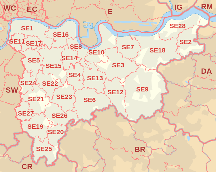
Coverage Area of Postcode SE10 to SE19
 |
| Postcode |
Coverage Area |
Local Authority Area |
| SE10 |
Greenwich, Maze Hill, Greenwich Peninsula |
Greenwich, Lewisham |
| SE11 |
Kennington, Lambeth (part), Vauxhall (part) |
Lambeth, Southwark |
| SE12 |
Lee, Grove Park, Chinbrook, Hither Green (part), Eltham (part), Horn Park, Blackheath (part) |
Greenwich, Lewisham |
| SE13 |
Lewisham, Hither Green, Ladywell |
Greenwich, Lewisham |
| SE14 |
New Cross |
Lewisham,Southwark |
| SE15 |
Peckham, Nunhead, South Bermondsey (part), Old Kent Road (part) |
Lewisham, Southwark |
| SE16 |
Rotherhithe, Surrey Quays |
Southwark,Lewisham |
| SE17 |
Walworth, Kennington (part), Newington |
Southwark |
| SE18 |
Woolwich, Royal Arsenal, Plumstead, Shooter's Hill |
Bexley, Greenwich |
| SE19 |
Upper Norwood, Crystal Palace |
Bromley, Croydon, Lambeth, Lewisham, Southwark |
Total Sales By Postcode in 2016
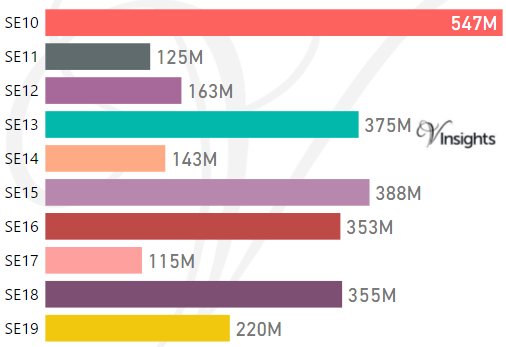
*M represents millions
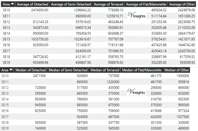
Average & Median Sales Price By Postcode in 2016
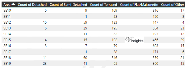
Total Number Of Sales By Postcode in 2016
Multi Year Property Trend Analysis By Postcode
Schools for Postcode Area SE
- London SE Postcode Area - SE1, SE2, SE3, SE4, SE5, SE6, SE7, SE8, SE9 School Details
- London SE Postcode Area - SE10, SE11, SE12, SE13, SE14, SE15, SE16, SE17, SE18, SE19 School Details
- London SE Postcode Area - SE20, SE21, SE22, SE23, SE24, SE25, SE26, SE27, SE28 School Details
Posts for Postcode Area SE
All SE Postcode Area Posts

Reference
SE Postcode Area As Per Wikipedia
bba2ef6e-1364-43fa-944f-a41f3bf0d274|0|.0|27604f05-86ad-47ef-9e05-950bb762570c