Please click here for the updated version of this post
This Post covers
- Coverage Area of Postcode WN1 to WN8
- Total Sales By Postcode WN1 to WN8
- Average & Median Sales Price By Postcode WN1 to WN8
- Total Number of Sales By Postcode WN1 to WN8
- Schools for Postcode Area WN
- Property Posts for Postcode Area WN
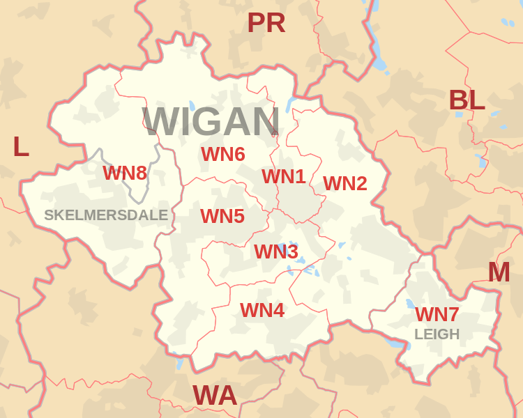
Coverage Area of Postcode WN1 to WN8
 |
| Postcode |
Coverage Area |
Local Authority Area |
| WN1 |
Haigh, Ince, Swinley, Wigan |
Wigan |
| WN2 |
Abram, Aspull, Bamfurlong, Bickershaw, Haigh, Hindley, Hindley Green, Ince, Platt Bridge |
Wigan |
| WN3 |
Goose Green, Ince, Winstanley, Worsley Mesnes, Hawkley Hall |
Wigan |
| WN4 |
Ashton-in-Makerfield, Garswood |
Wigan, St Helens |
| WN5 |
Billinge, Newtown, Higher End, Orrell, Pemberton,
Winstanley, Worsley Hall, Marsh Green. |
Wigan, St Helens |
| WN6 |
Appley Bridge, Shevington, Standish, Standish Lower Ground, Wrightington |
Wigan, West Lancashire |
| WN7 |
Hope Carr, Landside, Leigh, Low Common, Bedford, Westleigh, Pennington, Higher Folds |
Wigan |
| WN8 |
Chapel House, Dalton, Holland Moor, Newburgh, Parbold,
Roby Mill, Skelmersdale, Southway, Upholland |
West Lancashire |
Total Sales By Postcode
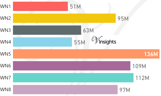
*M represent Million Pounds
Average & Median Sales Price By Postcode
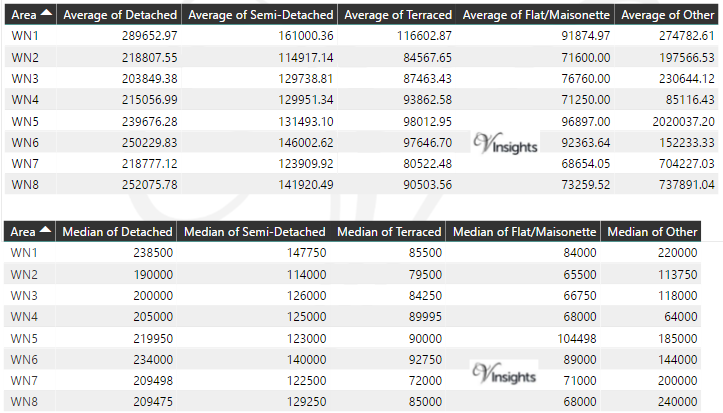
*Average and Median Sales Price are in Pounds
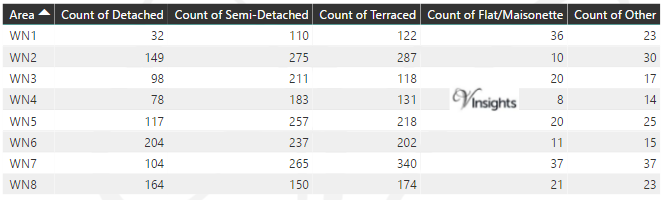
Total Number Of Sales By Postcode
Schools for Postcode Area WN
Property Posts for Postcode Area WN
All North West England Postcode Area Posts

Reference
WN Postcode Area As Per Wikipedia
412e0927-c7c3-4246-8b02-2d7b566d86cc|0|.0|27604f05-86ad-47ef-9e05-950bb762570c