Please click here for the updated version of this post
This Post covers
- Coverage Area of Postcode W10 to W14
- Total Sales By Postcode W10 to W14
- Average & Median Sales Price By Postcode W10 to W14
- Total Number of Sales By Postcode W10 to W14
- Multi Year Property Trend Analysis By Postcode W10 to W14
- Schools for Postcode Area W
- Posts for Postcode Area W
Coverage Area of Postcode W10 to W14
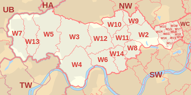 |
| Postcode |
Coverage Area |
Local Authority Area |
| W10 |
North Kensington, Kensal Town, Ladbroke Grove (north), Queen's Park (part) |
Kensington and Chelsea, Westminster, Hammersmith and Fulham, Brent |
| W11 |
Notting Hill, Ladbroke Grove (south), Holland Park (part) |
Kensington and Chelsea, Westminster, Hammersmith and Fulham |
| W12 |
Shepherds Bush, White City, Wormwood Scrubs, East Acton (east) |
Hammersmith and Fulham |
| W13 |
West Ealing, Northfields (north and west) |
Ealing |
| W14 |
West Kensington, Kensington Olympia, Holland Park |
Hammersmith and Fulham, Kensington and Chelsea |
Total Sales By Postcode in 2016
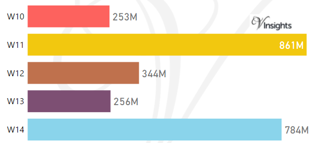
The Total Sales by the Postcodes are:
- W10 £253 millions, W11 £861 millions , W12 £344 millions
- W13 £256 millions, W14 £784 millions
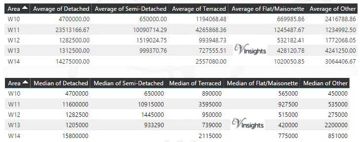
Average & Median Sales Price By Postcode in 2016
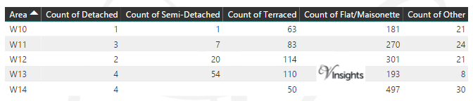
Total Number Of Sales By Postcode in 2016
Multi Year Property Trend Analysis By Postcode
Schools for Postcode Area W
- London W Postcode Area - W1B, W1C, W1D, W1F, W1G, W1H, W1J, W1K, W1S, W1T, W1U, W1W School Details
- London W Postcode Area - W2, W3, W4, W5, W6, W7, W8, W9 School Details
- London W Postcode Area - W10, W11, W12, W13, W14 School Details
Posts for Postcode Area W
All Postcode Area Posts

Reference
W Postcode Area As Per Wikipedia
88f6b1c0-a2bf-4449-9848-38871f9b49d7|0|.0|27604f05-86ad-47ef-9e05-950bb762570c