10. April 2018 14:31
/
VInsights Team
/
/
Comments (0)
Please click here for the updated version of this post
This Post covers
Coverage Area of Postcode TS1 to TS9
|
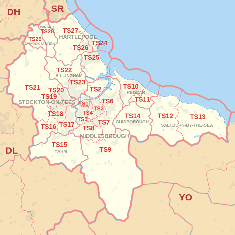
|
| Postcode |
Coverage Area |
Local Authority Area |
| TS1 |
Town Centre (Gresham, University, Abingdon) |
Middlesbrough |
| TS2 |
Middlehaven, Port Clarence |
Middlesbrough, Stockton-on-Tees |
| TS3 |
Brambles Farm, Thorntree, Park End, North Ormesby, Berwick Hills |
Middlesbrough |
| TS4 |
Grove Hill, Longlands |
Middlesbrough |
| TS5 |
Acklam, Linthorpe |
Middlesbrough |
| TS6 |
Eston, Grangetown, Normanby, Teesville, South Bank |
Redcar and Cleveland |
| TS7 |
Marton, Nunthorpe, Ormesby |
Middlesbrough, Redcar and Cleveland |
| TS8 |
Coulby Newham, Marton, Hemlington Stainton, Thornton & Maltby |
Middlesbrough, Stockton-on-Tees |
| TS9 |
Great Ayton, Stokesley |
Hambleton |
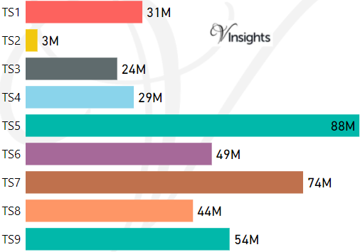
- M represents Million Pounds
- Total value includes Property Type Other apart from Detached, Semi-Detached, Terraced, Flat/Masionette
Schools for Postcode Area TS
- TS Postcode Area - TS1, TS2, TS3, TS4, TS5, TS6, TS7, TS8, TS9 School Details
- TS Postcode Area - TS10, TS11, TS12, TS13, TS14, TS15, TS16, TS17, TS18, TS19 School Details
- TS Postcode Area - TS20, TS21, TS22, TS23, TS24, TS25, TS26, TS27, TS28, TS29 School Details
Property Posts for Postcode Area TS
4f6a219d-1b33-4a70-a558-2df232b69ae0|0|.0|27604f05-86ad-47ef-9e05-950bb762570c
Tags :