Please click here for the updated version of this post
This Post covers
- Coverage Area of Postcode TD9 to TD15
- Total Sales By Postcode TD9 to TD15 in 2016
- Average & Median Sales Price By Postcode TD9 to TD15 in 2016
- Spread of Sales Price By Postcode TD9 to TD15 in 2016
- Total Number of Sales By Postcode TD9 to TD15 in 2016
- Schools for Postcode Area TD
- Property Posts for Postcode Area TD
Coverage Area of Postcode TD9 to TD15
|
|
| Postcode |
Coverage Area |
Local Authority Area |
| TD9 |
Hawick, Newcastleton, Bedrule, Bonchester Bridge, Chesters, Denholm, Kershopefoot, Newmill-on-Teviot, Roberton, Wilton Dean |
Scottish Borders Council, Carlisle |
| TD12 |
Coldstream, Cornhill-On-Tweed, Mindrum |
Scottish Borders Council, Northumberland |
| TD15 |
Holy Island |
Northumberland , Scottish Borders Council |
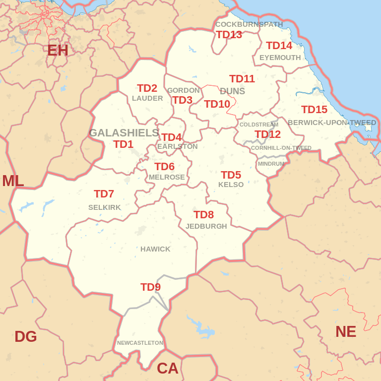
Total Sales By Postcode in 2016
*M represents Million Pounds
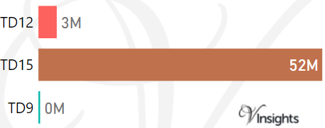
Average & Median Sales Price By Postcode in 2016
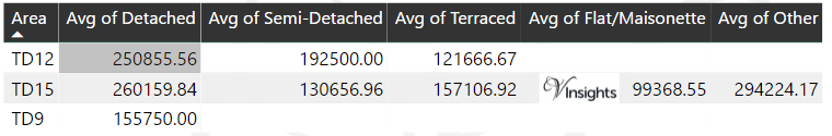
*Average and Median Sales Price are in Pounds
Spread of Sales Price By Postcode in 2016
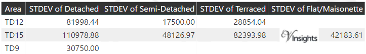
*STDEV is Standard Deviation
For example,
- Say the average detached property price for postcode XYZ is £300 K and ST. DEV. is 30 K.
- It means that most detached properties in postcode XYZ (about 68%) has price within one ST. Dev. i.e. the price range is £270K - £330K.
- All-most all detached property price (95%) in postcode XYZ lie between two ST. Dev. i.e. £240 K - £360 K
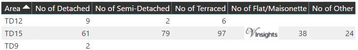
Total Number Of Sales By Postcode in 2016
Schools for Postcode Area TD
Property Posts for Postcode Area TD
North East England Postcode Area Posts

Reference
TD Postcode Area As Per Wikipedia
39085e03-29f3-4283-8911-8de00705cc10|0|.0|27604f05-86ad-47ef-9e05-950bb762570c