Please click here for the updated version of this post
This Post covers
- Coverage Area of Postcode SR1 to SR8
- Total Sales By Postcode SR1 to SR8 in 2016
- Average & Median Sales Price By Postcode SR1 to SR8 in 2016
- Spread of Sales Price By Postcode SR1 to SR8 in 2016
- Total Number of Sales By Postcode SR1 to SR8 in 2016
- Schools for Postcode Area SR
- Property Posts for Postcode Area SR
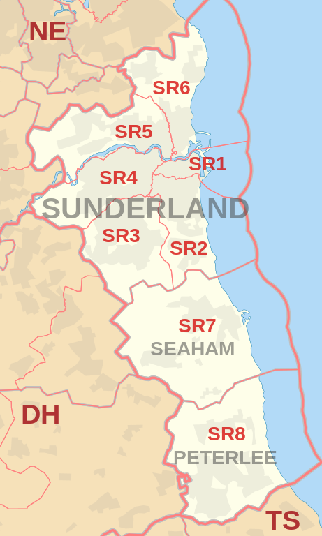
Coverage Area of Postcode SR1 to SR8
|
|
| Postcode |
Coverage Area |
Local Authority Area |
| SR1 |
Sunderland City Centre, East End, Hendon (north of Egerton Street) |
Sunderland |
| SR2 |
Ashbrooke, Ryhope, Grangetown, Hendon (south of Salisbury Street), Hillview, Thornhill |
Sunderland |
| SR3 |
Chapelgarth, Doxford Park, Farringdon, Elstob Farm, Essen Way, Gilley Law, Hall Farm, Herrington, Humbledon Hill, Mill Hill, Moorside, Plains Farm, Ryhope, Silksworth, Springwell Village, Thorney Close, Tunstall |
Sunderland |
| SR4 |
Ayres Quay, Barnes, Chester Road, Deptford, Ford Estate, Grindon, Hastings Hill, Hylton Lane Estate, High Barnes, Millfield, Tyne and Wear, Pallion, Ford Estate, Pennywell, South Hylton |
Sunderland |
| SR5 |
Carley Hill, Castletown, Downhill, Fulwell (west of Metro line), Hylton Castle, Hylton Red House, Marley Pots, Monkwearmouth (west of Metro line), Sheepfolds, Southwick, Town End Farm, Witherwack |
Sunderland |
| SR6 |
Cleadon, Fulwell (east of Metro line), Monkwearmouth (east of Metro line), North Haven, Roker, St Peter's Riverside, Seaburn, Seaburn Dene, South Bents, Whitburn |
Sunderland, South Tyneside |
| SR7 |
Cold Hesledon, Dalton-le-Dale, Dawdon, Deneside, Greenhill, Murton, Northlea, Parkside, Seaham, West Lea |
County Durham |
| SR8 |
Easington, Easington Colliery, Horden, Little Thorpe, Peterlee |
County Durham |
Total Sales By Postcode in 2016
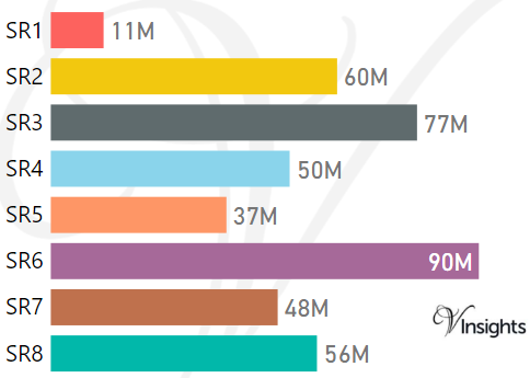
*M represents Million Pounds
Average & Median Sales Price By Postcode in 2016
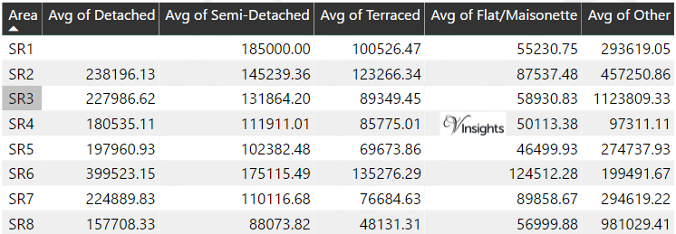
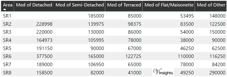
*Average and Median Sales Price are in Pounds
Spread of Sales Price By Postcode in 2016
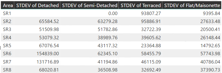
*STDEV is Standard Deviation
For example,
- Say the average detached property price for postcode XYZ is £300 K and ST. DEV. is 30 K.
- It means that most detached properties in postcode XYZ (about 68%) has price within one ST. Dev. i.e. the price range is £270K - £330K.
- All-most all detached property price (95%) in postcode XYZ lie between two ST. Dev. i.e. £240 K - £360 K
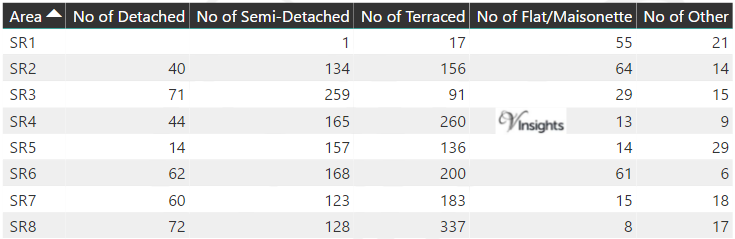
Total Number Of Sales By Postcode in 2016
Schools for Postcode Area SR
Property Posts for Postcode Area SR
North East England Postcode Area Posts

Reference
SR Postcode Area As Per Wikipedia
f52e541a-0fb8-47fe-9a3a-a4874499ccb5|0|.0|27604f05-86ad-47ef-9e05-950bb762570c