22. February 2018 16:56
/
VInsights Team
/
/
Comments (0)
Please click here for the updated version of this post
This Post covers
Coverage Area of Postcode SO14 to SO19
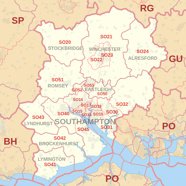 |
| Postcode |
Coverage Area |
Local Authority Area |
| SO14 |
City Centre, St. Mary's, Newtown, Nicholstown, Ocean Village, Chapel, Eastern Docks, Bevois Valley |
Southampton |
| SO15 |
Shirley, Freemantle, Banister Park, Millbrook, Redbridge |
Southampton |
| SO16 |
Bassett, Lordswood, Redbridge, Rownhams, Nursling, Chilworth |
Southampton, Test Valley |
| SO17 |
Highfield, Portswood, St Denys, Swaythling |
Southampton |
| SO18 |
Bitterne, Bitterne Park, Harefield, Townhill Park, Chartwell Green, Southampton Airport |
Southampton, Eastleigh |
| SO19 |
Sholing, Thornhill, Woolston, Weston |
Southampton |
- M represents Million Pounds
- Total value includes Property Type Other apart from Detached, Semi-Detached, Terraced, Flat/Masionette
Schools for Postcode Area SO
- SO Postcode Area - SO14, SO15, SO16,SO17, SO18, SO19 School Details
- SO Postcode Area - SO20, SO21, SO22, SO23, SO24, SO30, SO31, SO32 School Details
- SO Postcode Area - SO40, SO41, SO42, SO43, SO45, SO50, SO51, SO52, SO53 School Details
Property Posts for Postcode Area SO
All SO Postcodes Yearly & Trend Analysis Posts

Reference
SO Postcode Area As Per Wikipedia
16f160d6-08b5-44d1-b2ce-cfb85aa542ed|0|.0|27604f05-86ad-47ef-9e05-950bb762570c
Tags :