 This Post covers
- Coverage Area of Postcode SN10 to SN26
- School Details for Postcode Area SN10 to SN26
- Other Schools for Postcode Area SN
Coverage Area of Postcode SN10 to SN26
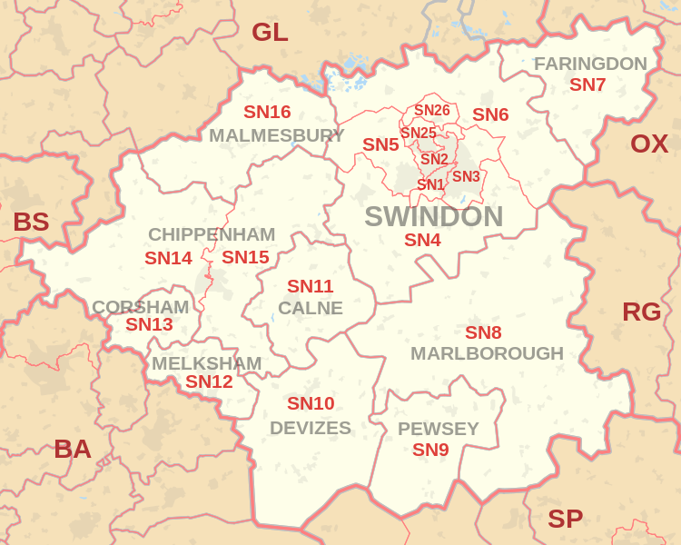 |
| Postcode |
Coverage Area |
Local Authority Area |
| SN10 |
Devizes, Market Lavington, Rowde |
Wiltshire |
| SN11 |
Calne, Heddington, Hilmarton |
Wiltshire |
| SN12 |
Melksham, Bowerhill, Seend, Broughton Gifford |
Wiltshire |
| SN13 |
Corsham, Box, Neston |
Wiltshire |
| SN14 |
Chippenham (west), Marshfield, Kington St Michael, Hullavington, Luckington, Grittleton, Yatton Keynell, Biddestone, Colerne |
Wiltshire, South Gloucestershire |
| SN15 |
Chippenham (east), Bromham, Sandy Lane, Lacock, Burleaze, Pewsham, Monkton Park, Foxham, Dauntsey, Seagry, Christian Malford, Bradenstoke, Sutton Benger, Lyneham, Draycot Cerne, Cleverton, Little Somerford, Langley Burrell, Great Somerford, Brinkworth |
Wiltshire |
| SN16 |
Sherston, Malmesbury, Crudwell, Minety |
Wiltshire |
| SN25 |
Haydon Wick, Priory Vale |
Swindon |
| SN26 |
Blunsdon |
Swindon |
where *F.S. = Faith School, *PERF = Performance, *D.F.E.=Department For Education
Schools in Postcode SN10
Schools in Postcode SN11
Schools in Postcode SN12
Schools in Postcode SN13
Schools in Postcode SN14
Schools in Postcode SN15
Schools in Postcode SN16
Schools in Postcode SN25
Schools in Postcode SN26
where *F.S. = Faith School, *PERF = Performance, *D.F.E.=Department For Education
Other Schools for Postcode Area SN
All SN Postcodes Yearly & Trend Analysis Posts

f996aa99-f844-43d0-b841-3e4c3097ad9f|0|.0|27604f05-86ad-47ef-9e05-950bb762570c