Please click here for the updated version of this post
This Post covers
- Coverage Area of Postcode SN1 to SN9
- Total Sales By Postcode SN1 to SN9
- Average & Median Sales Price By Postcode SN1 to SN9
- Total Number of Sales By Postcode SN1 to SN9
- Other Property Posts For Postcode Area SN
- Schools for Postcode Area SN
Coverage Area of Postcode SN1 to SN9
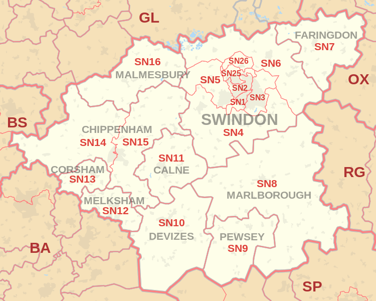 |
| Postcode |
Coverage Area |
Local Authority Area |
| SN1 |
Swindon Centre, south of the railway line |
Swindon |
| SN2 |
Swindon, north & Upper Stratton |
Swindon |
| SN3 |
Swindon, east & Stratton St Margaret, South Marston |
Swindon |
| SN4 |
Chiseldon, Royal Wootton Bassett, Wroughton |
Swindon, Wiltshire |
| SN5 |
West Swindon, Purton, Grange Park |
Swindon |
| SN6 |
Highworth, Cricklade, Shrivenham, Watchfield,
Ashton Keynes, Ashbury, Bishopstone, Castle Eaton, Hannington, Idstone, Marston Meysey, Leigh |
Swindon, Wiltshire, Vale Of White Horse |
| SN7 |
Faringdon, Stanford in the Vale, Uffington, Longcot, Fernham, Buckland, Great Coxwell, Little Coxwell, Littleworth, Shellingford, Buscot |
Vale Of White Horse |
| SN8 |
Marlborough, Ramsbury, Mildenhall, Aldbourne,
Axford, Burbage, Baydon, Great Bedwyn |
Wiltshire |
| SN9 |
Pewsey, Upavon, Enford |
Wiltshire |
Total Sales By Postcode
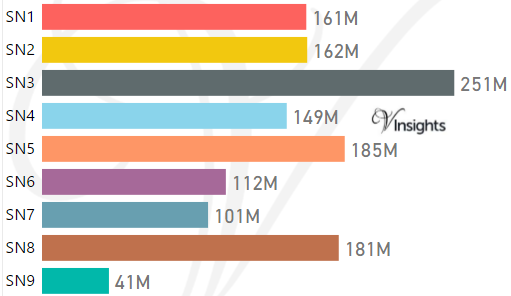
*M represent Million Pounds
Average & Median Sales Price By Postcode
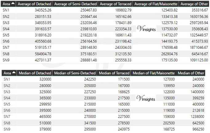
*Average and Median Sales Price are in Pounds
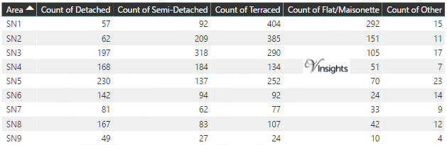
Total Number Of Sales By Postcode
Other Property Posts for Postcode Area SN
Schools for Postcode Area SN
- SN Postcode Area Property Market - SN1, SN2, SN3, SN4, SN5, SN6, SN7, SN8, SN9 School Details
- SN Postcode Area Property Market - SN10, SN11, SN12, SN13, SN14, SN15, SN16, SN25, SN26 School Details
All SN Postcodes Yearly & Trend Analysis Posts

Reference
SN Postcode Area As Per Wikipedia
4c176286-0c2d-4d08-aba3-beffed155e93|0|.0|27604f05-86ad-47ef-9e05-950bb762570c