Please click here for the updated version of this post
This Post covers
- Coverage Area of Postcode S1 to S9
- Total Sales By Postcode S1 to S9
- Average & Median Sales Price By Postcode S1 to S9
- Spread of Sales Price By Postcode S1 to S9
- Total Number of Sales By Postcode S1 to S9
- Property Posts for Postcode Area S
- Schools for Postcode Area S
Coverage Area of Postcode S1 to S9
|
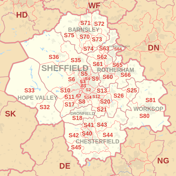
|
| Postcode |
Coverage Area |
Local Authority Area |
| S1 |
Sheffield City Centre |
Sheffield |
| S2 |
Arbourthorne, Heeley, Highfield, Manor, Norfolk Park, Wybourn, Park Hill |
Sheffield |
| S3 |
Broomhall, Burngreave, Neepsend, Netherthorpe |
Sheffield |
| S4 |
Grimesthorpe, Pitsmoor |
Sheffield |
| S5 |
Firth Park, Fir Vale, Longley, Shirecliffe, Shiregreen, Southey Green, Parson Cross |
Sheffield |
| S6 |
Bradfield, Dungworth, Hillsborough, Holdworth, Hollow Meadows, Loxley, Malin Bridge, Middlewood, Stannington, Storrs, Upperthorpe, Walkley, Wadsley Bridge, Wisewood, Wadsley, Fox Hill |
Sheffield |
| S7 |
Abbeydale, Carter Knowle, Nether Edge, Millhouses |
Sheffield |
| S8 |
Batemoor, Beauchief, Greenhill, Jordanthorpe, Lowedges, Meersbrook, Norton, Norton Lees, Woodseats |
Sheffield |
| S9 |
Attercliffe, Brightside, Darnall, Meadowhall, Tinsley, Wincobank |
Sheffield |
Total Sales By Postcode
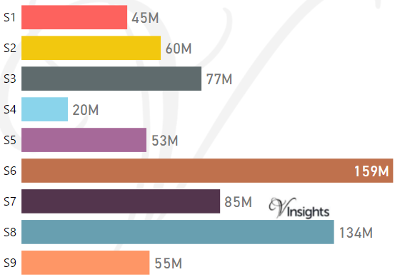
*M represents Million Pounds
Average & Median Sales Price By Postcode
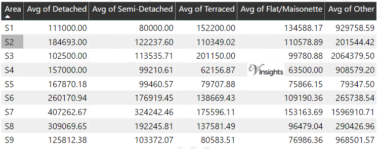
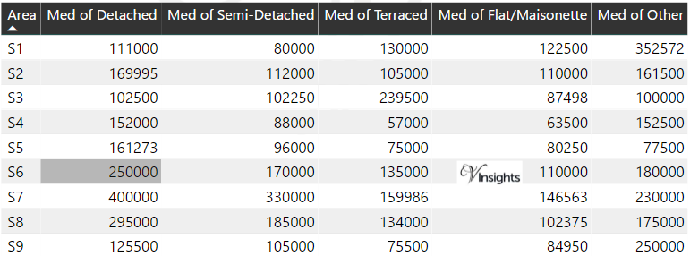
*Average and Median Sales Price are in Pounds
Spread of Sales Price By Postcode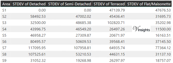
*STDEV is Standard Deviation
For example,
- Say the average detached property price for postcode XYZ is £300 K and ST. DEV. is 30 K.
- It means that most detached properties in postcode XYZ (about 68%) has price within one ST. Dev. i.e. the price range is £270K - £330K.
- All-most all detached property price (95%) in postcode XYZ lie between two ST. Dev. i.e. £240 K - £360 K
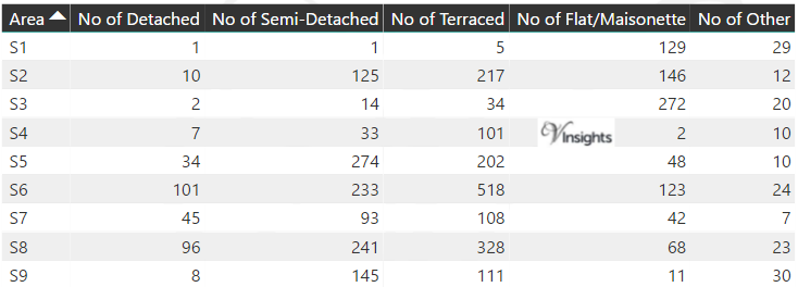
Total Number Of Sales By Postcode
Property Posts for Postcode Area S
Schools for Postcode Area S
- Sheffield S Postcode Area - S1, S2, S3, S4, S5, S6, S7, S8, S9 School Details
- S Postcode Area - S10, S11, S12, S13, S14, S17, S18 School Details
- S Postcode Area - S20, S21, S25, S26, S32, S33, S35, S36 School Details
- S Postcode Area - S40, S41, S42, S43, S44, S45 School Details
- S Postcode Area - S60, S61, S62, S63, S64, S65, S66 School Details
- S Postcode Area - S70, S71, S72, S73, S74, S75, S80, S81 School Details
All Yorkshire & Humber Postcode Area Posts

Reference
S Postcode Area As Per Wikipedia
f55de497-d2e2-46e8-9b92-34ca20c6dc0f|0|.0|27604f05-86ad-47ef-9e05-950bb762570c