24. April 2018 14:26
/
VInsights Team
/
/
Comments (0)
Please click here for the updated version of this post
This Post covers
Coverage Area of Postcode S70 to S81
|
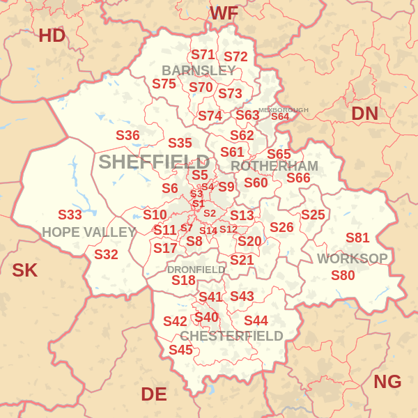
|
| Postcode |
Coverage Area |
Local Authority Area |
| S70 |
Central Barnsley, Birdwell, Stairfoot, Worsborough, Kendray |
Barnsley |
| S71 |
Ardsley, Athersley, Monk Bretton, Lundwood, Royston |
Barnsley |
| S72 |
Brierley, Cudworth, Grimethorpe, Shafton, South Hiendley |
Barnsley, Wakefield |
| S73 |
Brampton, Darfield, Wombwell, Hemingfield |
Barnsley, Rotherham |
| S74 |
Elsecar, Hoyland, Jump, Blacker Hill |
Barnsley |
| S75 |
Barugh Green, Cawthorne, Darton, Dodworth, Gawber, Mapplewell, Pogmoor, Staincross, Wilthorpe, Tankersley, Kexborough |
Barnsley |
| S80 |
Creswell, Thorpe Salvin, South Worksop, Whitwell |
Bassetlaw, Bolsover, Rotherham |
| S81 |
Blyth, Carlton-in-Lindrick, Langold, North Worksop, Shireoaks, Woodsetts |
Bassetlaw, Rotherham |
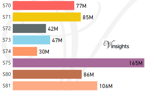
- M represents Million Pounds
- Total value includes Property Type Other apart from Detached, Semi-Detached, Terraced, Flat/Masionette
Schools for Postcode Area S
- Sheffield S Postcode Area - S1, S2, S3, S4, S5, S6, S7, S8, S9 School Details
- S Postcode Area - S10, S11, S12, S13, S14, S17, S18 School Details
- S Postcode Area - S20, S21, S25, S26, S32, S33, S35, S36 School Details
- S Postcode Area - S40, S41, S42, S43, S44, S45 School Details
- S Postcode Area - S60, S61, S62, S63, S64, S65, S66 School Details
- S Postcode Area - S70, S71, S72, S73, S74, S75, S80, S81 School Details
Property Posts for Postcode Area S
42815dcc-7ced-4e4a-9636-6e6e06773142|0|.0|27604f05-86ad-47ef-9e05-950bb762570c
Tags :