22. February 2018 10:36
/
VInsights Team
/
/
Comments (0)
Please click here for the updated version of this post
This Post covers
Coverage Area of Postcode PO18 to PO22
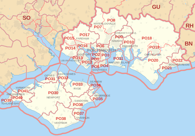 |
| Postcode |
Coverage Area |
Local Authority Area |
| PO18 |
Bosham, Boxgrove, Eartham, East Dean, Goodwood, Funtington, Nutbourne |
Chichester |
| PO19 |
Chichester, Fishbourne |
Chichester |
| PO20 |
Selsey, West Wittering, East Wittering, Tangmere, Oving, Westergate, Eastergate |
Chichester |
| PO21 |
Bognor Regis, Aldwick, Pagham |
Arun |
| PO22 |
Bognor Regis, Barnham, Elmer, Felpham, Middleton-on-Sea |
Arun |
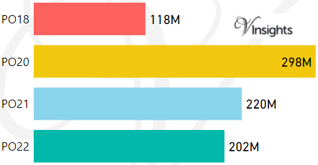
- M represents Million Pounds
- Total value includes Property Type Other apart from Detached, Semi-Detached, Terraced, Flat/Masionette
Schools for Postcode Area PO
- PO Postcode Area - PO1, PO2, PO3, PO4, PO5, PO6, PO7, PO8, PO9 School Details
- PO Postcode Area - PO10, PO11, PO12, PO13, PO14, PO15, PO16, PO17 School Details
- PO Postcode Area - PO18, PO19, PO20, PO21, PO22 School Details
- PO Postcode Area - PO30, PO31, PO32, PO33, PO34, PO35, PO36, PO37, PO38, PO39, PO40, PO41 School Details
Property Posts for Postcode Area PO
All PO Postcodes Yearly & Trend Analysis Posts

Reference
PO Postcode Area As Per Wikipedia
e236e061-744f-4c06-b9b0-8fc3e097af6b|0|.0|27604f05-86ad-47ef-9e05-950bb762570c
Tags :