Please click here for the updated version of this post
This Post covers
- Coverage Area of Postcode OX1 to OX9
- Total Sales By Postcode OX1 to OX9
- Average & Median Sales Price By Postcode OX1 to OX9
- Total Number of Sales By Postcode OX1 to OX9
- Multi Year Property Trend Analysis By Postcode OX1 to OX9
- Schools for Postcode Area OX
- Posts For Postcode Area OX
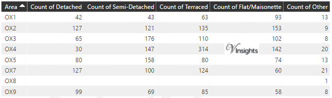
Coverage Area of Postcode OX1 to OX9
 |
| Postcode |
Coverage Area |
Local Authority Area |
| OX1 |
Central and South Oxford, Kennington, Boars Hill, New Hinksey, South Hinksey, Osney |
Oxford, Vale Of White Horse |
| OX2 |
North and West Oxford, Botley, North Hinksey, Summertown, Wytham, Jericho, Wolvercote |
Oxford, Vale Of White Horse, Cherwell |
| OX3 |
North East Oxford, Beckley, Headington, Marston, Elsfield, Noke, Woodeaton, Woodperry |
Oxford, South Oxfordshire, Cherwell |
| OX4 |
East Oxford, Cowley, Blackbird Leys, Littlemore Sandford-on-Thames, Iffley, Rose Hill |
Oxford, South Oxfordshire |
| OX5 |
Kidlington, Yarnton, Begbroke, Tackley, Murcott, Charlton-on-Otmoor, Fencott, Islip |
Cherwell, West Oxfordshire, Aylesbury Vale |
| OX7 |
Chipping Norton, Charlbury, Chadlington, Bledington |
West Oxfordshire, Cotswold |
| OX9 |
Thame, Postcombe, Towersey, North Weston |
South Oxfordshire |
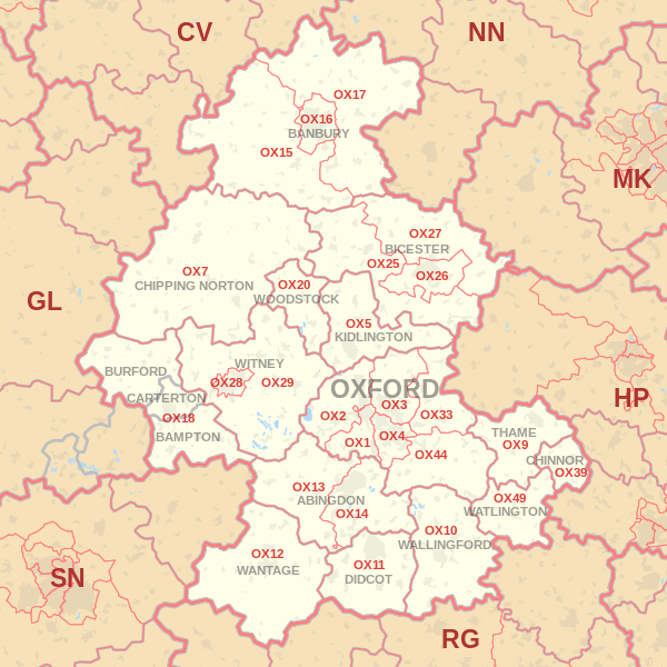
Total Sales By Postcode in 2016
*M represent Million
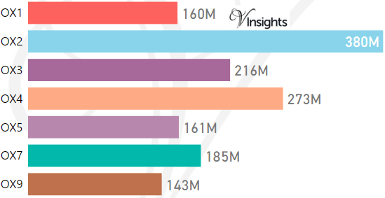
Average & Median Sales Price By Postcode in 2016
*Average and Median Sale Price is in Pounds
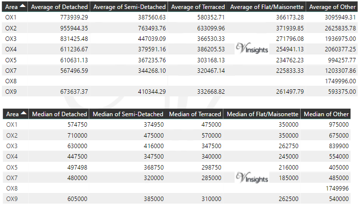
Total Number Of Sales By Postcode in 2016
Multi Year Property Trend Analysis By Postcode
Schools for Postcode Area OX
- OX Postcode Area - OX1, OX2, OX3, OX4, OX5, OX7, OX9 School Details
- OX Postcode Area - OX10, OX11, OX12, OX13, OX14, OX15, OX16, OX17 School Details
- OX Postcode Area - OX18, OX20, OX25, OX26, OX27 School Details
- OX Postcode Area - OX28, OX29, OX33, OX39, OX44, OX49 School Details
Posts for Postcode Area OX
All OX Postcodes Yearly & Trend Analysis Posts

Reference
OX Postcode Area As Per Wikipedia
c840fd21-10a9-4b58-967c-9e69650fe659|0|.0|27604f05-86ad-47ef-9e05-950bb762570c