10. April 2018 09:44
/
VInsights Team
/
/
Comments (0)
Please click here for the updated version of this post
This Post covers
Coverage Area of Postcode NE30 to NE39
|
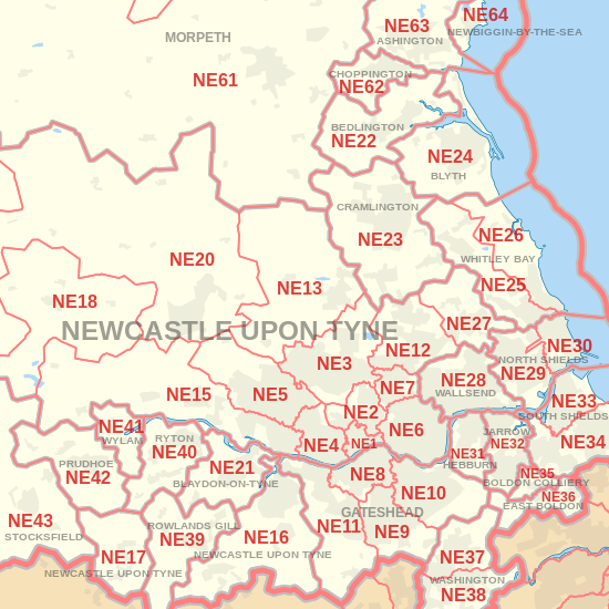
|
| Postcode |
Coverage Area |
Local Authority Area |
| NE30 |
Marden, Tynemouth, Cullercoats |
North Tyneside |
| NE31 |
Hebburn |
South Tyneside |
| NE32 |
Jarrow, Fellgate, South Tyne Tunnel |
South Tyneside |
| NE33 |
Town Centre, Deans, High Shields |
South Tyneside |
| NE34 |
Harton, Horsley Hill, Marsden, Simonside, Brockley Whins |
South Tyneside |
| NE35 |
Boldon Colliery |
South Tyneside |
| NE36 |
East Boldon, West Boldon |
South Tyneside |
| NE37 |
Usworth, Sulgrave, Albany |
Sunderland |
| NE38 |
Town Centre, Oxclose, Fatfield, Harraton |
Sunderland |
| NE39 |
Rowlands Gill, High Spen, Hamsterley Mill, Eastern Chopwell Wood |
Gateshead, County Durham |
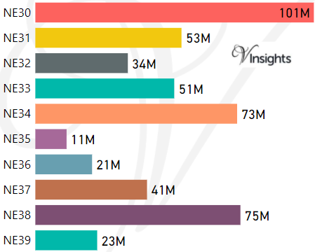
- M represents Million Pounds
- Total value includes Property Type Other apart from Detached, Semi-Detached, Terraced, Flat/Masionette
Schools for Postcode Area NE
- NE Postcode Area - NE1, NE2, NE3, NE4, NE5, NE6, NE7, NE8, NE9 School Details
- NE Postcode Area - NE10, NE11, NE12, NE13, NE15, NE16, NE17, NE18, NE19 School Details
- NE Postcode Area - NE20, NE21, NE22, NE23, NE24, NE25, NE26, NE27, NE28, NE29 School Details
- NE Postcode Area - NE30, NE31, NE32, NE33, NE34, NE35, NE36, NE37, NE38, NE39 School Details
- NE Postcode Area - NE40, NE41, NE42, NE43, NE44, NE45, NE46, NE47, NE48, NE49 School Details
- NE Postcode Area - NE61, NE62, NE63, NE64, NE65, NE66, NE67, NE68, NE69, NE70, NE71 School Details
Property Posts for Postcode Area NE
def1fe28-e066-42d9-9374-305a7e1fe595|0|.0|27604f05-86ad-47ef-9e05-950bb762570c
Tags :