Please click here for the updated version of this post
This Post covers
- Coverage Area of Postcode TW10 to TW20
- Total Sales By Postcode TW10 to TW20
- Average & Median Sales Price By Postcode TW10 to TW20
- Total Number of Sales By Postcode TW10 to TW20
- Multi Year Property Trend Analysis By Postcode TW10 to TW20
- Schools for Postcode Area TW
- Posts for Postcode Area TW
Coverage Area of Postcode TW10 to TW20
 |
| Postcode |
Coverage Area |
Local Authority Area |
| TW10 |
Ham, Petersham, Richmond Hill, North Sheen (south), Richmond Park |
Kingston Upon Thames, Richmond upon Thames |
| TW11 |
Teddington, Fulwell (east), Bushy Park |
Richmond Upon Thames |
| TW12 |
Hampton, Hampton Hill, Fulwell (west) |
Richmond Upon Thames |
| TW13 |
Feltham, Hanworth |
Hounslow, Richmond upon Thames |
| TW14 |
Feltham (part of the station area), North Feltham, East Bedfont, Hatton |
Hillingdon, Hounslow, Spelthorne |
| TW15 |
Ashford |
Hounslow, Spelthorne |
| TW16 |
Sunbury-on-Thames |
Elmbridge, Richmond Upon Thames, Spelthorne |
| TW17 |
Shepperton, Upper Halliford, Charlton, Littleton |
Elmbridge, Spelthorne |
| TW18 |
Staines-upon-Thames, Egham Hythe, Laleham |
Runnymede, Spelthorne, Windsor and Maidenhead |
| TW19 |
Stanwell, Stanwell Moor, Wraysbury, Sunnymeads, Hythe End |
Hillingdon, Spelthorne, Windsor and Maidenhead |
| TW20 |
Egham, Englefield Green, Thorpe |
Runnymede |
Total Sales By Postcode in 2016
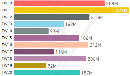
*M represents millions
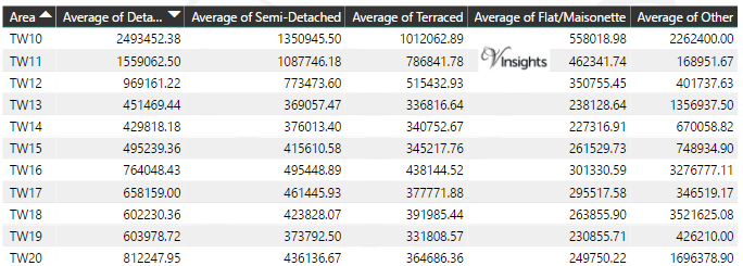
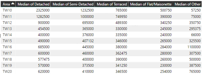
Average & Median Sales Price By Postcode in 2016
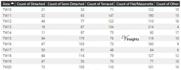
Total Number Of Sales By Postcode in 2016
Multi Year Property Trend Analysis By Postcode
Schools for Postcode Area TW
- London TW Postcode Area - TW1, TW2, TW3, TW4, TW5, TW6, TW7, TW8, TW9 School Details
- London TW Postcode Area - TW10, TW11, TW12, TW13, TW14, TW15, TW16, TW17, TW18, TW19, TW20 School Details
Posts for Postcode Area TW
All TW Postcode Area Posts

Reference
TW Postcode Area As Per Wikipedia
82640488-7d16-4b3c-aab1-a03d38cd9071|0|.0|27604f05-86ad-47ef-9e05-950bb762570c