Please click here for the updated version of this post
This Post covers
- Coverage Area of Postcode LL30 to LL39
- Total Sales By Postcode LL30 to LL39
- Average & Median Sales Price By Postcode LL30 to LL39
- Spread of Sales Price By Postcode LL30 to LL39
- Total Number of Sales By Postcode LL30 to LL39
- Posts for Postcode Area LL
Coverage Area of Postcode LL30 to LL39
|
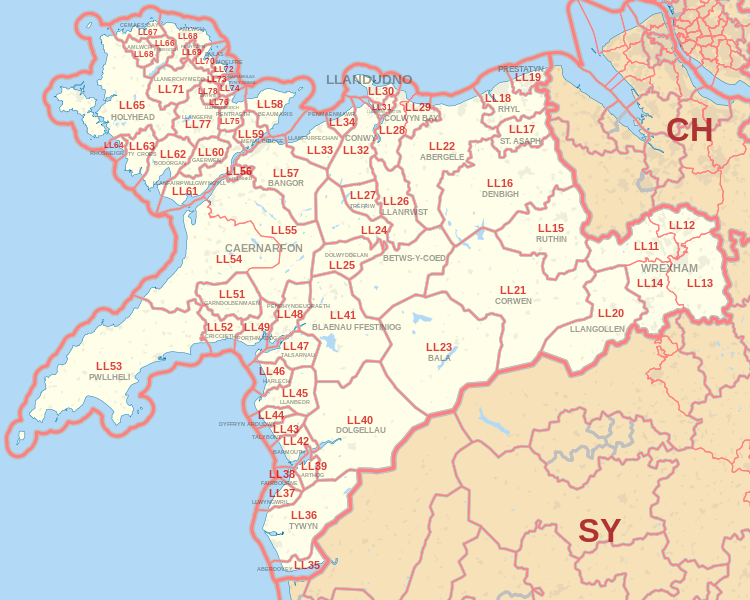
|
| Postcode |
Coverage Area |
Local Authority Area |
| LL30 |
Llanrhos, Llandudno, Penrhyn Bay |
Conwy |
| LL31 |
Glanwydden, Llangwstenin, Llandudno Junction,Deganwy |
Conwy |
| LL32 |
Conwy, Dolgarrog, Groesffordd, Henryd, Rowen, Tal-y-Bont, Tyn-y-Groes |
Conwy |
| LL33 |
Abergwyngregyn, Llanfairfechan |
Conwy, Gwynedd |
| LL34 |
Penmaenmawr, Dwygyfylchi |
Conwy |
| LL35 |
Aberdovey |
Gwynedd |
| LL36 |
Tywyn, Abergynolwyn, Bryncrug, Llanegryn, Rhoslefain |
Gwynedd |
| LL37 |
Llwyngwril |
Gwynedd |
| LL38 |
Fairbourne, Friog |
Gwynedd |
| LL39 |
Arthog |
Gwynedd |
Total Sales By Postcode
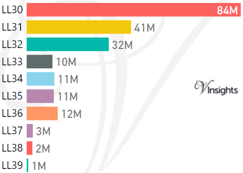
*M represents Million Pounds
Average & Median Sales Price By Postcode
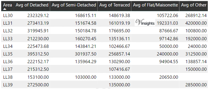
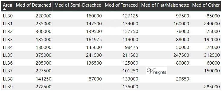
*Average and Median Sales Price are in Pounds
Spread of Sales Price By Postcode
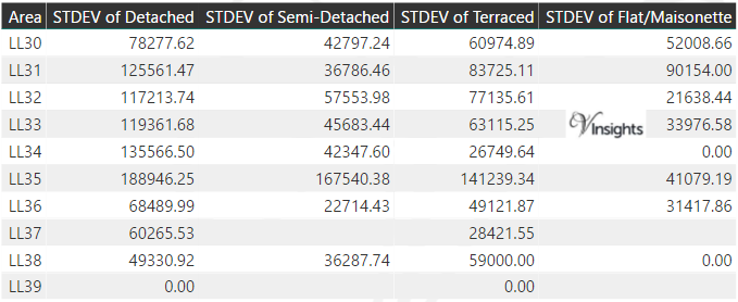
*STDEV is Standard Deviation
For example,
- Say the average detached property price for postcode XYZ is £300 K and ST. DEV. is 30 K.
- It means that most detached properties in postcode XYZ (about 68%) has price within one ST. Dev. i.e. the price range is £270K - £330K.
- All-most all detached property price (95%) in postcode XYZ lie between two ST. Dev. i.e. £240 K - £360 K
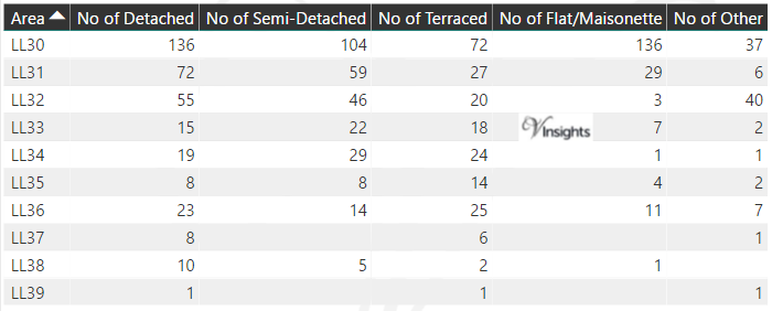
Total Number Of Sales By Postcode
Posts for Postcode Area LL
All Wales Postcode Area Posts

Reference
LL Postcode Area As Per Wikipedia
ae0bfe6c-c4bb-4169-a9e1-0057f487bf29|0|.0|27604f05-86ad-47ef-9e05-950bb762570c