22. April 2018 20:35
/
VInsights Team
/
/
Comments (0)
Please click here for the updated version of this post
This Post covers
Coverage Area of Postcode HU1 to HU9
|
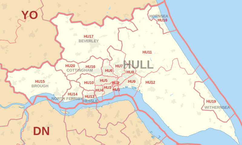
|
| Postcode |
Coverage Area |
Local Authority Area |
| HU1 |
Hull |
Kingston upon Hull |
| HU2 |
Hull |
Kingston upon Hull |
| HU3 |
Hull, Spring Bank |
Kingston upon Hull |
| HU4 |
Hull, Anlaby Common, Anlaby Park, Gipsyville |
Kingston upon Hull |
| HU5 |
Hull, The Avenues |
Kingston upon Hull |
| HU6 |
Hull, Dunswell, Orchard Park, Greenwood |
Kingston upon Hull |
| HU7 |
Hull, Bransholme, Kingswood, Sutton-on-Hull, Wawne |
Kingston upon Hull |
| HU8 |
Hull, Garden Village, Ings, Longhill, Sutton-on-Hull |
Kingston upon Hull |
| HU9 |
Hull, Drypool, Victoria Dock, Marfleet, Preston Road, Greatfield, Bilton Grange |
Kingston upon Hull |
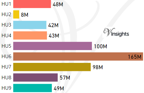
- M represents Million Pounds
- Total value includes Property Type Other apart from Detached, Semi-Detached, Terraced, Flat/Masionette
Schools for Postcode Area HU
- HU Postcode Area - HU1, HU2, HU3, HU4, HU5, HU6, HU7, HU8, HU9 School Details
- HU Postcode Area - HU10, HU11, HU12, HU13, HU14, HU15, HU16, HU17, HU18, HU19, HU20 School Details
Property Posts for Postcode Area HU
526befab-8c33-46e9-8704-2614bab12a29|0|.0|27604f05-86ad-47ef-9e05-950bb762570c
Tags :