Please click here for the updated version of this post
This Post covers
- Coverage Area of Postcode HP10 to HP16
- Total Sales By Postcode HP10 to HP16
- Average & Median Sales Price By Postcode HP10 to HP16
- Total Number of Sales By Postcode HP10 to HP16
- Multi Year Property Trend Analysis By Postcode HP10 to HP16
- Schools for Postcode Area HP
- Posts for Postcode Area HP
Coverage Area of Postcode HP10 to HP16
 |
| Postcode |
Coverage Area |
Local Authority Area |
| HP10 |
High Wycombe, Flackwell Heath, Handy Cross, Hedsor, Loudwater,Penn, Tylers Green, Wooburn, Wooburn Green, Wooburn Moor
|
Wycombe, Chiltern |
| HP11 |
Wycombe Marsh |
Wycombe |
| HP12 |
High Wycombe, Booker, Sands |
Wycombe |
| HP13 |
High Wycombe, Downley, Totteridge |
Wycombe |
| HP14 |
Beacon's Bottom, Bledlow Ridge, Bolter End, Bradenham, Cadmore End, Hughenden Valley, Ibstone, Lane End, Naphill, Northend, Stokenchurch, The City, Upper North Dean, West Wycombe |
Wycombe |
| HP15 |
Cryers Hill, Great Kingshill, Hazlemere, Holmer Green, Hughenden Valley |
Wycombe, Chiltern |
| HP16 |
Great Missenden, Ballinger, The Lee, Little Hampden, Little Kingshill, Prestwood, South Heath |
Wycombe, Chiltern |
Total Sales By Postcode in 2016
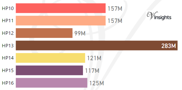
*M represents millions
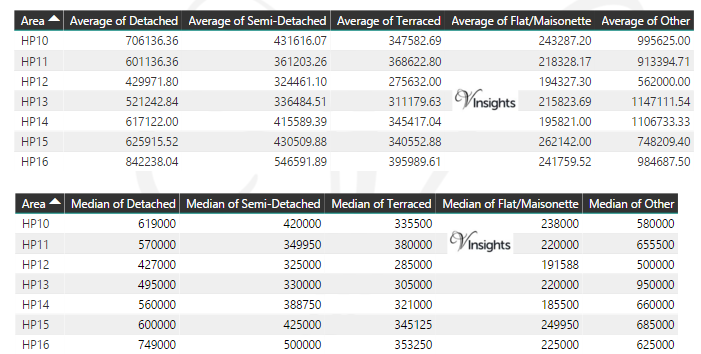
Average & Median Sales Price By Postcode in 2016
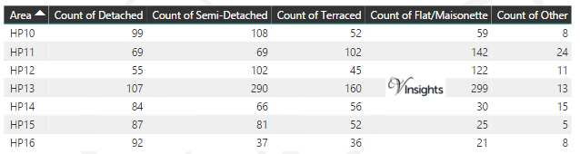
Total Number Of Sales By Postcode in 2016
Multi Year Property Trend Analysis By Postcode
Schools for Postcode Area HP
- HP Postcode Area - HP1, HP2, HP3, HP4 School Details
- HP Postcode Area - HP5, HP6, HP7, HP8, HP9 School Details
- HP Postcode Area - HP10, HP11, HP12, HP13, HP14,HP15,HP16 School Details
- HP Postcode Area - HP17, HP18, HP19, HP20, HP21, HP22, HP23, HP27 School Details
Posts for Postcode Area HP
All HP Postcodes Yearly & Trend Analysis Posts

Reference
HP Postcode Area As Per Wikipedia
d58f18d0-1147-48cd-800e-eaa459f0807e|0|.0|27604f05-86ad-47ef-9e05-950bb762570c