Please click here for the updated version of this post
This Post covers
- Coverage Area of Postcode DL10 to DL17
- Total Sales By Postcode DL10 to DL17
- Average & Median Sales Price By Postcode DL10 to DL17
- Spread of Sales Price By Postcode DL10 to DL17
- Total Number of Sales By Postcode DL10 to DL17
- Property Posts for Postcode Area DL
- Schools for Postcode Area DL
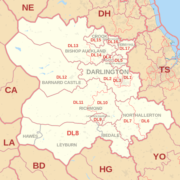
Coverage Area of Postcode DL10 to DL17
|
|
| Postcode |
Coverage Area |
Local Authority Area |
| DL10 |
Richmond, Catterick, Brompton-upon-Swale & Scotch Corner |
North Yorkshire |
| DL11 |
Swaledale, Reeth, Low Row & Arkengarthdale |
North Yorkshire, Cumbria |
| DL12 |
Barnard Castle, Bowes & Middleton-in-Teesdale |
County Durham |
| DL13 |
Stanhope, Frosterley, Wolsingham & Tow Law |
County Durham, Cumbria |
| DL14 |
Bishop Auckland & Evenwood |
County Durham |
| DL15 |
Crook & Willington |
County Durham |
| DL16 |
Spennymoor |
County Durham |
| DL17 |
Ferryhill, Chilton, Cornforth & Bishop Middleham |
County Durham |
Total Sales By Postcode
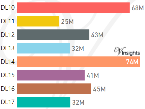
*M represents Million Pounds
Average & Median Sales Price By Postcode
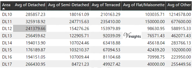
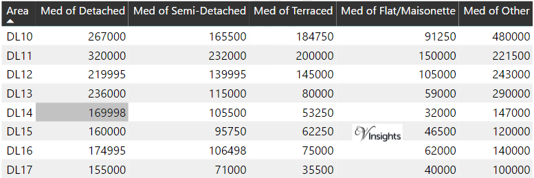
*Average and Median Sales Price are in Pounds
Spread of Sales Price By Postcode
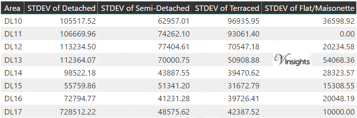
*STDEV is Standard Deviation
For example,
- Say the average detached property price for postcode XYZ is £300 K and ST. DEV. is 30 K.
- It means that most detached properties in postcode XYZ (about 68%) has price within one ST. Dev. i.e. the price range is £270K - £330K.
- All-most all detached property price (95%) in postcode XYZ lie between two ST. Dev. i.e. £240 K - £360 K
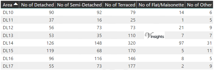
Total Number Of Sales By Postcode
Property Posts for Postcode Area DL
Schools for Postcode Area DL
- DL Postcode Area - DL1, DL2, DL3, DL4, DL5, DL6, DL7, DL8, DL9 School Details
- DL Postcode Area - DL10, DL11, DL12, DL13, DL14, DL15, DL16, DL17 School Details
All Yorkshire & Humber Postcode Area Posts

Reference
DL Postcode Area As Per Wikipedia
979ff7d3-a94e-42cc-af84-ef1adcf7f3ab|0|.0|27604f05-86ad-47ef-9e05-950bb762570c