18. February 2018 20:54
/
VInsights Team
/
/
Comments (0)
Please click here for the updated version of this post
This Post covers
Coverage Area of Postcode CT1 to CT9
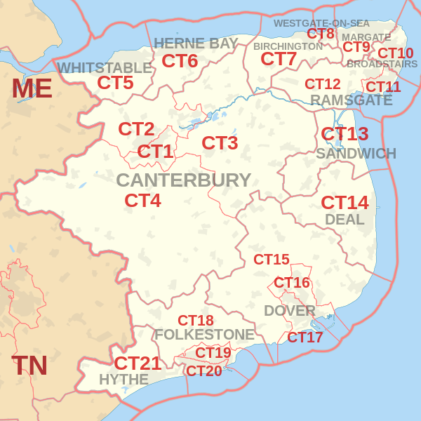 |
| Postcode |
Coverage Area |
Local Authority Area |
| CT1 |
Canterbury (south and city centre) |
Canterbury |
| CT2 |
Canterbury (north), Harbledown, Rough Common, Sturry, Fordwich, Blean, Tyler Hill, Broad Oak, Westbere |
Canterbury |
| CT3 |
Wingham |
Canterbury, Dover |
| CT4 |
Chartham, Bridge` |
Canterbury, Ashford |
| CT5 |
Whitstable, Seasalter, Tankerton, Chestfield, Swalecliffe, Yorkletts |
Canterbury |
| CT6 |
Herne Bay, Herne, Broomfield, Greenhill, Eddington, Beltinge, Reculver |
Canterbury |
| CT7 |
Birchington-on-Sea, St Nicholas-at-Wade, Sarre, Acol |
Thanet |
| CT8 |
Westgate-on-Sea |
Thanet |
| CT9 |
Margate, Cliftonville, Birchington |
Thanet |
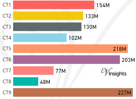
- M represents Million Pounds
- Total value includes Property Type Other apart from Detached, Semi-Detached, Terraced, Flat/Masionette
Schools for Postcode Area CT
- CT Postcode Area - CT1, CT2, CT3, CT4, CT5, CT6, CT7, CT8, CT9 School Details
- CT Postcode Area - CT10, CT11, CT12, CT13, CT14, CT15, CT16, CT17 School Details
- CT Postcode Area - CT18, CT19, CT20, CT21 School Details
Property Posts for Postcode Area CT
All CT Postcodes Yearly & Trend Analysis Posts

Reference
CT Postcode Area As Per Wikipedia
2249dc43-de39-4c7a-9226-b53775ce30a9|0|.0|27604f05-86ad-47ef-9e05-950bb762570c
Tags :