22. April 2018 22:49
/
VInsights Team
/
/
Comments (0)
Please click here for the updated version of this post
This Post covers
Coverage Area of Postcode LS1 to LS9
|
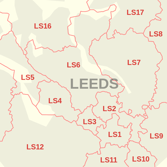
|
| Postcode |
Coverage Area |
Local Authority Area |
| LS1 |
Leeds city centre |
Leeds |
| LS2 |
Leeds city centre, Woodhouse |
Leeds |
| LS3 |
Burley, Kirkstall, Woodhouse |
Leeds |
| LS4 |
Burley, Kirkstall |
Leeds |
| LS5 |
Hawksworth, Kirkstall |
Leeds |
| LS6 |
Beckett Park, Burley, Headingley, Hyde Park, Meanwood, Woodhouse |
Leeds |
| LS7 |
Beck Hill, Buslingthorpe, Chapel Allerton, Chapeltown, Little London, Lovell Park, Meanwood, Miles Hill, Potternewton, Scott Hall, Sheepscar |
Leeds |
| LS8 |
Fearnville, Gipton, Gledhow, Harehills, Oakwood, Roundhay |
Leeds |
| LS9 |
Burmantofts, Cross Green, East End Park, Gipton, Harehills, Mabgate, Osmondthorpe, Richmond Hill, Halton Moor |
Leeds |
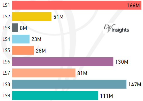
- M represents Million Pounds
- Total value includes Property Type Other apart from Detached, Semi-Detached, Terraced, Flat/Masionette
Schools for Postcode Area LS
- Leeds LS Postcode Area - LS1, LS2, LS3, LS4, LS5, LS6, LS7, LS8, LS9 School Details
- Leeds LS Postcode Area - LS10, LS11, LS12, LS13, LS14, LS15, LS16, LS17, LS18, LS19 School Details
- Leeds LS Postcode Area - LS20, LS21, LS22, LS23, LS24, LS25, LS26, LS27, LS28, LS29 School Details
Property Posts for Postcode Area LS
2fbcbe77-3acb-49b2-9af2-5df0e0a5bdad|0|.0|27604f05-86ad-47ef-9e05-950bb762570c
Tags :
22. April 2018 22:36
/
VInsights Team
/
/
Comments (0)
Please click here for the updated version of this post
This Post covers
Coverage Area of Postcode HX1 to HX7
|
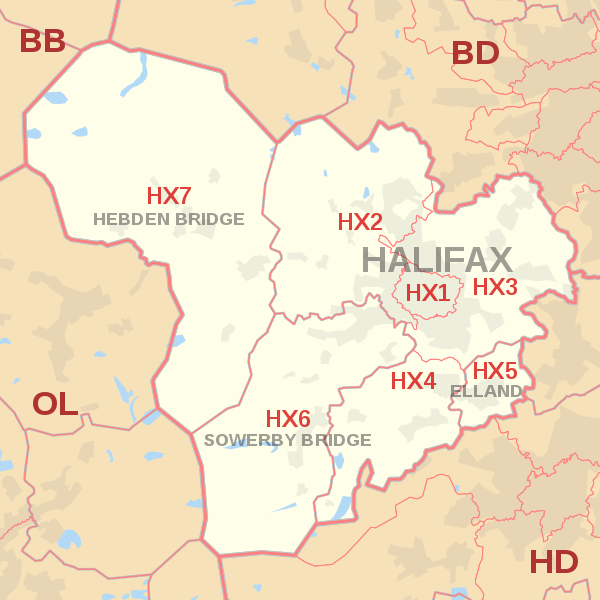
|
| Postcode |
Coverage Area |
Local Authority Area |
| HX1 |
Halifax Town Centre, Savile Park |
Calderdale |
| HX2 |
Highroad Well, Illingworth, Luddenden, Luddenden Foot,
Midgley, Mixenden, Mount Tabor, Norton Tower, Ogden,
Wainstalls, Warley Town |
Calderdale |
| HX3 |
Boothtown, Hipperholme, Lightcliffe, Norwood Green,
Northowram, Ovenden, Shelf, Skircoat Green, Southowram |
Calderdale |
| HX4 |
Barkisland, Greetland, Holywell Green,Sowood,Stainland,
West Vale |
Calderdale, Bradford |
| HX5 |
Elland, Blackley |
Calderdale |
| HX6 |
Norland, Ripponden, Rishworth, Sowerby, Sowerby Bridge |
Calderdale |
| HX7 |
Cragg Vale, Hebden Bridge, Heptonstall, Mytholmroyd, Old Town |
Calderdale |
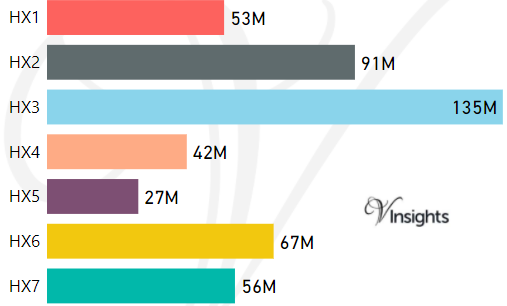
- M represents Million Pounds
- Total value includes Property Type Other apart from Detached, Semi-Detached, Terraced, Flat/Masionette
Schools for Postcode Area HX
Property Posts for Postcode Area HX
279e0304-3d45-421e-991e-e574807db8e7|0|.0|27604f05-86ad-47ef-9e05-950bb762570c
Tags :
22. April 2018 22:16
/
VInsights Team
/
/
Comments (0)
Please click here for the updated version of this post
This Post covers
Coverage Area of Postcode HU10 to HU20
|
|
| Postcode |
Coverage Area |
Local Authority Area |
| HU10 |
Anlaby, Kirk Ella, West Ella, Willerby |
East Riding Of Yorkshire |
| HU11 |
Bilton |
East Riding Of Yorkshire |
| HU12 |
Hedon, Patrington, Preston |
East Riding Of Yorkshire |
| HU13 |
Hessle |
East Riding Of Yorkshire |
| HU14 |
North Ferriby, Melton, Swanland |
East Riding Of Yorkshire |
| HU15 |
Elloughton-cum-Brough, South Cave, Welton |
East Riding Of Yorkshire |
| HU16 |
Cottingham, Eppleworth, Raywell, Skidby |
East Riding Of Yorkshire |
| HU17 |
Beverley, Bishop Burton, Walkington |
East Riding Of Yorkshire |
| HU18 |
Hornsea, Mappleton, Rolston |
East Riding Of Yorkshire |
| HU19 |
Withernsea, Hollym, Holmpton,
Out Newton, Rimswell, Waxholme |
East Riding Of Yorkshire |
| HU20 |
High Hunsley, Little Weighton, Low Hunsley, Riplingham |
East Riding Of Yorkshire |

- M represents Million Pounds
- Total value includes Property Type Other apart from Detached, Semi-Detached, Terraced, Flat/Masionette
Schools for Postcode Area HU
- HU Postcode Area - HU1, HU2, HU3, HU4, HU5, HU6, HU7, HU8, HU9 School Details
- HU Postcode Area - HU10, HU11, HU12, HU13, HU14, HU15, HU16, HU17, HU18, HU19, HU20 School Details
Property Posts for Postcode Area HU
37619b4f-b34a-4f9b-831c-6e2a59dcb83a|0|.0|27604f05-86ad-47ef-9e05-950bb762570c
Tags :
22. April 2018 20:35
/
VInsights Team
/
/
Comments (0)
Please click here for the updated version of this post
This Post covers
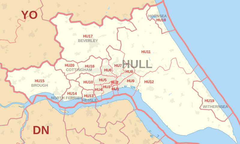
Coverage Area of Postcode HU1 to HU9
|
|
| Postcode |
Coverage Area |
Local Authority Area |
| HU1 |
Hull |
Kingston upon Hull |
| HU2 |
Hull |
Kingston upon Hull |
| HU3 |
Hull, Spring Bank |
Kingston upon Hull |
| HU4 |
Hull, Anlaby Common, Anlaby Park, Gipsyville |
Kingston upon Hull |
| HU5 |
Hull, The Avenues |
Kingston upon Hull |
| HU6 |
Hull, Dunswell, Orchard Park, Greenwood |
Kingston upon Hull |
| HU7 |
Hull, Bransholme, Kingswood, Sutton-on-Hull, Wawne |
Kingston upon Hull |
| HU8 |
Hull, Garden Village, Ings, Longhill, Sutton-on-Hull |
Kingston upon Hull |
| HU9 |
Hull, Drypool, Victoria Dock, Marfleet, Preston Road, Greatfield, Bilton Grange |
Kingston upon Hull |
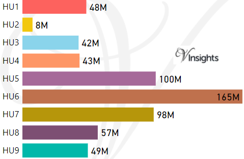
- M represents Million Pounds
- Total value includes Property Type Other apart from Detached, Semi-Detached, Terraced, Flat/Masionette
Schools for Postcode Area HU
- HU Postcode Area - HU1, HU2, HU3, HU4, HU5, HU6, HU7, HU8, HU9 School Details
- HU Postcode Area - HU10, HU11, HU12, HU13, HU14, HU15, HU16, HU17, HU18, HU19, HU20 School Details
Property Posts for Postcode Area HU
526befab-8c33-46e9-8704-2614bab12a29|0|.0|27604f05-86ad-47ef-9e05-950bb762570c
Tags :
22. April 2018 20:20
/
VInsights Team
/
/
Comments (0)
Please click here for the updated version of this post
This Post covers
Coverage Area of Postcode HG1 to HG5
|

|
| Postcode |
Coverage Area |
Local Authority Area |
| HG1 |
Central, Bilton, Jennyfields, Duchy, New Park |
Harrogate |
| HG2 |
Oatlands, Woodlands, Hookstone, Rossett,
Pannal Ash, Harlow Hill, Hornbeam Park |
Harrogate |
| HG3 |
Pannal, Killinghall, Spofforth, Bishop Monkton,
Glasshouses, Follifoot, Pateley Bridge |
Harrogate |
| HG4 |
Ripon, North Stainley, High Grantley, Masham,
West Tanfield, Thornton Watlass, Thornton Steward |
Harrogate, Hambleton,
Richmondshire |
| HG5 |
Scotton, Knaresborough |
Harrogate |
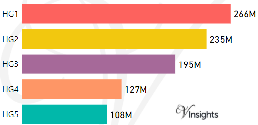
- M represents Million Pounds
- Total value includes Property Type Other apart from Detached, Semi-Detached, Terraced, Flat/Masionette
Schools for Postcode Area HG
Property Posts for Postcode Area HG
bcd3f292-da37-4612-a1a6-f186a2435158|0|.0|27604f05-86ad-47ef-9e05-950bb762570c
Tags :