27. April 2018 13:45
/
VInsights Team
/
/
Comments (0)
Please click here for the updated version of this post
This Post covers
Coverage Area of Postcode CF3 to CF15
|
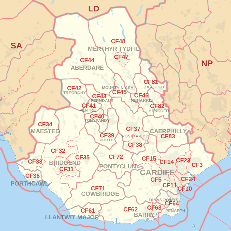
|
| Postcode |
Coverage Area |
Local Authority Area |
| CF3 |
CARDIFF SOUTH (East):Rumney & Trowbridge, Llanrumney, St Mellons
NEWPORT WEST: Castleton, Marshfield |
Cardiff, Newport |
| CF5 |
CARDIFF WEST (South):Ely, Caerau, St Fagans, Culverhouse Cross, Canton & Leckwith, Fairwater, Danescourt, Llandaff, Riverside
VALE OF GLAMORGAN:Wenvoe, Peterston Super Ely, St Georges Super Ely, Michaelston
|
Cardiff, Vale of Glamorgan |
| CF10 |
CARDIFF CENTRAL / CARDIFF SOUTH:CARDIFF CITY CENTRE (part of), Grangetown, CARDIFF BAY (part of) & Butetown |
Cardiff |
| CF11 |
CARDIFF CENTRAL / CARDIFF SOUTH:CARDIFF CITY CENTRE (part of), Canton, CARDIFF BAY (part of), Grangetown |
Cardiff |
| CF14 |
CARDIFF NORTH (West):Birchgrove, Whitchurch, Thornhill & Lisvane, Rhiwbina & Pantmawr, Gabalfa, Heath, Llandaff North, Llanishen |
Cardiff |
| CF15 |
CARDIFF WEST (North):Pentyrch & Gwaelod-y-Garth & Creigiau, Radyr & Morganstown, Tongwynlais
Rhondda Cynon Taff:TAFFS WELL & Nantgarw
Caerphilly:Groeswen
|
Cardiff, Rhondda Cynon Taff, Caerphilly |
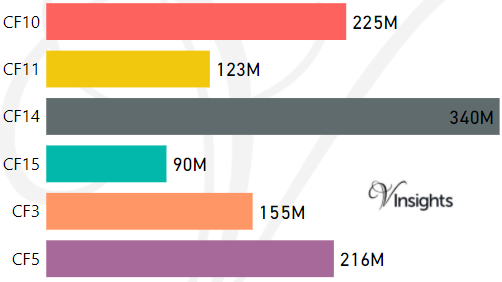
- M represents Million Pounds
- Total value includes Property Type Other apart from Detached, Semi-Detached, Terraced, Flat/Masionette
Property Posts for Postcode Area CF
90a8b5cc-85b7-4f22-9bdb-dcf747957e92|0|.0|27604f05-86ad-47ef-9e05-950bb762570c
Tags :
24. April 2018 17:46
/
VInsights Team
/
/
Comments (0)
Please click here for the updated version of this post
This Post covers
Coverage Area of Postcode YO41 to YO90
|
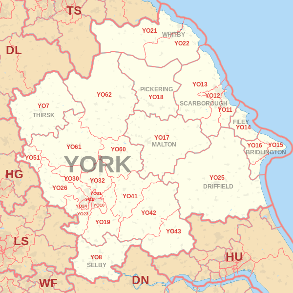
|
| Postcode |
Coverage Area |
Local Authority Area |
| YO41 |
Elvington, Full Sutton, Stamford Bridge, Sutton upon Derwent, Wilberfoss |
East Riding of Yorkshire, York |
| YO42 |
Pocklington, Barmby Moor, Melbourne, Seaton Ross |
East Riding Of Yorkshire |
| YO43 |
Market Weighton, Holme-on-Spalding-Moor |
East Riding Of Yorkshire |
| YO51 |
Boroughbridge |
North Yorkshire County Council |
| YO60 |
Sheriff Hutton |
Ryedale |
| YO61 |
Easingwold |
Hambleton |
| YO62 |
Helmsley, Kirkbymoorside, Nawton |
Ryedale |
| YO90 |
Rougier St, Wellington Row |
York |
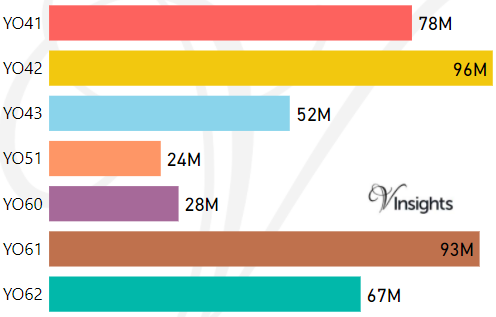
- M represents Million Pounds
- Total value includes Property Type Other apart from Detached, Semi-Detached, Terraced, Flat/Masionette
Schools for Postcode Area YO
- YO Postcode Area - YO1, YO7, YO8, YO10, YO11, YO12, YO13, YO14 School Details
- YO Postcode Area - YO15, YO16, YO17, YO18, YO19, YO21, YO22 School Details
- YO Postcode Area - YO23, YO24, YO25, YO26, YO30, YO31, YO32 School Details
- YO Postcode Area - YO41, YO42, YO43, YO51, YO60, YO61, YO62, YO90 School Details
Property Posts for Postcode Area YO
77a6fa12-0e6f-4961-ae32-bb5f6cb03d71|0|.0|27604f05-86ad-47ef-9e05-950bb762570c
Tags :
24. April 2018 17:39
/
VInsights Team
/
/
Comments (0)
Please click here for the updated version of this post
This Post covers
Coverage Area of Postcode YO23 to YO32
|
|
| Postcode |
Coverage Area |
Local Authority Area |
| YO23 |
South Bank, Bishopthorpe, Copmanthorpe, Rufforth |
City of York Council |
| YO24 |
Acomb, Dringhouses, Woodthorpe |
City of York Council |
| YO25 |
Driffield |
East Riding Of Yorkshire |
| YO26 |
Acomb, Leeman Road Area, Upper Poppleton, Nether Poppleton, Green Hammerton |
City of York Council |
| YO30 |
Bootham, Clifton, Skelton, Linton-on-Ouse |
City of York Council |
| YO31 |
Heworth, Huntington (South), The Groves, Layerthorpe |
City of York Council |
| YO32 |
Haxby, Huntington (North), Wigginton, New Earswick, Stockton-on-the-Forest, Strensall |
City of York Council |
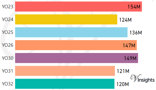
- M represents Million Pounds
- Total value includes Property Type Other apart from Detached, Semi-Detached, Terraced, Flat/Masionette
Schools for Postcode Area YO
- YO Postcode Area - YO1, YO7, YO8, YO10, YO11, YO12, YO13, YO14 School Details
- YO Postcode Area - YO15, YO16, YO17, YO18, YO19, YO21, YO22 School Details
- YO Postcode Area - YO23, YO24, YO25, YO26, YO30, YO31, YO32 School Details
- YO Postcode Area - YO41, YO42, YO43, YO51, YO60, YO61, YO62, YO90 School Details
Property Posts for Postcode Area YO
4b0f87fb-1634-452a-9301-b8f5fbb50e30|0|.0|27604f05-86ad-47ef-9e05-950bb762570c
Tags :
24. April 2018 17:25
/
VInsights Team
/
/
Comments (0)
Please click here for the updated version of this post
This Post covers
Coverage Area of Postcode YO15 to YO22
|
|
| Postcode |
Coverage Area |
Local Authority Area |
| YO15 |
Bridlington, Bempton, Buckton, Carnaby, Flamborough, Fraisthorpe, Sewerby, Wilsthorpe |
East Riding Of Yorkshire |
| YO16 |
Bridlington, Bempton, Bessingby, Boynton, Buckton, Carnaby, Grindale, Sewerby |
East Riding Of Yorkshire |
| YO17 |
Norton |
Ryedale |
| YO18 |
Pickering, Thornton-le-Dale |
Ryedale |
| YO19 |
Dunnington, Escrick, Wheldrake, Murton, Riccall, Stillingfleet, Warthill |
York,Selby |
| YO21 |
Whitby, Westerdale |
Scarborough |
| YO22 |
Robin Hood's Bay |
Scarborough |
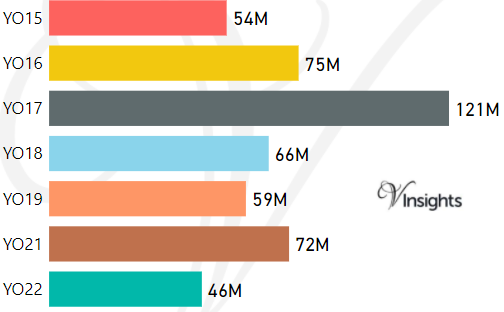
- M represents Million Pounds
- Total value includes Property Type Other apart from Detached, Semi-Detached, Terraced, Flat/Masionette
Schools for Postcode Area YO
- YO Postcode Area - YO1, YO7, YO8, YO10, YO11, YO12, YO13, YO14 School Details
- YO Postcode Area - YO15, YO16, YO17, YO18, YO19, YO21, YO22 School Details
- YO Postcode Area - YO23, YO24, YO25, YO26, YO30, YO31, YO32 School Details
- YO Postcode Area - YO41, YO42, YO43, YO51, YO60, YO61, YO62, YO90 School Details
Property Posts for Postcode Area YO
f0bd6329-dd23-44d4-84ac-a5cd6f5702e8|0|.0|27604f05-86ad-47ef-9e05-950bb762570c
Tags :
24. April 2018 17:16
/
VInsights Team
/
/
Comments (0)
Please click here for the updated version of this post
This Post covers
Coverage Area of Postcode YO1 to YO14
|
|
| Postcode |
Coverage Area |
Local Authority Area |
| YO1 |
City Centre |
York |
| YO7 |
Dalton, Hambleton, Thirsk, Topcliffe |
Hambleton,Harrogate |
| YO8 |
Barlby, Brayton, Bubwith, Cawood, Camblesforth, Drax, Thorpe Willoughby |
|
| YO10 |
Fishergate, Fulford, Heslington, Osbaldwick, Tang Hall |
York |
| YO11 |
Cayton |
Scarborough |
| YO12 |
Seamer |
Scarborough |
| YO13 |
Scarborough |
Scarborough |
| YO14 |
Filey |
Scarborough |
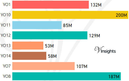
- M represents Million Pounds
- Total value includes Property Type Other apart from Detached, Semi-Detached, Terraced, Flat/Masionette
Schools for Postcode Area YO
- YO Postcode Area - YO1, YO7, YO8, YO10, YO11, YO12, YO13, YO14 School Details
- YO Postcode Area - YO15, YO16, YO17, YO18, YO19, YO21, YO22 School Details
- YO Postcode Area - YO23, YO24, YO25, YO26, YO30, YO31, YO32 School Details
- YO Postcode Area - YO41, YO42, YO43, YO51, YO60, YO61, YO62, YO90 School Details
Property Posts for Postcode Area YO
6ab48c58-0a2c-4160-9392-89da17f4f3d2|0|.0|27604f05-86ad-47ef-9e05-950bb762570c
Tags :