Please click here for the updated version of this post
This Post covers
- Coverage Area of Postcode HP10 to HP16
- Total Sales By Postcode HP10 to HP16
- Average & Median Sales Price By Postcode HP10 to HP16
- Total Number of Sales By Postcode HP10 to HP16
- Multi Year Property Trend Analysis By Postcode HP10 to HP16
- Schools for Postcode Area HP
- Posts for Postcode Area HP
Coverage Area of Postcode HP10 to HP16
 |
| Postcode |
Coverage Area |
Local Authority Area |
| HP10 |
High Wycombe, Flackwell Heath, Handy Cross, Hedsor, Loudwater,Penn, Tylers Green, Wooburn, Wooburn Green, Wooburn Moor
|
Wycombe, Chiltern |
| HP11 |
Wycombe Marsh |
Wycombe |
| HP12 |
High Wycombe, Booker, Sands |
Wycombe |
| HP13 |
High Wycombe, Downley, Totteridge |
Wycombe |
| HP14 |
Beacon's Bottom, Bledlow Ridge, Bolter End, Bradenham, Cadmore End, Hughenden Valley, Ibstone, Lane End, Naphill, Northend, Stokenchurch, The City, Upper North Dean, West Wycombe |
Wycombe |
| HP15 |
Cryers Hill, Great Kingshill, Hazlemere, Holmer Green, Hughenden Valley |
Wycombe, Chiltern |
| HP16 |
Great Missenden, Ballinger, The Lee, Little Hampden, Little Kingshill, Prestwood, South Heath |
Wycombe, Chiltern |
Total Sales By Postcode in 2016
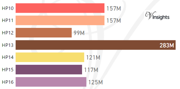
*M represents millions
Average & Median Sales Price By Postcode in 2016
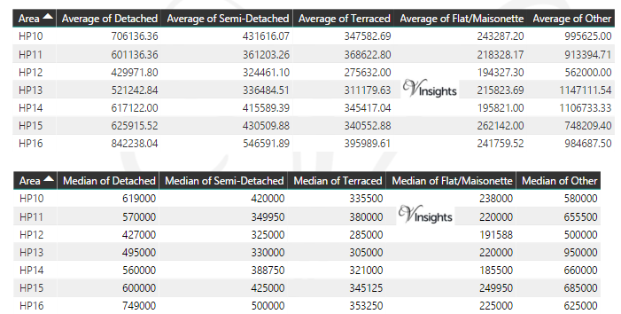
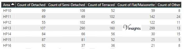
Total Number Of Sales By Postcode in 2016
Multi Year Property Trend Analysis By Postcode
Schools for Postcode Area HP
- HP Postcode Area - HP1, HP2, HP3, HP4 School Details
- HP Postcode Area - HP5, HP6, HP7, HP8, HP9 School Details
- HP Postcode Area - HP10, HP11, HP12, HP13, HP14,HP15,HP16 School Details
- HP Postcode Area - HP17, HP18, HP19, HP20, HP21, HP22, HP23, HP27 School Details
Posts for Postcode Area HP
All HP Postcodes Yearly & Trend Analysis Posts

Reference
HP Postcode Area As Per Wikipedia
d58f18d0-1147-48cd-800e-eaa459f0807e|0|.0|27604f05-86ad-47ef-9e05-950bb762570c
Please click here for the updated version of this post
This Post covers
- Coverage Area of Postcode W10 to W14
- Total Sales By Postcode W10 to W14
- Average & Median Sales Price By Postcode W10 to W14
- Total Number of Sales By Postcode W10 to W14
- Multi Year Property Trend Analysis By Postcode W10 to W14
- Schools for Postcode Area W
- Posts for Postcode Area W
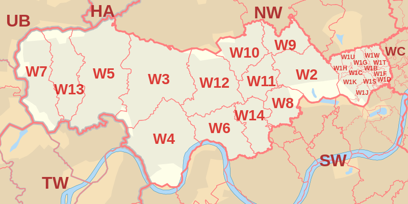
Coverage Area of Postcode W10 to W14
 |
| Postcode |
Coverage Area |
Local Authority Area |
| W10 |
North Kensington, Kensal Town, Ladbroke Grove (north), Queen's Park (part) |
Kensington and Chelsea, Westminster, Hammersmith and Fulham, Brent |
| W11 |
Notting Hill, Ladbroke Grove (south), Holland Park (part) |
Kensington and Chelsea, Westminster, Hammersmith and Fulham |
| W12 |
Shepherds Bush, White City, Wormwood Scrubs, East Acton (east) |
Hammersmith and Fulham |
| W13 |
West Ealing, Northfields (north and west) |
Ealing |
| W14 |
West Kensington, Kensington Olympia, Holland Park |
Hammersmith and Fulham, Kensington and Chelsea |
Total Sales By Postcode in 2016
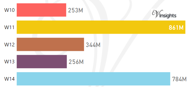
The Total Sales by the Postcodes are:
- W10 £253 millions, W11 £861 millions , W12 £344 millions
- W13 £256 millions, W14 £784 millions
Average & Median Sales Price By Postcode in 2016
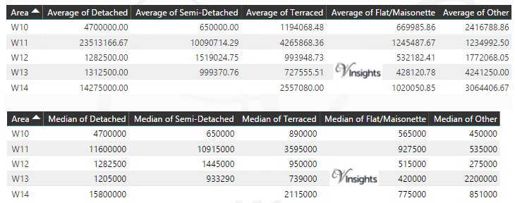
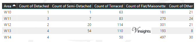
Total Number Of Sales By Postcode in 2016
Multi Year Property Trend Analysis By Postcode
Schools for Postcode Area W
- London W Postcode Area - W1B, W1C, W1D, W1F, W1G, W1H, W1J, W1K, W1S, W1T, W1U, W1W School Details
- London W Postcode Area - W2, W3, W4, W5, W6, W7, W8, W9 School Details
- London W Postcode Area - W10, W11, W12, W13, W14 School Details
Posts for Postcode Area W
All Postcode Area Posts
Reference
W Postcode Area As Per Wikipedia
88f6b1c0-a2bf-4449-9848-38871f9b49d7|0|.0|27604f05-86ad-47ef-9e05-950bb762570c
Please click here for the updated version of this post
This Post covers
- Coverage Area of Postcode W2 to W9
- Total Sales By Postcode W2 to W9
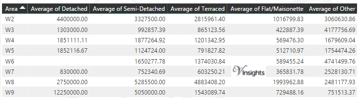
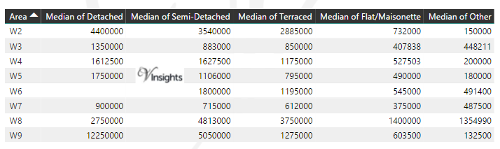
- Average & Median Sales Price By Postcode W2 to W9
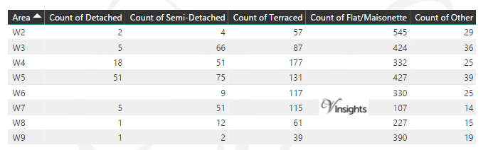
- Total Number of Sales By Postcode W2 to W9
- Multi Year Property Trend Analysis By Postcode W2 to W9
- Schools for Postcode Area W
- Posts for Postcode Area W
Coverage Area of Postcode W2 to W9
|
| Postcode |
Coverage Area |
Local Authority Area |
| W2 |
Paddington, Bayswater, Hyde Park, Westbourne Green, Little Venice (part), Notting Hill (part) |
Westminster, Kensington and Chelsea |
| W3 |
Acton, West Acton, North Acton (part), South Acton, East Acton (west), Park Royal (south), Hanger Hill Garden Estate, Gunnersbury Park |
Ealing, Hounslow, Hammersmith and Fulham |
| W4 |
Chiswick, Gunnersbury, Turnham Green, Acton Green, South Acton (part), Bedford Park |
Hounslow, Ealing, Hammersmith and Fulham |
| W5 |
Ealing, South Ealing, Ealing Common, North Ealing, Northfields, (south and east), Pitshanger, Hanger Lane |
Ealing, Hounslow |
| W6 |
Hammersmith, Ravenscourt Park, Stamford Brook (part) |
Hammersmith and Fulham, Hounslow |
| W7 |
Hanwell, Boston Manor (part) |
Ealing, Hounslow |
| W8 |
Kensington, Holland Park (part) |
Kensington and Chelsea |
| W9 |
Maida Hill, Maida Vale, Little Venice (part) |
Westminster, Brent, Camden |
Total Sales By Postcode in 2016
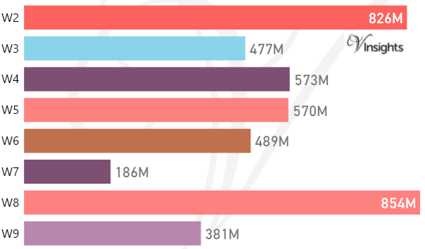
The Total Sales by the Postcodes are:
- W2 £826 millions, W3 £477 millions , W4 £573 millions
- W5 £570 millions, W6 £489 millions , W7 £186 millions
- W8 £854 millions, W9 £381 millions
Average & Median Sales Price By Postcode in 2016
Total Number Of Sales By Postcode in 2016
Multi Year Property Trend Analysis By Postcode
Schools for Postcode Area W
- London W Postcode Area - W1B, W1C, W1D, W1F, W1G, W1H, W1J, W1K, W1S, W1T, W1U, W1W School Details
- London W Postcode Area - W2, W3, W4, W5, W6, W7, W8, W9 School Details
- London W Postcode Area - W10, W11, W12, W13, W14 School Details
Posts for Postcode Area W
All W Postcodes Yearly & Trend Analysis Posts
Reference
W Postcode Area As Per Wikipedia
b0422be0-783a-48d6-9d16-0f7ba1ece8a2|0|.0|27604f05-86ad-47ef-9e05-950bb762570c
Please click here for the updated version of this post
This Post covers
- Coverage Area of Postcode W1B to W1W
- Total Sales By Postcode W1B to W1W
- Average & Median Sales Price By Postcode W1B to W1W
- Total Number of Sales By Postcode W1B to W1W
- Multi Year Property Trend Analysis By Postcode W1B to W1W
- Schools for Postcode Area W
- Posts for Postcode Area W
Coverage Area of Postcode W1B to W1W
Total Sales By Postcode in 2016
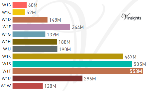
The Total Sales by the Postcodes are:
- W1B £60 millions, W1C £52 millions , W1D £148 millions, W1F £244 millions
- W1G £139 millions, W1H £188 millions , W1J £190 millions, W1K £467 millions
- W1S £505 millions, W1T £553 millions , W1U £296 millions, W1W £128 millions
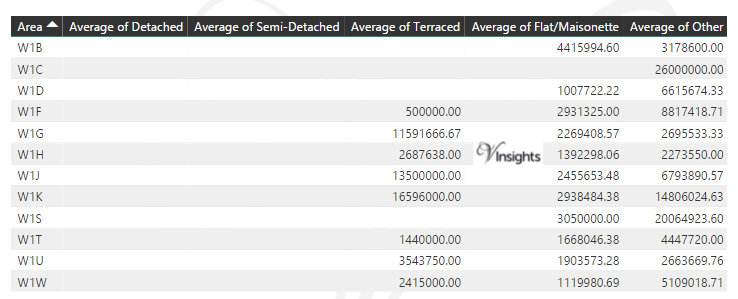
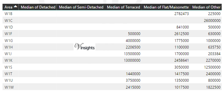
Average & Median Sales Price By Postcode in 2016
Total Number Of Sales By Postcode in 2016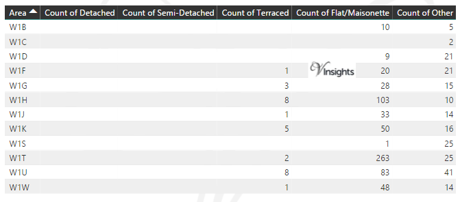
Multi Year Property Trend Analysis By Postcode
Schools for Postcode Area W
- London W Postcode Area - W1B, W1C, W1D, W1F, W1G, W1H, W1J, W1K, W1S, W1T, W1U, W1W School Details
- London W Postcode Area - W2, W3, W4, W5, W6, W7, W8, W9 School Details
- London W Postcode Area - W10, W11, W12, W13, W14 School Details
Posts for Postcode Area W
All Postcode Area Posts
Reference
W Postcode Area As Per Wikipedia
a8046eb2-cf8b-45e7-988a-f2955861273f|0|.0|27604f05-86ad-47ef-9e05-950bb762570c
Tags :
W1B Property Sales ,
W1C Property Sales ,
W1D Property Sales ,
W1F Property Sales ,
W1G Property Sales ,
W1H Property Sales ,
W1J Property Sales ,
W1K Property Sales ,
W1S Property Sales ,
W1T Property Sales ,
W1U Property Sales ,
W1W Property Sales
Please click here for the updated version of this post
This Post covers
- Coverage Area of Postcode UB7 to UB11
- Total Sales By Postcode UB7 to UB11
- Average & Median Sales Price By Postcode UB7 to UB11
- Total Number of Sales By Postcode UB7 to UB11
- Multi Year Property Trend Analysis By Postcode UB1 to UB6
- Schools for Postcode Area UB
- Posts for Postcode Area UB
Coverage Area of Postcode UB7 to UB11
Total Sales By Postcode UB7 to UB11 in 2016
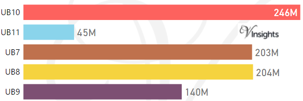
The Total Sales by the Postcodes are:
- UB10 £246 millions, UB11 £45 millions
- UB7 £203 millions, UB8 £204 millions , UB9 £140 millions
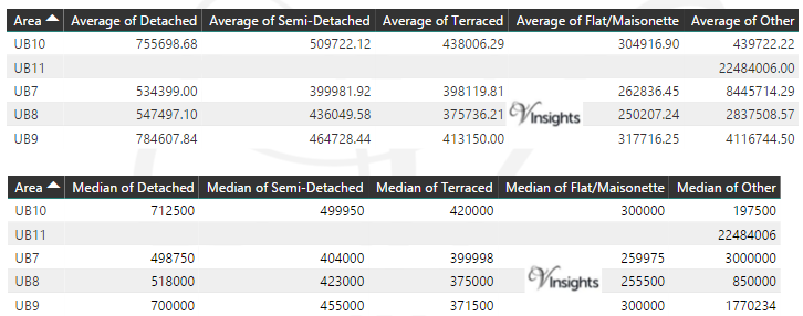
Average & Median Sales Price By Postcode in 2016
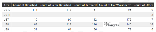
Total Number Of Sales By Postcode in 2016
Multi Year Property Trend Analysis By Postcode
Schools for Postcode Area UB
Posts for Postcode Area UB
All Postcode Area Posts
Reference
UB Postcode Area As Per Wikipedia
7f9c0f86-f4b2-40ac-ba60-972b0ca59a4f|0|.0|27604f05-86ad-47ef-9e05-950bb762570c