
This Post covers
- Coverage Area of Postcode GU10 to GU19
- School Details for Postcode Area GU10 to GU19
- Other Schools for Postcode Area GU
- Property Posts for Postcode Area GU
Coverage Area of Postcode GU10 to GU19
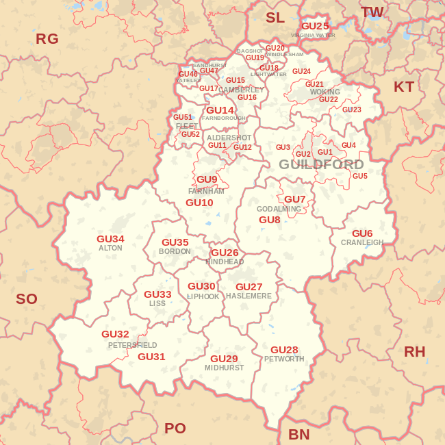 |
| Postcode |
Coverage Area |
Local Authority Area |
| GU10 |
Bentley, Frensham, Churt, Crondall, Tongham, Ewshot, Seale, Tilford, Wrecclesham |
Waverley, East Hampshire, Guildford, Hart |
| GU11 |
Aldershot |
Rushmoor
|
| GU12 |
Aldershot, Ash, Ash Green, Ash Vale |
Rushmoor, Guildford |
| GU14 |
Farnborough, Cove |
Rushmoor |
| GU15 |
Camberley, Old Dean, RMAS |
Surrey Heath, Bracknell Forest
|
| GU16 |
Frimley, Frimley Green, Deepcut, Mytchett |
Surrey Heath |
| GU17 |
Blackwater, Hawley, Minley, Darby Green, Frogmore, Blackbushe |
Hart |
| GU18 |
Lightwater |
Surrey Heath |
| GU19 |
Bagshot |
Surrey Heath |
where *F.S. = Faith School, *PERF = Performance, *D.F.E.=Department For Education
Schools in Postcode GU10
Schools in Postcode GU11
Schools in Postcode GU12
| School |
Postcode |
Phase |
Gender |
*F.S. |
Ofsted |
*PERF |
*D.F.E. |
Area |
| Alderwood School |
GU12 4RZ |
All Through |
Mixed |
N |
Rating |
Details |
Data |
Hampshire |
| Holly Lodge Primary School |
GU12 5PX |
Primary |
Mixed |
N |
Rating |
Details |
Data |
Surrey |
| Walsh Memorial CofE Controlled Infant School |
GU12 6LT |
Primary |
Mixed |
Y |
Rating |
Details |
Data |
Surrey |
| Walsh CofE Junior School |
GU12 6LT |
Primary |
Mixed |
Y |
Rating |
Details |
Data |
Surrey |
| Ash Grange Primary School |
GU12 6LX |
Primary |
Mixed |
N |
Rating |
Details |
Data |
Surrey |
| Ash Manor School |
GU12 6QH |
Secondary |
Mixed |
N |
Rating |
Details |
Data |
Surrey |
| Shawfield Primary School |
GU12 6SX |
Primary |
Mixed |
N |
Rating |
Details |
Data |
Surrey |
Schools in Postcode GU14
Schools in Postcode GU15
Schools in Postcode GU16
Schools in Postcode GU17
Schools in Postcode GU18
Schools in Postcode GU19
where *F.S. = Faith School, *PERF = Performance, *D.F.E.=Department For Education
Other Schools for Postcode Area GU
- GU Postcode Area - GU1, GU2, GU3, GU4, GU5, GU6, GU7, GU8, GU9 School Details
- GU Postcode Area - GU20, GU21, GU22, GU23,GU24, GU25, GU26, GU27, GU28, GU29 School Details
- GU Postcode Area - GU30, GU31, GU32, GU33, GU34, GU35 School Details
- GU Postcode Area - GU46, GU47, GU51, GU52 School Details
Property Posts for Postcode Area GU
All GU Postcodes Yearly & Trend Analysis Posts

0673641a-1a0d-4103-94ff-493f184fe33f|0|.0|27604f05-86ad-47ef-9e05-950bb762570c

This Post covers
- Coverage Area of Postcode GU1 to GU9
- School Details for Postcode Area GU1 to GU9
- Other Schools for Postcode Area GU
- Property Posts for Postcode Area GU
Coverage Area of Postcode GU1 to GU9
|
| Postcode |
Coverage Area |
Local Authorty Area |
| GU1 |
Guildford Town Centre, Slyfield, Merrow |
Guildford
|
| GU2 |
Guildford Park, Onslow Village, Park Barn, University of Surrey |
Guildford |
| GU3 |
Normandy, Puttenham, Worplesdon, Christmas Pie, Flexford |
Guildford |
| GU4 |
Burpham, Chilworth, Jacobs Well, Shalford |
Guildford |
| GU5 |
Albury, Bramley, Shere |
Guildford, Waverley |
| GU6 |
Cranleigh, Ewhurst, Alfold |
Waverley |
| GU7 |
Farncombe, Godalming |
Waverley |
| GU8 |
Chiddingfold, Dunsfold, Elstead, Hascombe, Milford, Thursley, Witley |
Waverley |
| GU9 |
Farnham, Badshot Lea, Hale, Heath End |
Waverley |
where *F.S. = Faith School, *PERF = Performance, *D.F.E.=Department For Education
Schools in Postcode GU1
Schools in Postcode GU2
Schools in Postcode GU3
Schools in Postcode GU4
Schools in Postcode GU5
Schools in Postcode GU6
Schools in Postcode GU7
Schools in Postcode GU8
Schools in Postcode GU9
where *F.S. = Faith School, *PERF = Performance, *D.F.E.=Department For Education
Other Schools for Postcode Area GU
- GU Postcode Area - GU10, GU11, GU12, GU14, GU15, GU16, GU17, GU18, GU19 School Details
- GU Postcode Area - GU20, GU21, GU22, GU23,GU24, GU25, GU26, GU27, GU28, GU29 School Details
- GU Postcode Area - GU30, GU31, GU32, GU33, GU34, GU35 School Details
- GU Postcode Area - GU46, GU47, GU51, GU52 School Details
Property Posts for Postcode Area GU
All GU Postcodes Yearly & Trend Analysis Posts
d14de221-e690-41f8-b783-324f8c2d0833|0|.0|27604f05-86ad-47ef-9e05-950bb762570c

This Post covers
- Coverage Area of Postcode CT18 to CT21
- School Details for Postcode Area CT18 to CT21
- Other Schools for Postcode Area CT
- Property Posts for Postcode Area CT
Coverage Area of Postcode CT18 to CT21
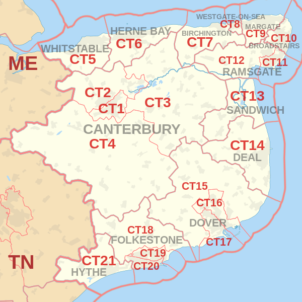 |
| Postcode |
Coverage Area |
Local Authority Area |
| CT18 |
Hawkinge, Lyminge, Etchinghill, Capel-le-Ferne, Densole, Newington |
Shepway, Dover |
| CT19 |
Folkestone (north), Cheriton |
Shepway |
| CT20 |
Folkestone (south), Sandgate |
Shepway |
| CT21 |
Hythe, Saltwood, Lympne, Postling, Newingreen, West Hythe, Westenhanger |
Shepway |
where *F.S. = Faith School, *PERF = Performance, *D.F.E.=Department For Education
Schools in Postcode CT18
| School |
Postcode |
Phase |
Gender |
*F.S. |
Ofsted |
*PERF |
*D.F.E. |
Area |
| Hawkinge Primary School |
CT18 7BN |
Primary |
Mixed |
N |
Rating |
Details |
Data |
Kent |
| Capel-le-Ferne Primary School |
CT18 7HB |
Primary |
Mixed |
N |
Rating |
Details |
Data |
Kent |
| The Churchill School |
CT18 7RH |
Primary |
Mixed |
N |
Rating |
Details |
Data |
Kent |
| Lyminge Church of England Primary School |
CT18 8JA |
Primary |
Mixed |
Y |
Rating |
Details |
Data |
Kent |
Schools in Postcode CT19
Schools in Postcode CT20
Schools in Postcode CT21
where *F.S. = Faith School, *PERF = Performance, *D.F.E.=Department For Education
Other Schools for Postcode Area CT
- CT Postcode Area - CT1, CT2, CT3, CT4, CT5, CT6, CT7, CT8, CT9 School Details
- CT Postcode Area - CT10, CT11, CT12, CT13, CT14, CT15, CT16, CT17 School Details
Property Posts for Postcode Area CT
All CT Postcodes Yearly & Trend Analysis Posts
05db03de-e772-4385-a689-a1ad22f76b23|0|.0|27604f05-86ad-47ef-9e05-950bb762570c

This Post covers
- Coverage Area of Postcode CT10 to CT17
- School Details for Postcode Area CT10 to CT17
- Other Schools for Postcode Area CT
Coverage Area of Postcode CT10 to CT17
 |
| Postcode |
Coverage Area |
Local Authority Area |
| CT10 |
Broadstairs, St Peter's |
Thanet |
| CT11 |
Ramsgate |
Thanet |
| CT12 |
Northwood, Minster-in-Thanet, Cliffsend, Monkton, Manston |
Thanet |
| CT13 |
Sandwich, Eastry, Woodnesborough, Great Stonar, Richborough |
Dover |
| CT14 |
Deal, Walmer, Kingsdown, Ringwould, Sholden, Great Mongeham, Worth, Ripple, Tilmanstone, Betteshanger |
Dover |
| CT15 |
Alkham, Lydden, Eythorne, St Margaret's at Cliffe, Elvington |
Dover |
| CT16 |
Whitfield, Temple Ewell |
Dover |
| CT17 |
River |
Dover |
where *F.S. = Faith School, *PERF = Performance, *D.F.E.=Department For Education
Schools in Postcode CT10
Schools in Postcode CT11
Schools in Postcode CT12
Schools in Postcode CT13
| School |
Postcode |
Phase |
Gender |
*F.S. |
Ofsted |
*PERF |
*D.F.E. |
Area |
| Sandwich Junior School |
CT13 0AS |
Primary |
Mixed |
N |
Rating |
Details |
Data |
Kent |
| Sandwich Technology School |
CT13 0FA |
Secondary |
Mixed |
N |
Rating |
Details |
Data |
Kent |
| Eastry Church of England Primary School |
CT13 0LR |
Primary |
Mixed |
Y |
Rating |
Details |
Data |
Kent |
| Sandwich Infant School |
CT13 9HT |
Primary |
Mixed |
N |
Rating |
Details |
Data |
Kent |
| Sir Roger Manwood's School |
CT13 9JX |
Secondary |
Mixed |
N |
Rating |
Details |
Data |
Kent |
Schools in Postcode CT14
Schools in Postcode CT15
Schools in Postcode CT16
Schools in Postcode CT17
where *F.S. = Faith School, *PERF = Performance, *D.F.E.=Department For Education
Other Schools for Postcode Area CT
- CT Postcode Area - CT1, CT2, CT3, CT4, CT5, CT6, CT7, CT8, CT9 School Details
- CT Postcode Area - CT18, CT19, CT20, CT21 School Details
All CT Postcodes Yearly & Trend Analysis Posts
60eeca34-3290-4830-ba67-85d7034af5d7|0|.0|27604f05-86ad-47ef-9e05-950bb762570c

This Post covers
- Coverage Area of Postcode CT1 to CT9
- School Details for Postcode Area CT1 to CT9
- Other Schools for Postcode Area CT
- Property Posts for Postcode Area CT
Coverage Area of Postcode CT1 to CT9
|
| Postcode |
Coverage Area |
Local Authority Area |
| CT1 |
Canterbury (south and city centre) |
Canterbury |
| CT2 |
Canterbury (north), Harbledown, Rough Common, Sturry, Fordwich, Blean, Tyler Hill, Broad Oak, Westbere |
Canterbury |
| CT3 |
Wingham |
Canterbury, Dover |
| CT4 |
Chartham, Bridge` |
Canterbury, Ashford |
| CT5 |
Whitstable, Seasalter, Tankerton, Chestfield, Swalecliffe, Yorkletts |
Canterbury |
| CT6 |
Herne Bay, Herne, Broomfield, Greenhill, Eddington, Beltinge, Reculver |
Canterbury |
| CT7 |
Birchington-on-Sea, St Nicholas-at-Wade, Sarre, Acol |
Thanet |
| CT8 |
Westgate-on-Sea |
Thanet |
| CT9 |
Margate, Cliftonville, Birchington |
Thanet |
where *F.S. = Faith School, *PERF = Performance, *D.F.E.=Department For Education
Schools in Postcode CT1
Schools in Postcode CT2
Schools in Postcode CT3
Schools in Postcode CT4
Schools in Postcode CT5
Schools in Postcode CT6
Schools in Postcode CT7
Schools in Postcode CT8
Schools in Postcode CT9
where *F.S. = Faith School, *PERF = Performance, *D.F.E.=Department For Education
Other Schools for Postcode Area CT
- CT Postcode Area - CT10, CT11, CT12, CT13, CT14, CT15, CT16, CT17 School Details
- CT Postcode Area - CT18, CT19, CT20, CT21 School Details
Property Posts for Postcode Area CT
All CT Postcodes Yearly & Trend Analysis Posts
ea685144-8e81-4762-bd42-0bb9b2d0d52a|0|.0|27604f05-86ad-47ef-9e05-950bb762570c